The same major weather system that slammed Texas and the lower Mississippi Valley with severe weather will bring gusty winds to the D.C. area this weekend.
The National Weather Service said they have issued a wind advisory for Saturday’s expected 50-mile gusts and a high wind warning for Virginia’s Blue Ridge starting at 10 a.m.
- Listen to WTOP online and on the radio at 103.5 FM or 107.7 FM.
- Current traffic conditions
- Weather forecast
- Sign up for WTOP alerts
Storm Team 4 meteorologist Mike Stinneford says D.C. area residents should expect trees to fall and brace for power outages.
Friday’s rain and increasing easterly wind is a precursor to stronger gusts that is forecasted to push across the national capital region on Saturday.
Those weather conditions may cause traffic disruptions on the Chesapeake Bay Bridge, according to the Maryland Transportation Authority. It said commuters may encounter eastbound traffic delays during Friday’s afternoon rush hour and authorities will assess weather conditions before implementing any changes.
Developing low pressure is expected to sweep a cold front through around daybreak on Saturday, with a burst of wind expected. The strongest gusts will likely occur during daylight hours on Saturday, reaching 45 miles per hour in much of the metropolitan D.C. area.
Winds will subside by Sunday, and it will be a sunny and breezy day.
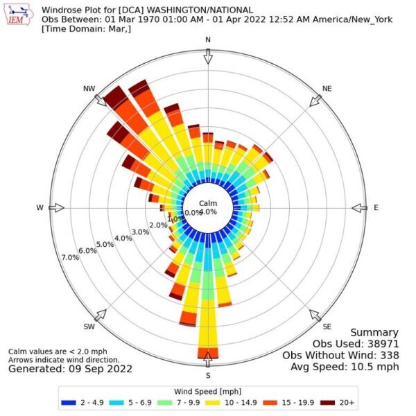
The early March weather system comes right on cue with D.C.’s historically windiest month of the year. The average wind speed is 10.5 mph, with April ranking as the District’s second windiest month at 10.1 mph.
Additionally, a northwest wind bringing the strong gusts coincides with the very gusty northwest wind expected in the front’s wake on Saturday.
Spring is traditionally the gustiest season in the D.C. region due to large temperature swings as still chilly Canadian and Arctic air pours south and teams up with an increasingly warm, humid air mass that pushes north from the Gulf of Mexico.
The clash of air masses helps to fuel strong fronts and low pressure centers. The coldest air behind this weekend’s front will stay west of the Appalachians.
August is historically D.C.’s least windy month of the year and the summer month with the fewest gusty thunderstorms. It’s the month before the height of the tropical weather season and few frontal passages occur in this last month of meteorological summer.
Forecast
SATURDAY: Partial clearing, very gusty winds with isolated power outages expected. High temperatures in the upper 50s.
SUNDAY: Mostly sunny to partly cloudy and pleasant. High temperatures near 60.
MONDAY: Mostly sunny. High temperatures near 60.