One week into March, Mother Nature is turning the clock backwards from mid-to-late spring weather to a late winter and early spring pattern. The dry air mass and sunshine make for an elevated brush fire risk across the D.C. area on Tuesday.
A dry, Canadian air mass oozing into the D.C. region will return wall-to-wall sunshine Tuesday afternoon, an increasing northerly breeze and a drop in humidity.
Wednesday will be a carbon-copy with lots of sunshine, a brisk north wind and low humidity in the afternoon.
This is the prime pattern for an increase in brush fires, though a red flag warning isn’t in effect for Tuesday or Wednesday and the D.C. area isn’t in a drought.
The National Weather Service is monitoring conditions Tuesday.
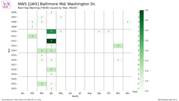
March and April are the prime months for the local weather service to issue red flag warnings.

These alerts are issued when a combination of sunshine, breezy wind and a dry air mass drop humidity to very low levels (usually below 30%).
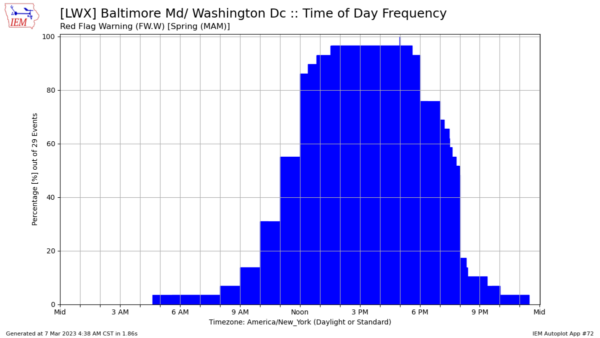
Red flag warnings are most common in the spring before the trees become full of leaves because the vegetation traps moisture and humidity at the surface. The warnings are most likely to be in effect from 1 to 5 p.m. when humidity on a dry, windy day is the lowest.

The best practice on a dry, windy day is to never throw a lighted cigarette out the window. Don’t burn brush in the backyard and closely monitor the outdoor grill when having a cookout — hot charcoal that escapes can quickly start a brush fire.
It doesn’t take a drought to trigger brush fires.
Stay tuned to WTOP for the latest wind and fire weather alerts and updated forecast on the 8’s.


