Just as the calendar flips to February, the D.C. area finally got its first dose of snow Wednesday morning. The remainder of the winter looks mild, but there’s one last hope for snow-lovers: groundhog Punxsutawney Phil.
The fuzzy forecaster is set to make his yearly prediction on Thursday.
How did Groundhog Day come about?
Thursday will mark the 136th celebration of Groundhog Day in Punxsutawney, Pennsylvania.
The holiday stems from the long-standing tradition of German immigrants who celebrated Candlemas Day, marking the celebration with clergy who would bless and distribute candles that represented how long and cold the winter would be.
When this belief was brought into Germany, they used a hedgehog to decide the weather prediction. A bright day would allow him to see his shadow, get scared and scurry back into his burrow. This signified another six weeks of winter was ahead.
Back in the 1800s, a traditional folk song chanted on Candlemas Day became a weather prognostication tune and read as follows: “If Candlemas be fair and bright, Come Winter, have another flight. If Candlemas brings clouds and rain, Go Winter and come not again.”
A cloudy and rainy day would not allow him to see his shadow, so he would be content outside and not hurry back to his burrow. This meant spring would soon arrive.
German settlers arrived in the U.S. only to realize we had no hedgehogs in the states, so a groundhog was used instead to make these bold predictions. And so, Punxsutawney Phil came to be.
What is Phil’s track record?
His track record favors six more weeks of winter because he has seen his shadow 106 times versus 20 times not seeing his shadow. Ten times were not recorded, so there’s no word on Phil’s prediction.
Phil was on point last year — he predicted six more weeks of winter and D.C. accumulated 6.4 inches of snow after Feb. 2.
Let’s examine the District’s track record of snowfall on and before Groundhog Day and then after the holiday to see if Phil has picked up on recent climate changes in D.C.
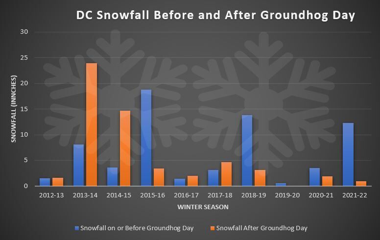
Over the last decade, the trend has been for snowfall to shift before Feb. 2 and have spring arrive early (sorry Phil). The winters of 2012-13 to 2017-18 brought a snow-heavy back end to winter that has since transitioned to more of a front-loaded winter.
The trend going forward after Wednesday morning’s snowy spell isn’t promising for snow lovers in the East. As a matter of fact, D.C. will likely set a few record highs as opposed to diving into a snowy, cold pattern.
March could bring minor snow accumulation before the District zooms into spring. While four previous winters, including 1997-98, 1972-73, 1949-50 and 2019-20 never produced even an inch of snow in D.C., the latest first inch of snow on record was March 24, 2013.


