While the weather pattern offers up no chance for measurable snow in the D.C. region, when can we expect the warmest and coldest weather? The answer may surprise you.
Mother Nature is going through her fusses already this month. The Arctic front dropped the temperature to a chilling 16 degrees on Saturday while Sunday’s high of 59 degrees was 13 degrees above average.
With a 43-degree temperature spread within 24 hours this weekend, D.C. is most likely to have its warmest and coldest day in February. Now that we’ve gone through 43 degrees of temperature change within a 24-hour period, you may be wondering what’s next.
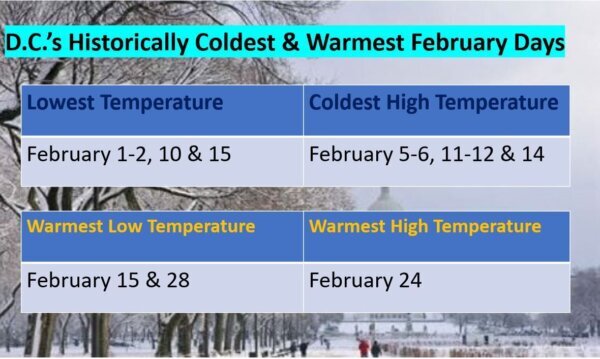
Based on years of observations at Reagan National, if we don’t reach our coldest low temperature of the month within the first two days, Mother Nature finds a way to sweep in the chill on Feb. 10 and then again five days later on Feb. 15.
If we don’t have our coldest afternoon on Feb. 5 and 6, a cold front finds its way through the D.C.-area by Feb. 11-12 and 14 (Valentine’s Day) to produce the month’s coldest high temperature.
When in February does D.C. frolic in spring warmth? Historical data shows that D.C. can ditch the jackets in the mornings on Feb. 15 and then again on the last day of the month (28th for non-leap years). Feb. 15 shows up in the data as the most frequent day for either a very chilly or quite a warm start.
Mark your calendar for Feb. 24, which happens to be a Friday this year because historically, that is the warmest day of February.

Of course, this data is solely based on statistics, but it sheds light on the variability in the weather pattern in our region for the final month of meteorological winter.
Stay with WTOP for your forecast on the 8’s.


