The 60-degree weather on New Year’s Day wasn’t teasing the D.C. region; there’s no sign of an incoming Arctic blast. The warm pattern is expected to hold, at least for now.
And the mild weather isn’t entirely uncommon for early January.
- Listen to WTOP online and on the radio at 103.5 FM or 107.7 FM.
- Current traffic conditions
- Weather forecast
- Closings and Delays
- Sign up for WTOP email alerts
- Get custom alerts with the WTOP app for Apple and Android phones
On the heels of the Siberian Express on Christmas Eve and Christmas Day, the weather pattern did a complete 180.
Instead of a big dip in the jet stream bending south in the East, the Pacific jet stream has come screaming into the West Coast and flooded the U.S. with warmth. The Pacific jet stream, now in overdrive, is producing flooding across California in a pattern known as an ‘Atmospheric River.’
The end result this week for the D.C. region is a string of well-above average temperatures that will challenge daily records. Sunday’s high temperature above 60 degrees will be repeated each afternoon through Wednesday, if not again on Thursday.
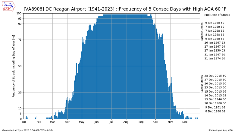
So, how common is a five-day consecutive stretch of 60-degree days in the District? It’s happened on five different occasions.
In January of 1947, 1950, 1967, 1974 and 1998, D.C. had a 5-day streak with high temperatures at or above 60 degrees. Of these years, two were La Nina winters; 1950, 1974, and one (1998) was a Super El Nino winter.

The two best analogs include the 1950 and 1998 streaks due to the early month timing. During both years, January’s snow total in D.C. was less than one inch.
The other January’s mentioned didn’t come close to producing amounts at or above the 30-year average of 4.9 inches of snowfall. January 1974 came the closest with 4.1 inches of snow in Washington.
Stay tuned to WTOP for the latest forecast on the 8’s as meteorologists track the early month warmth followed by a transition closer to seasonal averages later in the week.


