Christmas Eve was one of the coldest ones the District has ever experienced, and the arctic chill will continue into Christmas Day on Sunday.
“With this massive Arctic air mass now fully entrenched across much of the nation, the Washington Capital Region will not feel temperatures above freezing before Monday at the earliest,” Storm Team4 meteorologist Clay Anderson said.
Areas well north and west of the metro area will have to wait until Tuesday to experience temps above freezing. It’s truly a Christmas holiday weekend for the record books.
Christmas Day will be almost as cold as Christmas Eve, with highs near 30 degrees, but have far less of a breeze to contend with. Most areas will get above to freezing on Monday afternoon, be near 35 degrees on Tuesday and get back to 40 degrees by Thursday.
“I think the important thing is for people to stay safe and just because the sun is out, don’t step on the gas because once you hit that ice it doesn’t matter whether it’s sunny or not, the car is going to slide,” said Anderson.
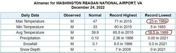
The average temperature on Saturday put it in the ranks with Dec. 24, 1989 as the coldest Christmas Eves on record in D.C.
Wind damage was a big problem Friday, with winds gusting at 55 mph at Dulles International, 69 mph at the Bay Bridge and 56 mph in the District. The inclement weather caused multiple delays on rail services, including MARC train and Amtrak, while trees toppled over in area neighborhoods.
“We are so far below freezing, we are below zero, and so many areas, and that’s just something that we don’t see too often around our area,” Storm Team4 Chief Meteorologist Doug Kammerer told WTOP.
Ironically, Washington’s average temperature so far in December up until Thursday night – before the cold blast arrived – was almost identical to the historical average for Dec. 1 through 22 of 42.6 degrees; D.C.’s average temperature during this time range in 2022 was 42.2 degrees.
For those yearning for warmer weather, the weather pattern will flip-flop late next week. The strong stratospheric polar vortex is going to link up with the troposphere – where the weather occurs – and bottle the cold air back up in the Arctic while the U.S. undergoes significant warming. The transition day into the warmer pattern could bring the D.C. region its first flurries during the midweek.
- Listen to WTOP online and on the radio at 103.5 FM or 107.7 FM.
- Current traffic conditions
- Weather forecast
- Sign up for WTOP alerts
- Power Outages
- What should be in your emergency kit
- How to prepare for power outages
Outages
As temperatures continue to tumble, some residents have experienced power outages leading into the weekend.
Pepco reported just under 70 customers in Montgomery County, Maryland without power. In addition, Baltimore Gas and Electric company said that close to 40 homes in Prince George’s County and about 170 more in Anne Arundel County were in the dark.
Outages have also been reported in Northern Virginia, where Dominion Energy reported between 380 customers in Loudoun County and over 250 in Fairfax County customers without power.
If you get caught without power, Dominion Energy spokeswoman Peggy Fox says to make or grab your emergency kit, fire up your generator if you have one, and check in on your neighbors. If all else fails, pack a bag and try to safely brave the roads.
“It is good to know where your medication is. While it’s light outside, make sure you gather things together,” Fox said. “Check on your neighbors … check on your loved ones. Please make sure you have plans to go somewhere else if it gets too cold in your house.”
Make sure you also report the outage to your local energy provider.
For those dealing with power outages and low heat, Chief Spokesperson for Montgomery County Fire & Rescue Service Pete Piringer says that you should plan, especially on the roadways.
Forecast
Sunday, Christmas Day: Mostly sunny, bitter cold and breezy at times. Highs in the mid-20s to 30 degrees. Winds: West 8-18 mph. Wind chills will be near 15 degrees.
Monday: Mostly sunny and cold. Highs in the upper 20s to mid-30s. Winds: Northwest 5-10 mph. Wind chills will be in the mid-20s.
Tuesday: Partly cloudy with highs around 40 degrees.