Hot on the heels of the warmest first week in November across the nation’s capital, Mother Nature has a few tricks up her sleeves for the second half of the month.
Temperatures during November’s first seven days were 0.2 degrees warmer than the former record in 2003 and 17.5 degrees warmer than last year. Monday’s high of 81 degrees at Reagan National Airport was the fourth latest 80-degree day in Washington since records began in 1872 and the latest 80-degree day since 1993. The 30-year temperature averages indicate the next 80-degree day is not anticipated until mid-May.
While Subtropical Storm Nicole will make headlines this week along the East Coast, it will come with a big pattern shift over the weekend.
A major storm sweeping into the West will link up with a front across the Plains late this week and bring wind-driven snow to the Dakotas. As it pushes east, the front will link up with Nicole from Friday to early Saturday and spread heavy rain and scattered flooding east of the Ohio Valley, including the Washington metro area.
In its wake, a deep trough will push the coldest weather of the season into the D.C. region. The northwest wind will be particularly breezy Saturday afternoon in the front’s wake. Gusts reaching 40 to 47 mph could trigger wind advisories, particularly along and west of the Blue Ridge by Saturday afternoon. These winds will bring down any remaining leaves still intact across the DMV.
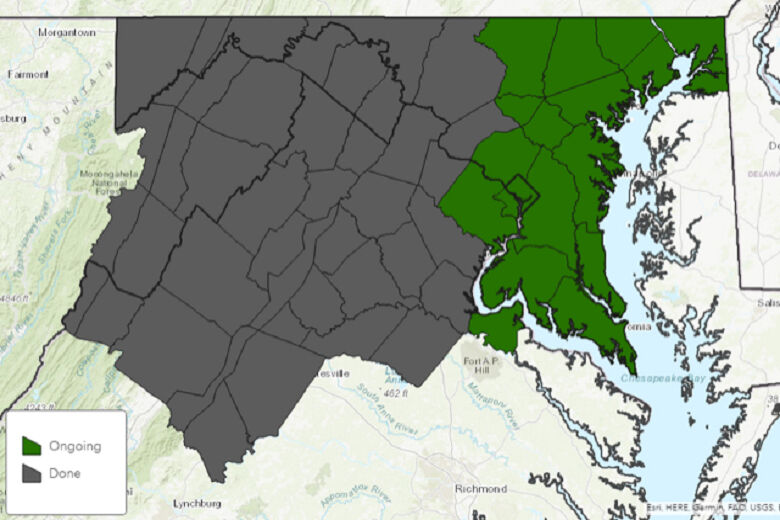
Canadian high pressure swooping into the Great Lakes later this weekend will then bring in the coldest weather of the season. Temperatures on Monday through Wednesday morning will drop below freezing inside the Capital Beltway to the Chesapeake Bay. This seasonably cold air mass will officially end the growing season for the year where it is currently ongoing along and east of Interstate 95.
Mid-November is right in line with the first autumn freeze of the season in Washington. By comparison, below is a table showing the dates of the previous first hard freeze of the season dating back the last 10 years.
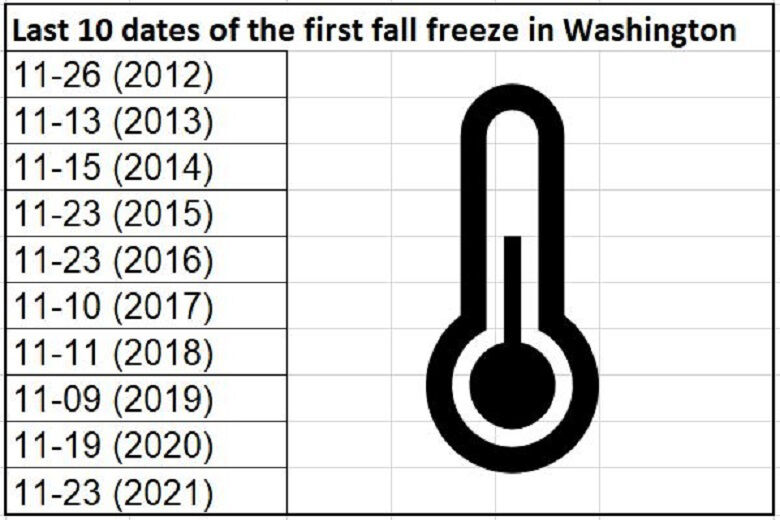
If you are wondering how much snow occurred in the winter following the best-matched November freeze dates: 19.3 inches of snow accumulated in the 2013-14 winter and 13.4 inches fell in the 2014-15 winter. It could be a sign of a winter similar to last year when 12.3 inches of snow coated the District.


