Just as a historic lake-effect snow event buries southwest New York, it’s important to realize where these snow bands set up totally depend on wind direction. So, can D.C. see lake-effect snow?
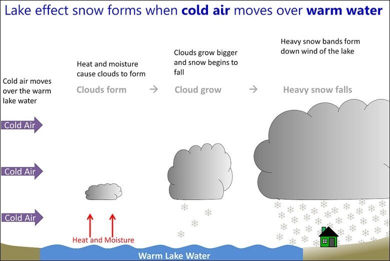
The key to lake-effect snow development is a big temperature difference between the warm Great Lakes and a bitter cold air mass. Late this week, the air about 5,000 feet up moving over the Great Lakes is 14 degrees Fahrenheit, while the water temperatures are in the mid 40s.
This extreme temperature difference can also trigger thundersnow, basically a thunderstorm with snowfall rates easily exceeding two inches per hour.
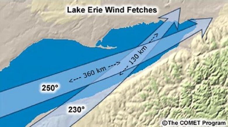
The longer the wind fetch across any of the lakes (the wind blowing parallel to the longest part of the lake), the more snow will dump in adjacent locations next to the lake.
Besides the perfect temperature recipe, the current southwest wind is the longest fetch along Lake Erie for snow to pile up downwind in Buffalo.
Early in the event on Friday morning, snowfall totals have reached a foot to 16 inches near Buffalo. Snowfall amounts exceeding four feet will paralyze that region of New York state through the weekend.
It’ll take until Saturday night for the wind to switch to the northwest and very heavy snow bands to shift south toward places like Jamestown, and Erie, Pennsylvania, where eight to 12 inches are expected.
So, can the D.C. region see lake-effect snow? The short answer is yes, but many factors have to come together.
A well-aligned northwest wind from the surface to 10,000 feet on the heels of an Arctic cold front will carry very heavy lake-effect snow bands (similar to the bands pummeling Buffalo) into the Northern Appalachians. In the D.C. region, moisture dries out over the Appalachians when snow bands approach, so what starts out as a heavy snow squall over places like Somerset and Johnstown, Pennsylvania, ends up as a few flurries along Interstate 95.
However, if a weak low pressure trails in the Arctic air mass, then the moisture mostly stays intact over the mountains and the D.C. area could end up with more than flurries. A few bursts of heavier snow can quickly accumulate on roadways and trigger problems. Usually, these snow bursts occur on occasion in late December to mid-January when the Arctic air mass is the coldest of the year and Great Lakes are still relatively milder than the air temperature.
Looking ahead, a front will likely deliver rain either late on Thanksgiving Day or Black Friday. This will be followed by an Arctic air mass that could be cold enough with the right wind trajectory to bring D.C. flurries to close out the holiday weekend. Stay with WTOP for weather updates on the 8’s of the hour!