Nicole is on the verge of becoming a hurricane as it churns toward Florida’s Atlantic coast.
It will accelerate across the Sunshine State, chug into the Southeast — and is then expected to reach the D.C. area by Friday night with heavy rain and potentially severe weather.
Locally, the clouds will begin to push into the area later Wednesday and into Thursday. Low clouds, drizzle and spotty fog will develop along Skyline Drive in Virginia Wednesday night as the air becomes increasingly more humid.
The first round of heavy rain will push through the region Friday morning. A couple of showers will linger during the day before Nicole, which by then will probably be downgraded to a tropical depression, pushes across the D.C. metro area Friday night.
Nicole’s approach will bring a final deluge late Friday afternoon into the evening. Areas south and east of its track — likely Southern Maryland and Delmarva — have the best chance at a few gusty storms, and even a low risk for a brief tornado to spin up.
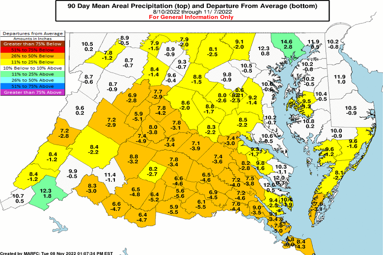
Although the entire region has been dry — with rainfall deficits since mid-August reaching 2 1/2 inches in Washington to 3 1/2 to 4 inches in central Virginia — the downpours will be enough to trigger localized flash flooding on Friday.
Leaves blocking storm drains are most susceptible for water to build up and pond. Anyone who lives near a smaller stream, though, should watch out for minor flooding. Because the leaves are predominantly off the trees and the ground is dry, much of the rain will quickly run off into those smaller streams. Area rivers and larger creeks will be able to handle the water, because their levels have been running well below average lately.
It’s also a good idea to remove excess leaves from gutters ahead of the storm.
The axis of more widespread flooding will be west of Nicole’s circulation center in the Alleghenies to the Interstate 79 corridor, where 2 to 4 inches of rain will fall.
Nicole will be a figment of the imagination by daybreak Saturday as it zips into the Northeast, but a gusty northwest wind will be unleashed across the area during the day. The strongest winds will blast the Appalachians in Nicole’s wake Saturday.
The coldest air of the season will follow Sunday into early next week.