The coldest air of the season is taking aim at the D.C. region early this week and is expected to produce a widespread killing frost northwest of the Capital Beltway.
The front is producing light snow in Green Bay, Wisconsin, Monday morning and making a beeline for Washington between 7 p.m. and 10 p.m. The front has very little moisture, so the only noticeable sign it moved through will be a burst of wind followed by rapidly falling temperatures.
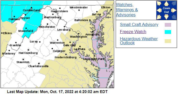
Temperatures will be cold enough for temperatures to drop into the 20s for several hours Tuesday morning in far Western Maryland where a hard freeze will kill all outdoor plants and flowers.
The polar plunge will continue to sweep across Washington Tuesday into Wednesday. Each day will be characterized by sunshine at daybreak and then developing layered clouds and a breezy northwest wind by late morning. While the clouds won’t mean much locally, they will produce snow showers along the Allegheny Plateau about 170 miles west of Washington.
Travelers heading west on Interstate 68 will encounter these snow showers Tuesday afternoon to Wednesday morning after crossing into Maryland’s westernmost county. Be prepared for a few slippery spots, especially on secondary roads.
Tuesday’s lows will drop into the lower 30s from northern Montgomery County into central and northern Maryland and Virginia to Interstate 81 where frost is likely to develop. Ultimately, the coldest air mass will settle in Wednesday morning with temperatures dropping to 28 degrees for several hours from Upper Montgomery County to the Mason-Dixon Line, west into much of Virginia and I-81.
All outdoor vegetation will suffer severe cold weather damage, and ultimately, the growing season will come to an end.
This means future cold outbreaks dropping temperatures below freezing will not instigate additional Frost Advisories and Freeze Watches/Warnings in the zone from northern Montgomery County to central and northern Maryland and Virginia and points west to I-81.
While scattered frost could occur from D.C. to the Chesapeake Bay, a widespread hard freeze is not expected. Therefore, Frost Advisories and Freeze Watches/Warnings will be issued for the next burst of cold weather from Interstate 95 to the Chesapeake Bay, which won’t occur for at least the next week.