While high pressure has turned off Mother Nature’s spigot lately, if it seems like you needed an umbrella often this summer, you aren’t kidding!
The D.C. region’s Reagan National Airport is running just ahead of its rainfall average this month. August was just shy of average, but July overproduced with 7.61 inches of rain.
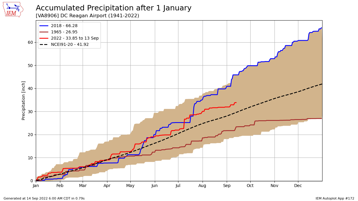
Looking back to the start of the calendar year, the red line on the image below shows a running tally of this year’s precipitation total at Reagan Airport. Notice the red line stays above both the previous wettest year, 2018, and the 30-year average until recently.

This means the D.C. area had been on track for the wettest calendar year — until hitting a snag in June. This is where on the graph, the red line dips closer to the dashed line, the 30-year climate average. Rainfall was 1.24 inches below average in June.
Then, the weather pattern allowed for stalled fronts to produce the 13th wettest July on record. Since then, the area has seen its fair share of rain, but has fallen short of 2018.
While September has been soggy, the traditional peak of the hurricane season can help tip the bucket if one or more tropical systems clip or make a head-on impact with the region. That’s exactly what September 2018 brought: Moisture from Tropical Storm Gordon early in the month followed by Hurricane Florence in mid September.
The area will stay on track for a wet year if the weather pattern stays active through the end of December. To put things into perspective, D.C. averages 12.24 inches of precipitation from where we are now in September through the end of the calendar year.
2018 produced a grand total of 66.28 inches and we’ll need another 32.43 inches before Dec. 31 to catch up to that year. Annually, D.C. averages 41.82 inches of precipitation.


