Chances of rain will increase early this week as Tropical Storm Isaias moves closer to the area, with a possibility for torrential tropical downpours and flooding in the D.C. region.
The National Weather Service issued a tropical storm watch for much of the region, and areas east of Interstate 95 are under a flash flood watch.
The weather service said the biggest impact to this area will likely be the flooding that the storm brings on Monday evening and into Tuesday. They said coastal flooding could also be severe.
Due to Tropical Storm Isaias’ threat to our area, a Tropical Storm Watch has been issued for counties along the I-95 corridor and east. Flash Flooding will likely be our biggest impact Mon eve – Tue eve. Tidal/coastal flooding (Tue and Tue eve) is also a concern. Stay informed. pic.twitter.com/ClQOF1a9Oi
— NWS Baltimore-Washington (@NWS_BaltWash) August 2, 2020
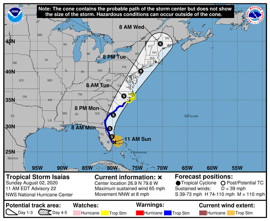
Even though the storm weakened from a hurricane on Saturday, Isaias — currently near Florida — is forecast to parallel the U.S. East Coast, according to NBC Washington meteorologist Lauryn Ricketts, a path which would bring tropical storm conditions to the region from Monday night through Tuesday.
- Listen to WTOP online and on the radio at 103.5 FM or 107.7 FM.
- Current traffic conditions
- Weather forecast
- Closings and Delays
- Sign up for WTOP alerts
The storm — pronounced ees-ah-EE-ahs — had already prompted Virginia Gov. Ralph Northam to declare a state of emergency for the potential of heavy rain and gusty winds from coastal Virginia through Maryland’s Eastern Shore.
While Isaias’ path is still uncertain, it appears increasingly likely that eastern Virginia could be impacted and must prepare for the possibility of flooding, high winds and potential storm surge, a news release from Northam’s office said.
The National Hurricane Center’s official forecast track as of Sunday morning had Isaias making landfall as a strong tropical storm in the Carolinas late Monday, before racing northward over the Chesapeake Bay through New Jersey with sustained winds between 45 and 60 mph.
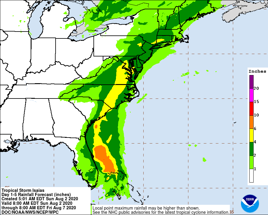
Parts of the WTOP listening area could see rain totals of up to 6 inches, enough to pose a significant flash flood threat.
“Confidence for the heavy rainfall is highest along and east of the Blue Ridge Mountains, but the area may shift depending on the exact track of Isaias,” the National Weather Service’s D.C. regional office said in its Sunday forecast discussion.
“The best chance for tropical storm force winds will be near and east of the center of Isaias, but the heavy rainfall may extend well north and west from the track of Isaias.”
D.C. Mayor Muriel Bowser asked residents Friday to prepare for the possibility of heavy rain and high winds.
Bowser said in a news release that the D.C. Homeland Security and Emergency Management Agency had begun emergency planning with its local, regional and federal partners; and more information will be provided as the hurricane’s trajectory becomes more precise.
The Virginia Hurricane Evacuation Guide During the COVID-19 Pandemic outlines preparedness, response and recovery actions, and Northam urged Virginians in coastal areas who may be affected to consult it in making their preparations.
For more on hurricane preparation, go to the FEMA website. Find more tips on the Ready DC website and the Virginia Department of Emergency Management.
WTOP’s Alejandro Alvarez and The Associated Press contributed to this report.
Forecast:
Sunday night: Scattered showers and thunderstorm. Mostly cloudy, with lows in the mid 70s.
Monday: Increasing clouds and muggy, with heavy rain likely into the evening. Highs in the mid to upper 80s.
Tuesday: Heavy rain, steady at times. Tropical storm conditions possible, especially in coastal areas. Highs in the upper 70s.
Wednesday: Mostly sunny and less humid. Isolated thunderstorms possible. Highs in the mid 80s.
Thursday: Mostly sunny. Highs in the mid 80s.


