The worst of the icy conditions from Tuesday’s snow have eased in the D.C. area, but a wind advisory was issued for most of the area for most of the day Wednesday.


The National Weather Service issued a wind advisory for the D.C. metro area and points north, as well as areas along the Blue Ridge Mountains, from 11 a.m. to 5 p.m. Winds could gust up to 40 mph, which could result in some downed trees and power outages.
A Wind Advisory has been issued for areas along and west of the Blue Ridge Mountains and the DC metro areas and northward until 5 pm today. Check our website: https://t.co/CJFhYzBvKR for more information. pic.twitter.com/AkvYuLs22Y
— NWS DC/Baltimore (@NWS_BaltWash) January 8, 2020
Here’s what else you need to know:
- Expect more backups near military facilities due to increased security and gate changes
- Quick bursts of snow are still possible in northern Maryland and west of the Blue Ridge, making driving difficult
- Gusty winds could mean downed trees and scattered power outages Wednesday afternoon
- Listen to WTOP online and on the radio at 103.5 FM or 107.7 FM.
- Current traffic conditions
- Weather forecast
- Closings and Delays
- Sign up for WTOP email alerts
- Get custom alerts with the WTOP app for Apple and Android phones
Weather alerts
A wind advisory is in effect for the following counties in the WTOP listening area from 11 a.m. to 5 p.m. Wednesday. The forecast calls for gusts of up to 40 mph, strong enough to bring down tree limbs and wires.
- Washington, D.C.
- In Maryland: Montgomery, Prince George’s, Howard, Anne Arundel, Frederick and Baltimore counties, including the city of Baltimore.
- In Virginia: Arlington, Loudoun, Fairfax, Prince William and northern Fauquier counties, as well as the cities of Alexandria, Fairfax, Falls Church, Manassas and Manassas Park.
There’s also a wind warning in effect on the Bay Bridge — “operators of house trailers, box trailers, motorcycles, vehicles with roof-mount racks containing cargo or any other vehicle that may be subject to high winds are advised to use caution while traveling across the bridge,” the Maryland Transportation Authority says. Wind gusts are hitting 39 mph — just short of the 40-mph threshold that would lead to the prohibition of such vehicles.
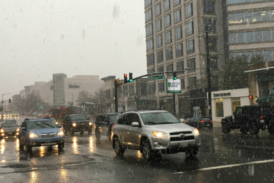
Icy conditions and snow squalls threatened Wednesday morning travel in the early morning, leading many D.C. region schools to open on a delay or close altogether.
Black ice proved a new problem: Temperatures dove below freezing overnight, and a lot of drivers faced spin-outs, fallen trees and downed power lines. And in parts of northern Maryland and Virginia, lingering bands of heavy snow added to travel woes.
Several Maryland and Virginia school districts announced closures and delays Wednesday. See WTOP’s full list of closures and late openings for more details.
Northern Maryland dealt with quick-moving but intense snow squalls this morning.
NBC4’s Lauryn Ricketts noted snowy squalls slowing travel along I-270 and I-95 between Frederick, D.C. and Baltimore. That snow won’t accumulate much, but they’ll rapidly make driving difficult with blowing snow for commuters caught in them.
#SnowSquall blasts through #MdTraffic pic.twitter.com/KcOYXDjFAh
— WTOP Traffic (@WTOPtraffic) January 8, 2020
On I-95 before Quantico in Virginia, some drivers were trapped in standstill traffic for around six hours early Wednesday while crews worked to clear a deadly crash involving a tractor trailer.
All 3 lanes of I-95 North now open for traffic, w only activity on shoulder, after fatal crash and investigation that snarled traffic for 6 hours in Quantico area. pic.twitter.com/tXwpTyTMEf
— Neal Augenstein (@AugensteinWTOP) January 8, 2020
For the latest road and traffic conditions, see WTOP’s traffic page or listen to updates every 10 minutes online or on the air at 103.5 FM. Submit traffic tips by calling 866-304-WTOP or tagging @WTOPtraffic on Twitter.
“Our quick burst of snow will soon be nothing more than a memory,” NBC Washington forecaster Chuck Bell told WTOP. “There are many icy spots on area roads this morning so use extreme caution on your way to work and school.”
For the immediate D.C. region, Tuesday’s weather had more people talking about the ungodly Capital Beltway traffic than snow totals. The storm definitely brought heavy snow — at a rate of over an inch per hour at times — but thanks to its short duration and warm surface temperatures, it didn’t really stick.
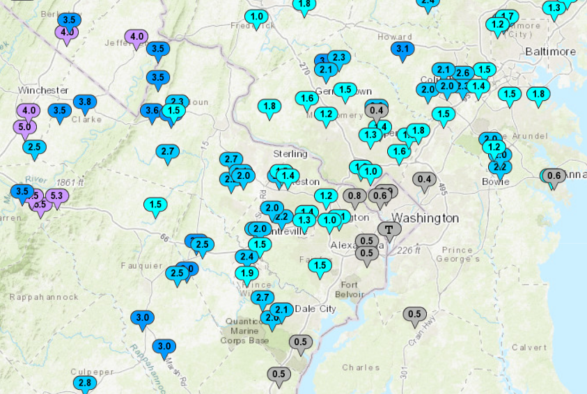
D.C. itself reported a measly dusting to an inch of snow by Tuesday evening, with slightly higher amounts driving up I-270 through Montgomery and Frederick counties in Maryland.
Just like the forecast had called for, you’d have to look toward the higher elevations of Virginia and Maryland along the Blue Ridge for more significant totals of four to five inches.
See a full list of storm totals from the National Weather Service.
After Wednesday, it’s smooth sailing — and looking at the forecast, one might even be fooled into thinking winter is ending in mid January: Temperatures will be in the mid- to upper 60s all weekend.
Forecast
Wednesday: Partly sunny and windy, with passing snow showers possible mainly north and west of D.C. Highs in the low to mid-40s.
Wednesday night: Clear but freezing. Lows in the upper 10s to low 20s.
Thursday: Mostly sunny. Highs in the upper 30s to low 40s.
Friday: Mostly cloudy with rain showers possible late. Highs in the mid-50s.
Saturday: A dream of spring? Cloudy, with highs in the mid- to upper 60s.