A winter wonderland this ain’t.
What began as snow or sleet before dawn Monday has shifted to rain in much of the WTOP listening area. Drivers are still faced with slippery roadways, and several major school systems closed or opened late.
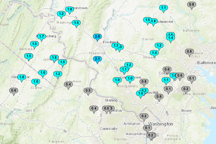
By 9 a.m. the snow had mostly tapered off in Maryland north of the Capital Beltway. Over an inch had fallen in Frederick and Montgomery counties, leading to slow travel. With temperatures warming above freezing, NBC Washington meteorologist Chuck Bell said most of the region apart from higher elevations can now expect a steady, chilly rain through Tuesday.
Several of the region’s largest school systems, including Montgomery and Loudoun county public schools, opted to cancel classes. For more, see WTOP’s closings and delays page.
- Listen to WTOP online and on the radio at 103.5 FM or 107.7 FM.
- Current traffic conditions
- Weather forecast
- Closings and Delays
- Sign up for WTOP email alerts
- Get custom alerts with the WTOP app for Apple and Android phones
In Maryland, a winter weather advisory advisory remains in effect for Montgomery, Frederick, Howard and Baltimore counties until 1 p.m. In Virginia, portions of Fauquier, Loudoun and northern Prince William counties are included in the advisory.
Most of Maryland west of the I-95 corridor and Virginia north of I-66 received at least an inch of snow by mid-morning according to the National Weather Service, with the highest amount of 2 inches observed in the city of Frederick. See the latest snow totals.
The District saw a trace — a brief burst of snow before daybreak put a fine coating on the ground outside the WTOP newsroom in Friendship Heights, but didn’t amount to much more than pretty photos and a travel headache once the sun came up.
The above/below freezing line remains draped right across the DMV. Fortunately, where it’s coldest across Northern Maryland, the snow has stopped. The entire area will be well above freezing by noon. All precip will be RAIN later today, tonight & Tuesday. pic.twitter.com/84MHzzbxqD
— Chuck Bell (@ChuckBell4) December 16, 2019
Temperatures will warm as the morning goes on, and any remaining snow bands will transition to a steady rain by noon Monday. That on its own could hamper travel throughout the area for afternoon and evening commute.
“Heavy rains will cause more problems because your tires can begin to hydroplane like water skis,” Montgomery County Fire and Rescue spokesman Pete Piringer tweeted, adding that fire officials had already responded to a few crashes involving wet or icy conditions.
“In this case, the key to keeping your tires in contact with the road is to simply slow down,” he said.
For the latest road and traffic conditions, see WTOP’s traffic page or listen to updates every 10 minutes online or on the air at 103.5 FM. Submit traffic tips by calling 866-304-WTOP or tagging @WTOPtraffic on Twitter.
Forecast:
Monday: Wintry mix transitioning to rain in all areas by noon. Highs in the mid to upper 30s.
Monday night: Rain. Highs in the mid to upper 30s.
Tuesday: Rain, ending around sunset. Becoming windy through the evening. Highs in the upper 40s to low 50s.
Wednesday: Partly cloudy and blustery. Colder, with highs in the upper 30s to low 40s.
Thursday: Sunny, breezy and cold. Highs in the low to mid 30s.