


The worst of the rain and flooding is over in the D.C. area, but the water is receding very slowly, showers are lingering and dangers remain after a torrential rainstorm Monday morning left roads flooded, drivers stranded and several Metro stations a mess.
The National Weather Service at 1 p.m. lifted the Flash Flood Warnings that had been in effect for the D.C. metro area for most of the morning, but they’ve been replaced by regular Flood Warnings, which will last until 9 p.m. in D.C.
That only means that “the floodwaters are not rising rapidly anymore … but the flooding is still there,” said Storm Team4 meteorologist Matt Ritter. Waters can still continue to rise, he said; just not as rapidly as in the morning.
“The areas that are still seeing problems, [they] will continue for the rest of the afternoon into the evening rush,” Ritter added.
Speaking of the evening rush, D.C.’s Homeland Security and Emergency Management Agency at about 3:45 p.m. released a list of closed roads in the District:
- Canal Road Northwest between Foxhall Road and Chain Bridge Road
- Arizona Avenue Northwest between Canal Street and MacArthur Boulevard
- The 4700 block of South Capitol Street Southeast
- The 1800 block of Kalorama Road Northwest
- Northbound I-395 at the 7th Street ramp
Downed power lines are a problem across the area, and Pepco reminds residents to treat all lines as live and dangerous.
Reagan National Airport reported 3.3 inches of rain in an hour, including a half-inch of rain in 11 minutes, on Monday morning. Between 3 and 6 inches of rain had fallen in Montgomery County by 11 a.m.
National Weather Service meteorologist Cody Ledbetter said the storm dumped about 6.3 inches of rain near Frederick, Maryland, about 4.5 inches near Arlington, Virginia, and about 3.4 inches at Ronald Reagan Washington National Airport in a two-hour period.
“The storm was not moving very quickly,” Ledbetter said.
Water levels at Cameron Run in Alexandria, Virginia, a flood-prone area along the Capital Beltway, rose more than 7 feet over 30 minutes after 9 a.m., according to the weather service. Four Mile Run, which runs through Arlington and Alexandria, saw a similar increase.
Many roads were closed in the area, including the Clara Barton Parkway, Canal Road in D.C. and more, and some still are. Check the list.
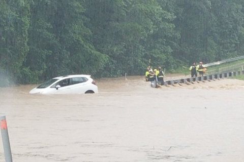
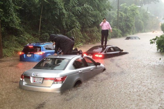
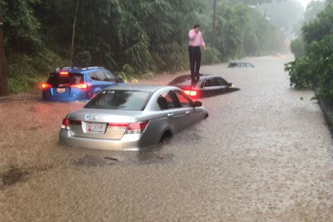
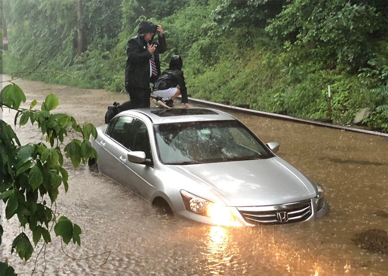
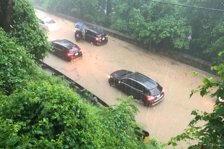
Hundreds of cars are stranded on a flooded George Washington Parkway. Cascading water is causing mass transit chaos. Stretches of King Street in Old Town Alexandria are underwater, with people wading through knee-high muck.
The National Weather Service issued a Flash Flood Emergency — a rare warning reserved for exceptionally severe and life-threatening urban flood events — Monday morning; it expired later in the morning. “IMMEDIATE ACTION IS REQUIRED TO SAVE YOUR LIFE!,” the weather service said, in an all-caps alert.
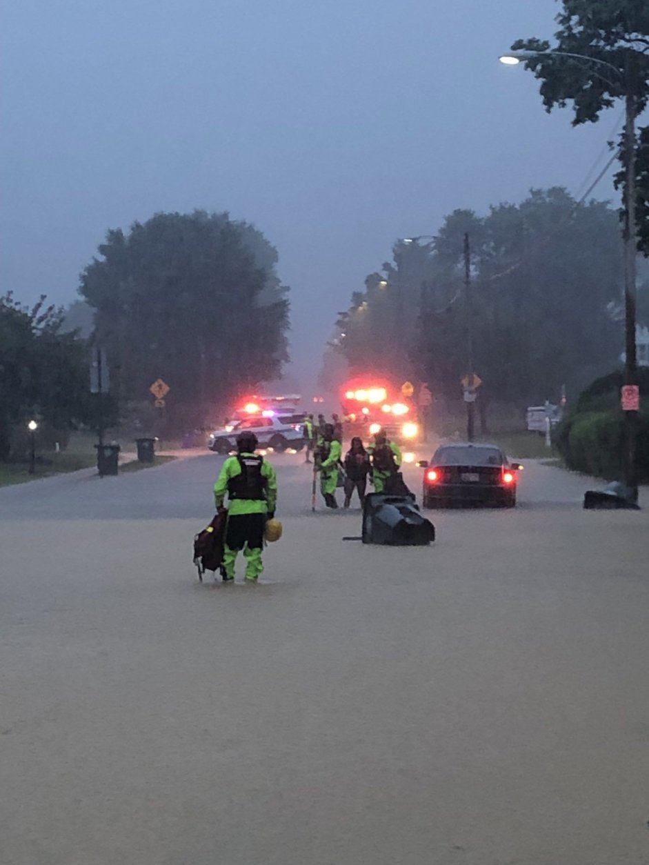
The D.C. Fire Department said they rescued 15 people from their cars Monday; Arlington County reported 38, as well as 27 from houses and apartments; Montgomery County rescued about two dozen from vehicles, said fire department spokesman Pete Piringer.
At about 12:30 p.m., Piringer stood on Coach Street, in the River Falls area of Potomac, Maryland, and said, “There are fences where fences usually aren’t, and fences are missing where they usually are.” Cars were in the middle of the road, where some had been flooded up to their roofs.
Taylor Blunt, with the Arlington County Fire Department, said that while the roadways were starting to clear as of 11:10 a.m., road debris and stranded cars were posing a new challenge.
Scary exit from the parking garage under the Capitals Ice Rink / Ballston Commons Mall in Arlington. The bottom level is a River! @WTOP @WTOPtraffic @ABC7News pic.twitter.com/exleKNbpEw
— Wendy Marco (@WendyMarco924) July 8, 2019
‘It happens in a hurry’
WTOP’s Dave Dildine has covered flooding before, including the devastation in Ellicott City in 2016 and 2018, but speaking about the water rescues he saw on Canal Road in Northwest D.C. Monday morning, he said he is still “totally surprised by how quickly this occurs. … It was beyond dramatic; it was downright scary.”
The term “flash flooding” is no joke, he said. “It really happens in a flash, and that’s why it’s so dangerous. … When runoff starts going, it happens in a hurry.”
And then, “Just as fast as [the water] rose, it receded,” he said. As he spoke, he noted that more rain was beginning to fall.
Those who were stranded are being safely escorted off of Canal Road by @dcfireems. Everyone else swam or walked to higher ground on their own. Water slowly receding now. Flash Flood Warnings are a big deal. #DCWX pic.twitter.com/ry80Ls1hfg
— Dave Dildine (@DildineWTOP) July 8, 2019
In Frederick, Maryland, a 50-year resident told WTOP’s Nick Iannelli that the flooding was “the worst I’ve seen it,” and described “river after river after river overflowing.” In Baker Park, Iannelli said, the water reached up to the seat of a park bench, and halfway up a soccer goal. The police were telling people to stay off the roads if at all possible, and releasing lists of flooded roads, “but they can’t keep up.”
Various flood-related issues were reported on both the inner and outer loops of the Capital Beltway. The Clara Barton Parkway disappeared under muddy waters. Reports of water rescues from inundated vehicles became so frequent for a time, they were difficult to keep track of.
“It only takes a couple of inches of moving, swift water to move your car out of the way,” Piringer told WTOP at about 1:30 p.m. It’s not just that you don’t know how deep the water is, he said; you don’t know the condition of the road underneath.
Threats remain
The worst of the rain may have passed, but the threat of flooding remains. Storm Team4 meteorologist Mike Stinneford told WTOP Monday morning that the heaviest storms headed south.
“All of this [water] has to go somewhere,” he said; “It’s going to take a while for this to run off.” Rock Creek could see a rise of several feet as the day moves on, he added.
Meanwhile, storms headed to the St. Charles area of southern Maryland, packing wind gusts of about 40 mph, Stinneford said.
Downed trees and mudslides are also impacting commutes and causing dangerous situations around the region. Thousands are experiencing power outages.
- Listen to WTOP online and on the radio at 103.5 FM or 107.7 FM.
- Current traffic conditions
- Weather forecast
- Sign up for WTOP alerts
“It’s important for motorists not to drive through standing water,” D.C. Mayor Muriel Bowser told WTOP. “Give our crews the road to work.”
Bowser said residents should report standing water to 311, and any emergencies to 911. If you have any choice, “Try to stay put,” she said. Anyone already out should plan ahead for their evening commute, the mayor said; District authorities will post on social media when they know what to expect on the roads as water recedes.
The Metro was hit hard in the middle of morning rush hour. Videos posted to social media appeared to show water bursting through the roof of the Virginia Square-GMU Metro station and pouring down the elevator shaft at Pentagon Metro.
Hey, @EENewsUpdates, I think I’m going to be late for work. @wmata pic.twitter.com/wg2ycFOp3L
— Niina H. Farah (@niina_h_farah) July 8, 2019
In Bethesda, an NBC Washington photographer witnessed a father rescue his daughters from rising floodwaters.
NBC Washington meteorologist Chuck Bell said early Monday that a recent run of “several good soakings, the soil is fairly saturated,” which created prime conditions for flooding.
Foul weather will taper off by Monday evening as a frontal boundary moves south, taking the rain along with it. Tuesday and Wednesday will be more reliably dry but hot, before another disturbed weather pattern moves in late this week.
All eyes turn to the south next weekend, where forecast models are hinting at a possible tropical cyclone in the Gulf of Mexico.
Long-range forecasts are hardly a given, but any storm that does develop in the Gulf will need to be monitored for weather impacts in the D.C. region early next week.
Closures and damages
The U.S. National Archives tweeted that flooding caused electrical issues in the main power vault, knocking out power throughout the building.
The building is equipped with flood walls which successfully deployed and protected the one-of-a-kind artifacts and documents — including the Declaration of Independence — that are housed inside the Archives building.
The Archives building will be closed Tuesday, July 9, while crews conduct repairs. There will also be no shuttle service to the National Archives in College Park, Maryland.
Maryland resident Jeremy Gagliardi told WTOP that the basement at his mother’s house on Coach Street in Potomac, Maryland, filled with flood water and two cars parked in the driveway floated out towards the street.
“Both engines are full of mud,” Gagliardi said. “There was a truck behind us … that ran into the flood and before he could pull backwards he floated all the way to the front of our mailbox — he had to climb out the window.”
Gagliardi said flood water quickly overwhelmed the neighborhood’s storm drains and began to fill the local pool.
Forecast:
Monday: Showers and a few thunderstorms, tapering off this afternoon. Rain may be heavy at times.
Highs: Upper 70s to low 80s
Monday night: Partial clearing. Areas of fog developing. Cooler and less humid.
Lows: Lower 60s to near 70
Tuesday: Becoming mostly sunny and a bit less humid.
Highs: Mid to upper 80s
Wednesday: Mostly sunny.
Highs: Mid to upper 80s
Thursday: Partly cloudy with scattered late afternoon thunderstorms.
Highs: Mid to upper 70s