WASHINGTON — Florence is now a Category 1 hurricane, the National Hurricane Center announced in an 11 p.m. update.
The hurricane is about 60 miles from Wilmington, North Carolina, with maximum sustained winds at 90 mph, and is expected to make landfall near the city on Friday.
More weakening is expected to happen as the storm moves farther inland, the center said, but storm surge and hurricane-force winds are already affecting parts of North Carolina.
“There is no power. I’m looking out a fourth floor balcony back to the center of Morehead City, and the lights are out. You go the other direction east toward Atlantic Beach — it’s all dark,” said WTOP’s Steve Dresner, who is in Morehead City, North Carolina.
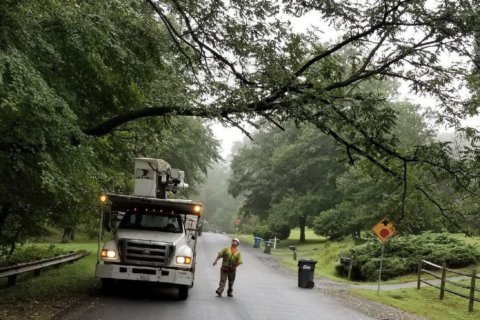
Tens of thousands are without power in North Carolina; Dresner said there was also a brief tornado warning Thursday night.
- WTOP Weather Center
- WTOP Traffic Center
- Current Weather Radar
- Severe Weather Map
- Listen Live to WTOP
- Get WTOP Alerts
In an update just after 10 p.m., Dresner said the eye of the hurricane could be moving over his area. And while it stopped raining temporarily, Dresner said the storm surge and wind were major concerns.
Outside the NWS Newport/Morehead City at 930 pm. pic.twitter.com/tErYVLRYQd
— NWS Newport/Morehead (@NWSMoreheadCity) September 14, 2018
“Life-threatening storm surge, heavy rainfall and damaging wind will cover a large area regardless of exactly where the center of Florence moves,” National Hurricane Center forecasters said.
“The biggest problem with this hurricane will be the water,” said the center’s Dennis Feltgen. “That’s where we have 90 percent of hurricane-related deaths.”
By the time Florence moves through early Saturday, it will leave heavy rain totals in its wake, forecasters said.
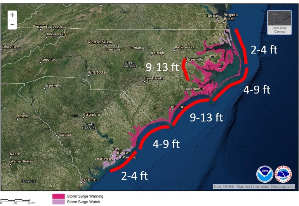
The storm surge will be near and to the right of where the eye of the hurricane makes landfall. The worst of the surge amounts predicted along the North Carolina coastline are 9 to 13 feet above ground, Feltgen said.
WHAT TO KNOW ABOUT FLORENCE
As of 11 p.m., maximum sustained winds were at 90 mph with higher gusts.
The center expects little change in Florence’s strength before the hurricane’s eye reaches the coast. After the eye moves inland, it is expected to weaken.
“Damaging hurricane-force winds are likely along portions of the coasts of South Carolina and North Carolina,” center forecasters said. “Damaging winds could also spread well inland into portions of the Carolinas and Virginia.”
The center said a WeatherFlow station at Fort Macon, North Carolina reported a sustained wind of 77 mph, with a higher gust up to 100 mph.
A National Weather Service office in Morehead City, North Carolina, recorded a storm surge of 10 feet above normal levels.
Tornadoes are possible in eastern North Carolina through Friday.
Florence’s expected slowdown means a prolonged period near the coast, said the hurricane center’s Joel Cline. It could then head west and southwest.
The result: prolonged storm surge, wind and rain.

HOW MUCH RAIN COULD THE CAROLINA COAST SEE?
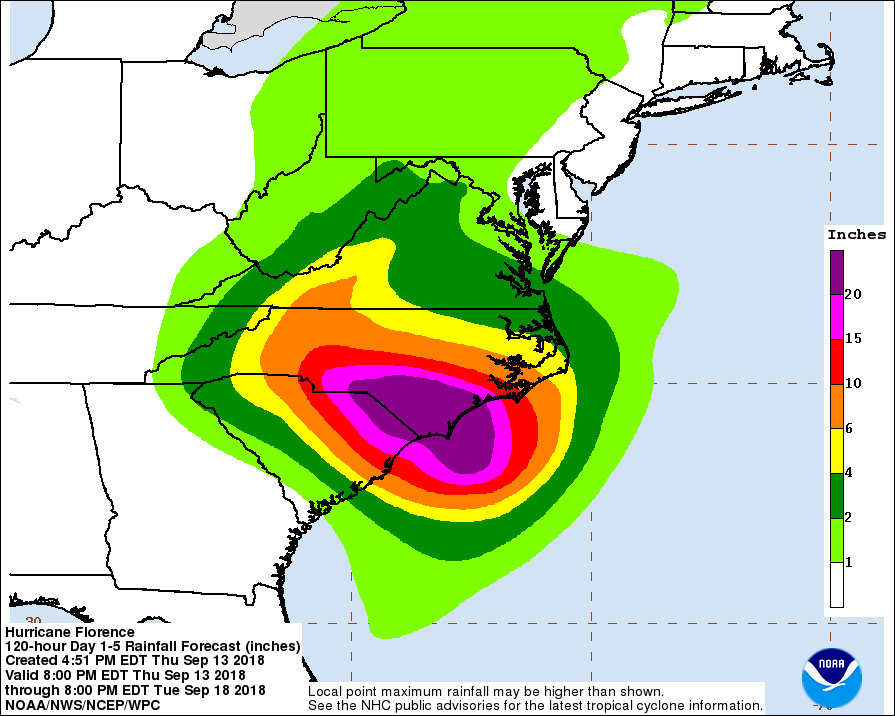
The storm could dump 20 to 30 inches of rain along the Carolina coast and up to 12 inches inland. Isolated areas could get 40 inches.
The impact is expected to be similar to that of Hurricane Harvey on the Houston area last year, Feltgen said.
“Those outer bands are just as destructive as areas that come close to the walls, so it’s going to be a very long overnight for a lot of people between Virginia all the way down to Georgia,” Dresner said.
The expected heavy rainfall would produce both flash flooding and river flooding that could in turn cause an environmental disaster, if the water inundates the region’s many industrial waste sites and hog manure ponds.
“Because of the slow movement of the storm, the rain is going to have plenty of time keep piling up,” said Feltgen.
And as the storm pushes inland, it could dump 6–10 inches as far inland as Charlotte and Raleigh in North Carolina as well as in Roanoke, Virginia, he said.
IN THE CAROLINAS, A STARK PICTURE
In Morehead City, Dresner said people are ready for what’s to come. “There’s nothing open. Places have been boarded up,” he said, adding that there are plenty of supplies such as gas and water for those who have opted to stay.
Not far away in Wilmington, ABC correspondent Jim Ryan said a local Waffle House that has remained open has been doing good business.
“It was packed this afternoon with people going in there,” Ryan told WTOP’s Shawn Anderson and Hillary Howard. “Waffle House has vowed that they’ll try to keep the place open for as long as the powers on. So far, the power is on — Waffle House is open.”
In Myrtle Beach, ABC correspondent Pete Combs painted a starker picture of those who decided to stay in place. He said only about 300,000 of the 700,000 people who live in the mandatory evacuation zone have left.
“They refuse to evacuate,” said Combs of a friend who lives a mile out from the beach. “They pulled out all the furniture out of the yard. They have boarded up a couple of windows.”
But, knowing the intensity of Florence’s impact on Myrtle Beach, “My friends are worrying me right now,” Combs said.
Officials said people refusing to evacuate could end up alone, drenched and in the dark, as rescue crews won’t go out to help in winds above 50 mph. Two amphibious Navy ships are on standby to respond and provide disaster relief after Florence moves through.
Get live views from web cams along the coast.
IN VIRGINIA, ‘THREAT WILL CONTINUE’
Virginia remains under a state of emergency.
The southern portion of the Virginia coast is under a tropical storm warning — from north of Duck, North Carolina, to Cape Charles Light, Virginia, and the Chesapeake Bay south of New Point Comfort.
After it weakens inland, Florence is predicted to turn northward, raising concern about how additional rainfall — even from a significantly weakened storm — will impact the southwestern portion of the commonwealth, which is already water-logged.
High winds and downed power lines are another concern for that region.
“This threat will continue into next week,” said Jeff Stern, Virginia’s state coordinator of emergency management, during a Thursday evening news conference.
About 400 Virginians are in shelters, Stern estimated.
Virginia Gov. Ralph Northam reminded residents to stay off the roads and shelter in place. “Now is not the time to let down our guard,” he said.
Maryland, too, remains under a state of emergency.
But, on Thursday evening, D.C. Mayor Muriel Bowser rescinded her earlier state-of-emergency order for the District.
FORECAST
Thursday night: Showers, areas of fog and drizzle; lows in 60s
Friday: Sometimes-heavy showers; highs around 80
Saturday: Breezy with bands of mainly light showers; highs in low to mid-80s
Sunday: Breezy and a few showers; highs in lower 80s
Monday: Breezy; remnants of Florence may bring heavy rain late in the day; highs around 80
BE PREPARED
- Have at least three days of food, water and medicines on hand
- Charge phones
- More preparation tips and a checklist
- Sign up for alerts and apps
- Maryland Prepares mobile app, with real-time local information, is available for both Android and iOS phones.
- Virginia residents can sign up for state-issued emergency email alerts.
- D.C. residents can sign up for city alerts.
CURRENT CONDITIONS
WTOP staff and The Associated Press contributed to this report.