Workweek weather: Hot weather rolls in for weekend after pleasant week

These graphics show the output from the GFS computer model for afternoon temperatures across the country. Over the course of the workweek, the cooler-than-average temperatures in the Northeast and Mid-Atlantic move out. Cooler weather returns to the Northwest and some of the hot weather of the West will shift into the D.C. area.
(Data: Environmental Modeling Center, NOAA |  Graphics: Storm Team 4)
These graphics show the output from the GFS computer model for afternoon temperatures across the country. Over the course of the workweek, the cooler-than-average temperatures in the Northeast and Mid-Atlantic move out. Cooler weather returns to the Northwest and some of the hot weather of the West will shift into the D.C. area. (Data: Environmental Modeling Center, NOAA | Graphics: Storm Team 4)
Most of the week, dew point temperatures will be in the 40s and 50s, meaning there won't be a lot of moisture in the air. That, of course, means even when it's warm, it will feel dry. It's not until the end of the week that the dew points will start climbing back up to uncomfortable levels. Remember, the higher the dew point, the more moisture there is in the air. (WTOP/Storm Team 4)
Most of the week, dew point temperatures will be in the 40s and 50s, meaning there won’t be a lot of moisture in the air. That, of course, means even when it’s warm, it will feel dry. It’s not until the end of the week that the dew points will start climbing back up to uncomfortable levels. Remember, the higher the dew point, the more moisture there is in the air. (WTOP/Storm Team 4)
Despite the lack of big weather events, it's actually going to be quite comfortable for most of the workweek.
 (WTOP/Storm Team 4)
Despite the lack of big weather events, it’s actually going to be quite comfortable for most of the workweek. (WTOP/Storm Team 4)
Lastly, there will not be much rain this week. Without much moisture in the air, Tuesday's front won't have much to work with. In this graphic, most of the cumulative rainfall for the week projected by the Weather Prediction Center for the D.C. area will be when it's getting more humid by the end of the week. Most of the rainfall depicted for the Midwest will also be toward the end of the week. The data is valid from this past Sunday evening until this coming Friday evening. (Weather Prediction Center, NOAA)
Lastly, there will not be much rain this week. Without much moisture in the air, Tuesday’s front won’t have much to work with. In this graphic, most of the cumulative rainfall for the week projected by the Weather Prediction Center for the D.C. area will be when it’s getting more humid by the end of the week. Most of the rainfall depicted for the Midwest will also be toward the end of the week. The data is valid from this past Sunday evening until this coming Friday evening. (Weather Prediction Center, NOAA)
(1/8)
These graphics show the output from the GFS computer model for afternoon temperatures across the country. Over the course of the workweek, the cooler-than-average temperatures in the Northeast and Mid-Atlantic move out. Cooler weather returns to the Northwest and some of the hot weather of the West will shift into the D.C. area.
(Data: Environmental Modeling Center, NOAA |  Graphics: Storm Team 4)
Most of the week, dew point temperatures will be in the 40s and 50s, meaning there won't be a lot of moisture in the air. That, of course, means even when it's warm, it will feel dry. It's not until the end of the week that the dew points will start climbing back up to uncomfortable levels. Remember, the higher the dew point, the more moisture there is in the air. (WTOP/Storm Team 4)
Despite the lack of big weather events, it's actually going to be quite comfortable for most of the workweek.
 (WTOP/Storm Team 4)
Lastly, there will not be much rain this week. Without much moisture in the air, Tuesday's front won't have much to work with. In this graphic, most of the cumulative rainfall for the week projected by the Weather Prediction Center for the D.C. area will be when it's getting more humid by the end of the week. Most of the rainfall depicted for the Midwest will also be toward the end of the week. The data is valid from this past Sunday evening until this coming Friday evening. (Weather Prediction Center, NOAA)

WASHINGTON — Oftentimes, meteorologists talk about summer doldrums, implying that the weather won’t be changing much day to day in a certain pattern. But that’s usually a hazy, hot and humid pattern in which there’s rarely anything happening except pop-up thunderstorms in the late daytime heating. Not this week.

Despite the lack of big weather events, it’s actually going to be quite comfortable for most of the workweek. It will also be a great time to be outdoors for work and play, including the Nationals’ continued homestand, this time four games against the Cubs, Monday through Thursday.

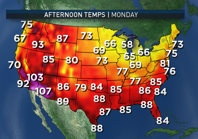
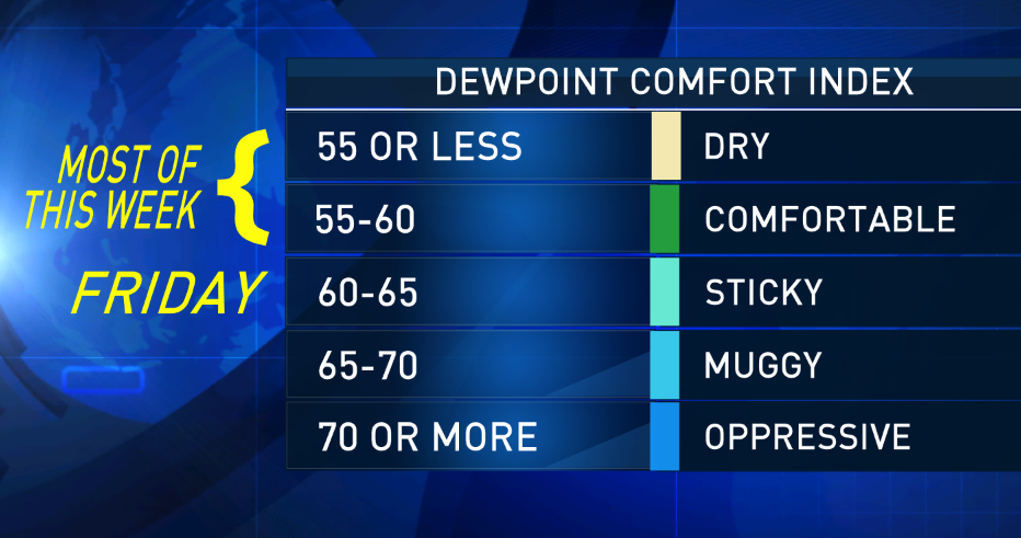
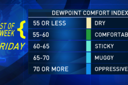
High pressure building into the southeast U.S. will already be bringing us mostly clear skies to start out Monday. With mostly westerly flow, the dry weather we had on Sunday will continue. Without enough moisture for the atmosphere to lift during the daytime heating, we’ll not see much more than fair weather cumulus clouds the rest of the day. Temperatures will be close to seasonable averages, but the humidity will be in the comfortable range. (In fact, it’s really not until the end of the week that it will start to feel muggy or even just sticky.)

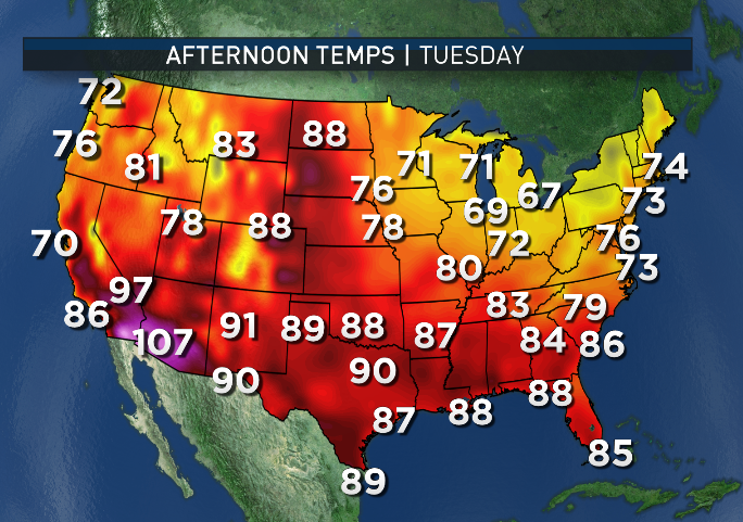
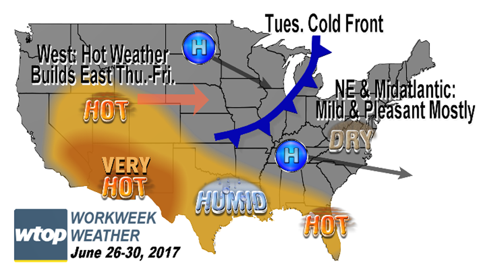
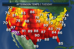
A new area of high pressure coming from central Canada will push a weak, decaying cold front through the area on Tuesday with nothing more than a few hours of clouds and a chance of showers, especially in northern Maryland up into central Pennsylvania. With the clouds and the cooler air behind the front, some spots of northern Maryland and West Virginia may not make it out of the 70s for highs.

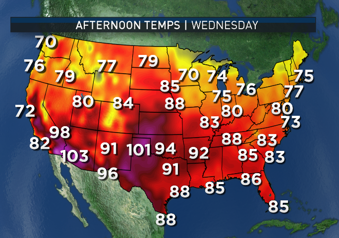
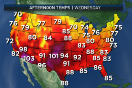
So, the D.C. area and everyone else getting to right around 80 is still considered below average. The dry air, clear skies and calming breezes will ensure a very cool Wednesday morning, and some of the far northern and western suburbs conceivably could end up in the upper 40s. However, most of us will only bottom out in the low to mid 50s, still giving a rest to the air conditioners. Wednesday will be the best day of the week with the high pressure center directly overhead. We should have almost full sunshine, seasonable temperatures and continued low humidity.

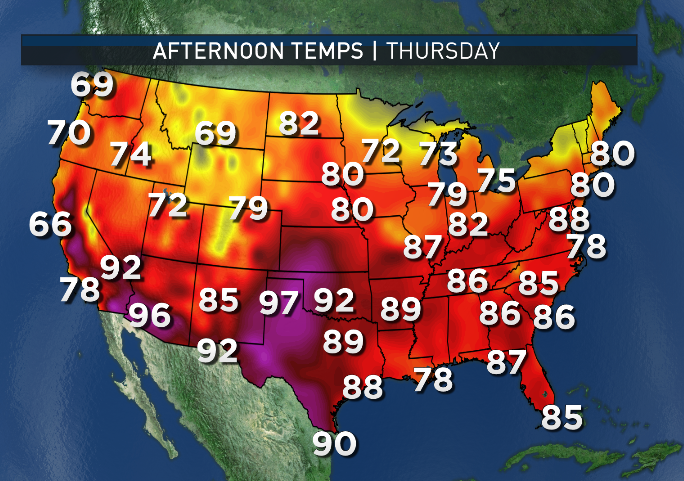
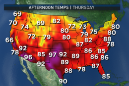
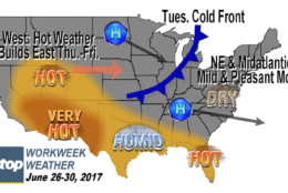
But the rest of the week will have the ridge of high pressure shifting just off the eastern seaboard, setting us up for a southwesterly flow in the jet stream winds and at the surface. That means some of the extreme heat that’s been in the West and the humidity near the Gulf Coast will start heading back here. No, the region won’t be getting the extreme heat of the Southwest that has made recent news headlines, just typical D.C.-area summertime hot weather.

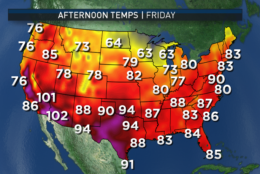
By Friday especially, it will start getting uncomfortably humid again.

This pattern shift will be another “Bermuda high” and we may have a new heat wave starting for the weekend.

Daily weather highlights 

MONDAY
— Cool and comfortable start
— Lots of sunshine mixed in with fair weather clouds
— Low humidity

TUESDAY
— Some sun early then increasing clouds
— A bit breezy
— An isolated shower or a few scattered showers/thunderstorms, most likely north of D.C.
— Cooler than average temperatures, especially in the northern and western suburbs
— Cooling off quickly after sunset

WEDNESDAY
— Very cool start, especially in the suburbs
— Warming up quickly after sunrise, but staying slightly below average
— Almost total sunshine all day

THURSDAY
— High-level clouds, otherwise mostly sunny
— Heating up again, near the 90-degree mark
— Humidity creeping up again, but still tolerable for most folks

FRIDAY
— “The three Hs” return: hazy, hot and humid
— Most spots in the low 90s
— Humidity back to borderline sticky and muggy levels
— A slight risk of a late-day thunderstorm


Editor’s Note: The WTOP Workweek Weather Blog is intended as an in-depth yet plain language summary of the business week’s weather potential in the D.C. area along with an explanation of the contingencies and uncertainties that exist at the time of publication. For the latest actual Storm Team 4 forecast, check out the main WTOP Weather Page.

Federal News Network Logo
Log in to your WTOP account for notifications and alerts customized for you.

Sign up