WASHINGTON — It’s been discussed for several years, and now the state of Maryland and the Federal Highway Administration are conducting a $5 million study to look at where a new Chesapeake Bay Bridge crossing might work best.
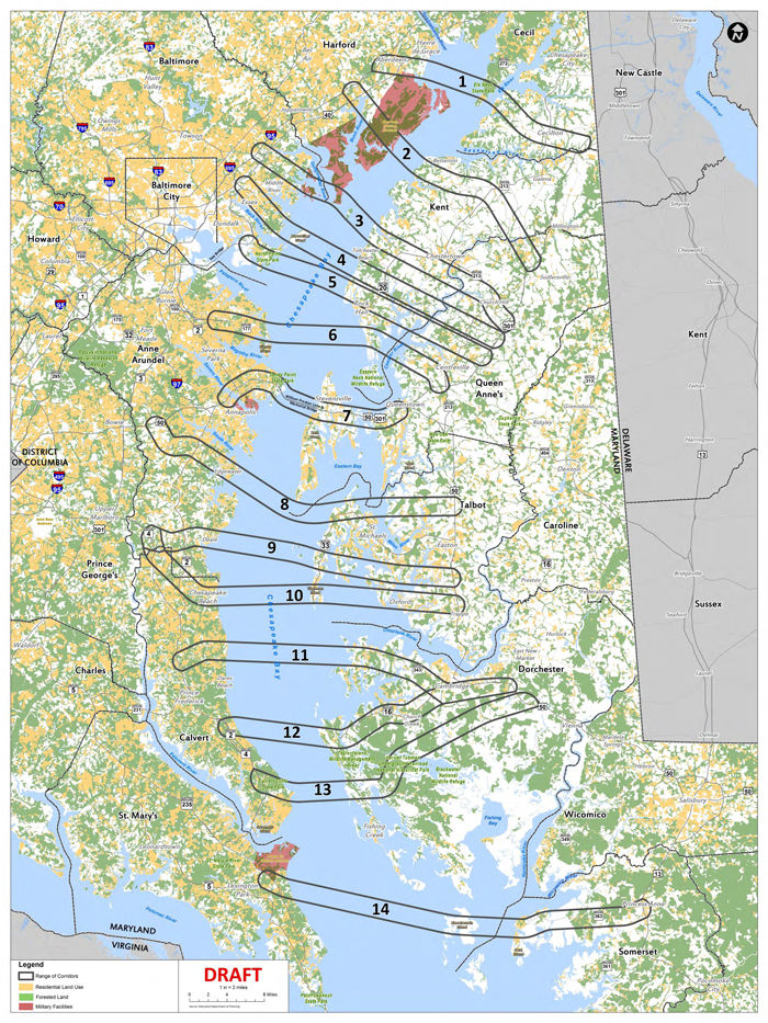
A map showing the different crossings was released by Delegate Robin Grammer, a Baltimore County Republican with two potential crossings in his district. He says he’s in favor of discussing a new bridge, but not the two (options four and five) that would run from his district across the bay into Kent County.
This early in the process, there is a wide range of possibilities on the table, with different reasons for their impracticality. But those that seem more feasible may find other roadblocks instead.
“Folks are going to organize against this,” said Anne Arundel County Executive Steuart Pittman. The Democrat said, “this is a long term plan … and by the time this thing gets built, if we haven’t figured out how to get cars off of the roads, we’re in serious trouble. I think we need to be looking at public transportation and trains.”
Multiple routes being considered would go through Anne Arundel County, and many of those would cut through the southern half of the county over to Talbot County. But Pittman warned, “(If) you tell any of these communities along these routes that you’re going to stick a highway through them and take their coast and put a bridge off of it … you’re going to have a revolt on your hands.”
Here are the 14 options:
- Another bridge connecting Harford to Cecil County, but instead of crossing the Susquehanna River, it would run from around Aberdeen across Elk Neck State Park to around Cecilton.
- This span would run from south of Aberdeen in Harford County, across Aberdeen Proving Ground and into northern Kent County around Betterton.
- This span would run from north of the Middle River in Baltimore County to around the Tolchester Beach area of Kent County.
- Running from north of the Back River in Essex across Hart Miller Island into Kent County.
- Coming out of Dundalk and Sparrows Point, this crossing would take traffic close to Rock Hall, Maryland, in Kent County.
- Emerging west to east from Pasadena to south of Rock Hall, it would then send traffic over a new bridge across the Chester River toward Centreville.
- This option runs parallel with the current Chesapeake Bay Bridge.
- This span would seemingly extend Maryland Route 214 out of Edgewater and Mayo across the Bay past the southern tip of Kent Island, eventually onto the eastern shore in Talbot County.
- Another bridge then direct traffic toward U.S. Route 50 north of Easton by skipping across the Miles River north of St. Michael’s.
- This corridor would connect Deale with Tilghman Island and eventually take traffic to Route 50 south of Easton
- This span would start around North Beach in Calvert County and go across the southern tip of Tilghman Island before crossing over water again into Oxford. Traffic would ultimately feed on to Route 50 around Trappe, not far north of the Choptank River.
- This span runs east of Huntingtown in Calvert County and crosses into Dorchester County west of Cambridge.
- This crossing would start around Calvert Beach off U.S. Routes 2/4 and run over to Maryland Route 16 in Dorchester County, and like option 11, would wind its way through marsh land before hitting Route 50 in Cambridge.
- Running from around Calvert Cliffs into Dorchester County, it would be one of the shortest crossings on the table. But the roads it would link to on the eastern shore are mostly a mix of farm land and swamps.
- This crossing would start in Lexington Park in St. Mary’s County, running from just south of the Naval Air station eventually over to Deal Island in Somerset County. Traffic would hit U.S. Route 13 in Princess Anne, which is south of Salisbury.

No matter which route the state decides on, lawmakers representing Eastern Shore counties have the ability to veto the project on a majority vote. There’s a push this legislative session to give Anne Arundel County lawmakers any say over a project affecting that county. The other would give the entire legislature a say.
Pittman argues any of the 14 possibilities represent solutions that will be outdated by the time any bridge is actually built.
“I think it makes a lot more sense to be looking at trains that goes along the route … in the median of Route 50, potentially,” Pittman said. “That could go across where the bay bridge is.” He says a commuter line could then theoretically link up with other mass transit lines that already exist west of the bay.
“That makes a lot more sense as a long-term investment,” said Pittman.


