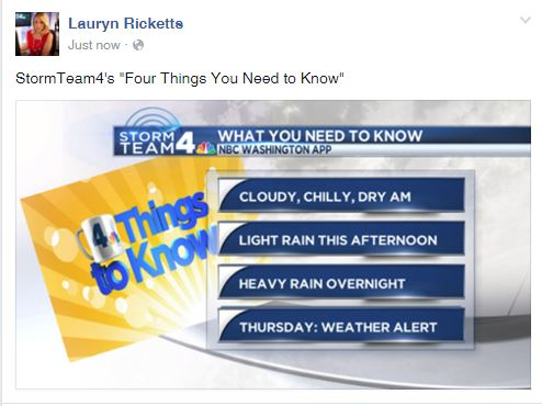
StormTeam 4’s Four Things You Need to Know
- A cloudy and chilly but dry Wednesday morning.
- Some patchy drizzle to light rain showers through the afternoon.
- Heaviest Rain Wednesday overnight through Thursday morning.
- Thursday: STORMTEAM4 Weather Alert Day.
You are going to want to grab the umbrella for Wednesday and Thursday and the winter jacket for the weekend. Yes, that is correct. Say goodbye to warm temperatures because it’s cooling down big time after Thursday, just in time for Saturday and Sunday.
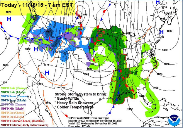
The same system that has caused a bevy of severe weather across the United States is headed this way. Winds will pick up through Wednesday afternoon as outgoing high pressure and incoming low pressure moving up the Mississippi Valley interact.
Eventually those breezy east to southeast winds will tap into some Atlantic moisture and bring it right into the region making way for some patchy drizzle and isolated light rain showers through the day on Wednesday.
More steady rain chances will increase through late Wednesday afternoon from the west to the east but most of the rain will arrive through the late evening. Temperatures Wednesday will top out in the lower 60s and will stay right around that 60 degree mark overnight.
Rain will continue overnight and could be heavy at times. In fact, heavy rain will continue to fall through the morning commute on Thursday morning, so be sure to pack your patience and possibly plan to leave a little early as there could be some problems on the roadways.
Dodging a few sprinkles/light showers today-steady rain filling in late this aft/evening. Heaviest rain Thurs. AM pic.twitter.com/CbEuhfjowm
— Lauryn Ricketts (@laurynricketts) November 18, 2015
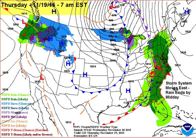
Rain will continue to move out of here through the midday on Thursday. Rain showers could linger just a little longer for areas around the Bay and continue into the mid- to late afternoon before it finally moves out of here.
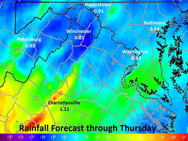
The good news is that the region could pick up a nice amount of rain that’s needed! The area is running a little over 2.5 inches below normal for rainfall amounts since Sept. 1. Any rain will be needed, but just not welcomed.
Temperatures will in fact rise through midday Thursday and into the early afternoon, topping out in the mid to upper 60s!
However, behind that front, winds will increase and temperatures will drop through the late afternoon. Under clearing skies and breezy winds, overnight low on Thursday will fall into the 40s.
By Friday, it will not make it out of the 50s for daytime highs, although the sunshine will return.
The weekend looks mighty chilly. Once the winds settle down on Friday night (just in time for Friday night football — but it will still be chilly!), Saturday will be the transition day.
Expect sunshine and temperatures in the low to mid 50s for daytime highs Saturday. Clouds will increase through the second half of Saturday as a Canadian front approaches the region. Right now it looks like the frontal passage will be dry, but it will bring another shot of cold air and some breezy winds. Winds will pick up Saturday overnight into Sunday morning with wind chills in the 20s!
Winds will continue to be breezy through the day on Sunday with daytime highs stuck in the 40s. The last time daytime highs were in the 40s was March 29, 2015, so I guess we are due!
Grab that winter jacket for the weekend and into early next week, you are going to need it.