Workweek weather: Summer heat returns — with humidity

WASHINGTON — It seems like in the summer, anytime we have a day or two of really nice weather, we have to pay for it with hot and humid weather a few days later. This week is no exception.

High pressure that brought a beautiful Sunday is heading out to sea, and the clockwise circulation around it on the other side will be pumping in hot weather for most of this week. Also, the flow will be tapping abundant moisture from the Gulf of Mexico, bringing the humidity back up to uncomfortable levels.

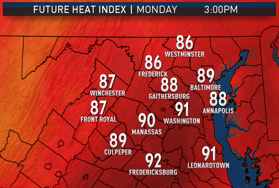
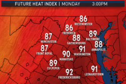
Monday will start out clear, calm, cool and comfortable for the morning commute. Full sunshine will warm temperatures up quickly and we will max out at close to seasonable levels in the afternoon. But clouds will be on the increase ahead of a weak warm front, which actually, for all intents and purposes, will be the leading edge of the increased humidity.

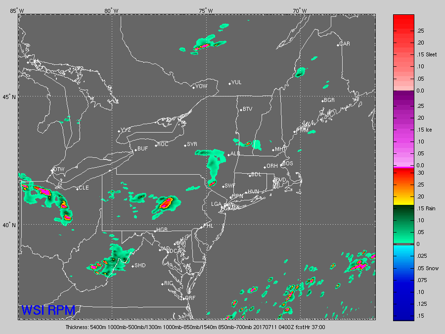
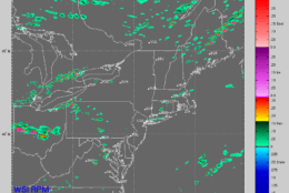
Some showers and thunderstorms will be moving into Ohio and West Virginia, but at this point, it’s unclear as to whether they will make it here; if they did, it wouldn’t be until evening.

It seems like in the summer, anytime we have a day or two of really nice weather we have to pay for it with hot and humid weather a few days later; and this week is no exception.
(Graphics: Storm Team 4)
It seems like in the summer, anytime we have a day or two of really nice weather, we have to pay for it with hot and humid weather a few days later. This week is no exception. (Graphics: WTOP/Storm Team 4)
These images show some computer-projected heat index values for 3 p.m. each day this week. The tropical-like humidity on Tuesday and Wednesday in particular could make the apparent temperature almost 10 degrees higher than what thermometers will be showing. The model is the high-resolution version of the American GFS. (Data: Environmental Modeling Center, NOAA. Graphics: Storm Team 4)
In these images, the high resolution RPM computer is depicting the future radars showing an organized complex of thunderstorms moving through the areas of West Virginia and Pennsylvania and heading toward us Monday afternoon, but never quite making it. Actual radar trends will have to be watched, but this scenario is reasonable. The third image shows isolated thunderstorms forming in the heat and humidity on Tuesday afternoon. It shows the random, hit-and-miss nature of isolated storms. They won’t occur precisely where depicted. (Data: The Weather Company. Graphics: Storm Team 4)
(1/9)
It seems like in the summer, anytime we have a day or two of really nice weather we have to pay for it with hot and humid weather a few days later; and this week is no exception.
(Graphics: Storm Team 4)

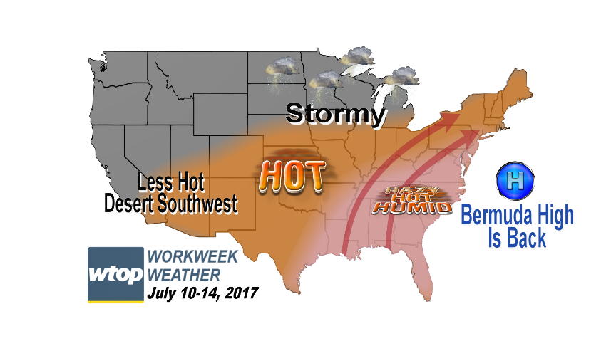
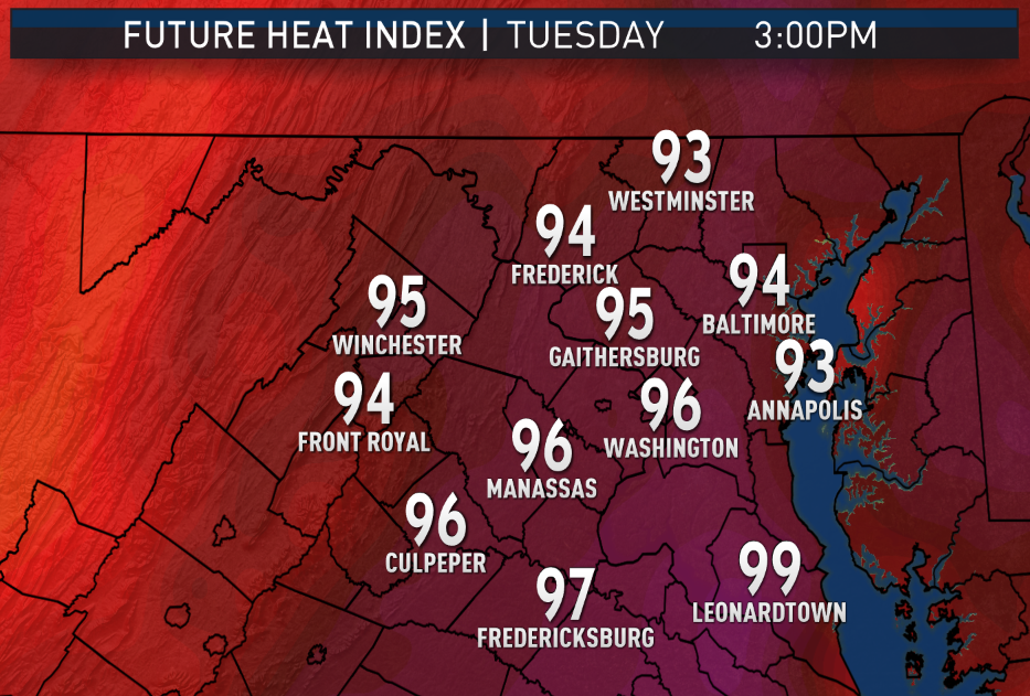
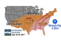
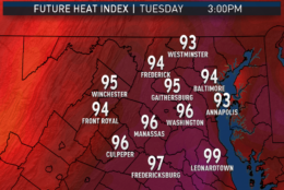
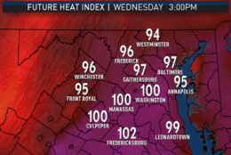
Tuesday through Thursday, we’ll be in the heart of the “Three Hs:” hazy, hot and humid. The strength of the Bermuda high will keep any weak fronts stalled to our north, so the only thunderstorms that will be able to pop up will be isolated, neighborhood-by-neighborhood, late-day storms.

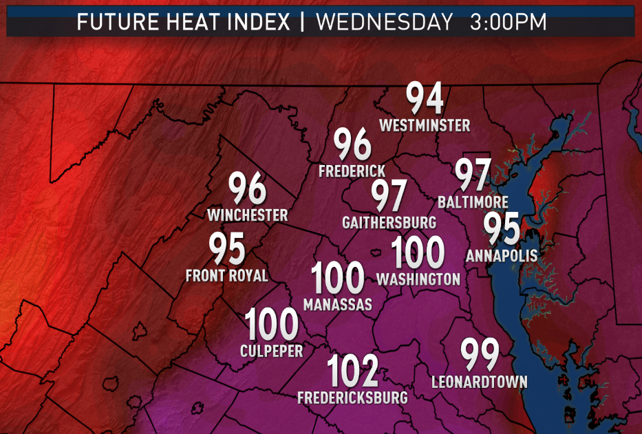
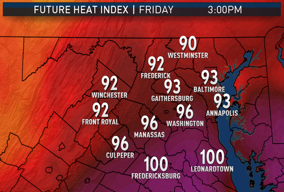
The most likely candidates will be areas near the higher elevations, where the terrain is heated unevenly, and close to the Chesapeake or even the beaches, where bay breezes and sea breezes will be possible. In the meantime, the cities will see temperatures climbing well into the upper 90s with heat index values near 100 if not a little above.

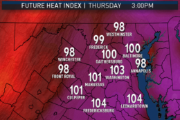
On Thursday, the next front will try to pass into the area but won’t make it all the way. It may increase the chances for, at most, scattered thunderstorms in the daytime heating.

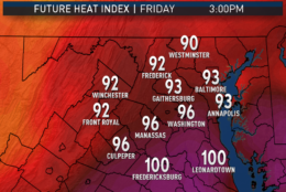
Friday does look like it will have the next real cold front passing through. Depending on the timing, we could see some strong storms with heavy rainfall. The front will break the heat wave, but barely — and make it more comfortable into the weekend.

Remember that the heat index is a temperature adjustment based on the humidity’s effect on the human body’s ability to maintain temperature. The higher the relative humidity — when dew points and temperatures get closer together — the less moisture (aka sweat) will evaporate off the skin. When moisture evaporates off the skin, it takes heat with it. So sweating is good, unless it can’t cool you down. When the body can’t regulate its temperature, heat-related illness can occur.

It should be noted that overnight lows this week may be very high in and of themselves. Many of the big cities may not drop below 80 degrees for morning lows. That’s also a result of the high humidity levels, since water vapor holds onto more daytime heat than dry air does.

Daily Weather Highlights 

MONDAY:
• Almost cool to start the day in rural locations, mild in the cities
• Full sunshine warming temperatures quickly in the morning
• A bit more cloudiness in the afternoon and into the evening
• Keeping an eye on storms far to our northwest for late evening

TUESDAY & WEDNESDAY:
• Hazy, hot and humid
• Partly sunny, lots of cumulus clouds
• Isolated, hit-and-miss thunderstorms in the afternoon and into the evening
• Heat Index near 100, if not a bit above, especially in the cities

THURSDAY:
• Hazy, hot and very humid
• More cloudiness
• Scattered afternoon and evening thunderstorms
• Heat index near 100

FRIDAY:
• Hot and humid
• Numerous thunderstorms potentially late in the day

Editor’s Note: The WTOP Workweek Weather Blog is intended as an in-depth yet plain language summary of the business week’s weather potential in the D.C. area along with an explanation of the contingencies and uncertainties that exist at the time of publication. For the latest actual Storm Team 4 forecast, check out the link on the main WTOP Weather Page.

Federal News Network Logo
Log in to your WTOP account for notifications and alerts customized for you.

Sign up