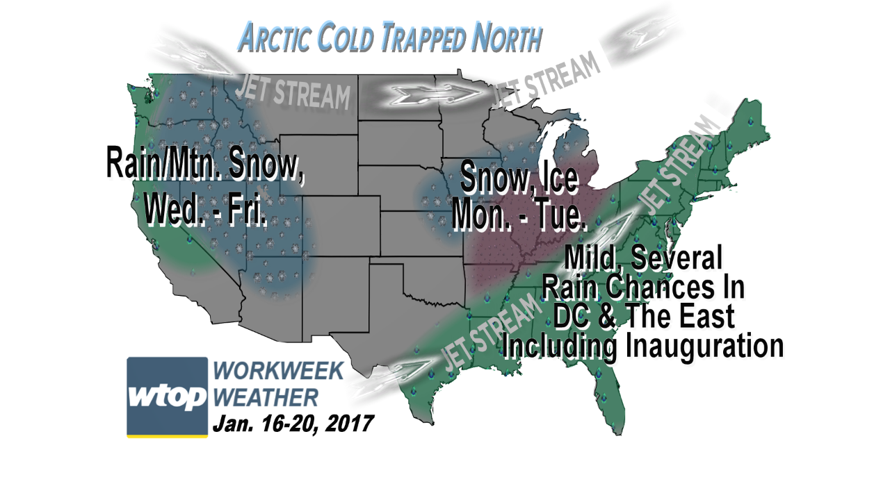
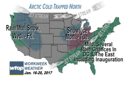
The workweek ahead will feature a few chances for umbrella use, but in this pattern there will not be a lot of available cold air to tap to bring any wintry precipitation.
The workweek ahead will feature a few chances for umbrella use, but in this pattern there will not be a lot of available cold air to tap to bring any wintry precipitation.
(WTOP/Storm Team4)
WTOP/Storm Team4
Starting with the daily temperatures in the GFS computer model to show that lack of Arctic air in the country, after it loses its grip on the middle of the country, where the ice storm was over the weekend.
(Data: Environmental Modeling Center, NOAA. Graphics: Storm Team4)
Data: Environmental Modeling Center, NOAA. Graphics: Storm Team4
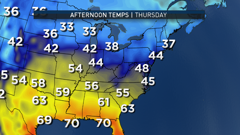
The warmest days will be in the middle of the week, behind the first warm front.
(Data: Environmental Modeling Center, NOAA. Graphics: Storm Team4)
Data: Environmental Modeling Center, NOAA. Graphics: Storm Team4
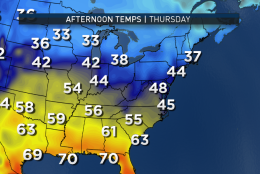
The model is likely under-doing the temperatures for Wednesday and some 60s will be possible, especially south of Washington. Cooler temperatures return for Inauguration Day Friday because of easterly flow and the rain.
(Data: Environmental Modeling Center, NOAA. Graphics: Storm Team 4)
Data: Environmental Modeling Center, NOAA. Graphics: Storm Team 4
The model is likely under-doing the temperatures for Wednesday and some 60s will be possible, especially south of Washington.
(Data: Environmental Modeling Center, NOAA. Graphics: Storm Team4)
Data: Environmental Modeling Center, NOAA. Graphics: Storm Team4
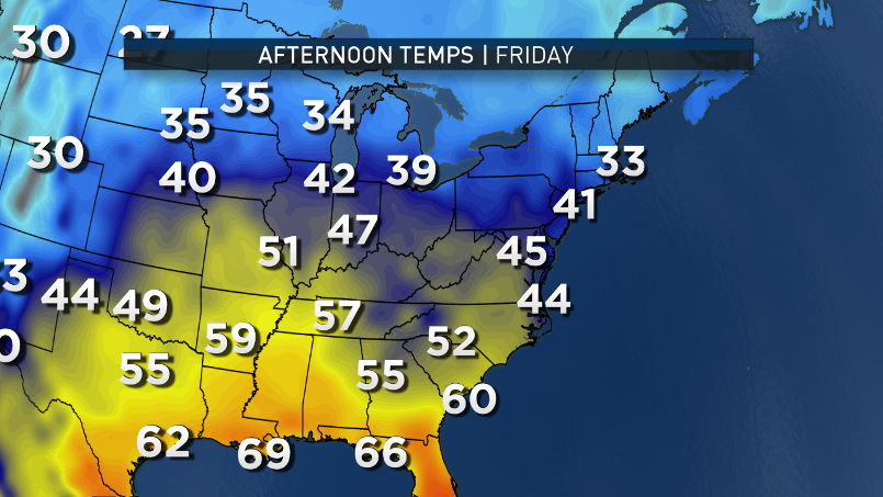
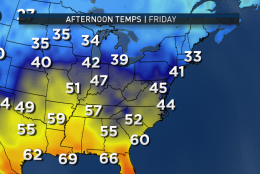
Cooler temperatures return for Inauguration Day Friday because of easterly flow and the rain.
(Data: Environmental Modeling Center, NOAA. Graphics: Storm Team4)
Data: Environmental Modeling Center, NOAA. Graphics: Storm Team4
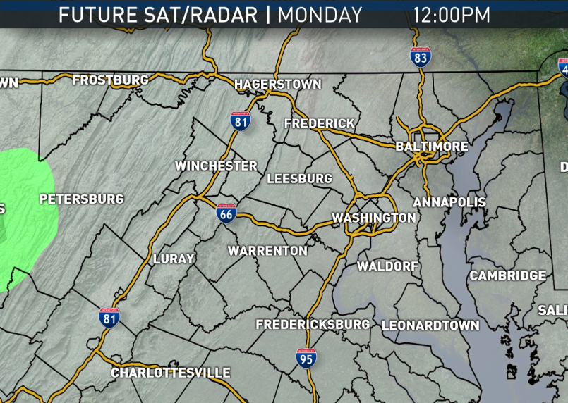
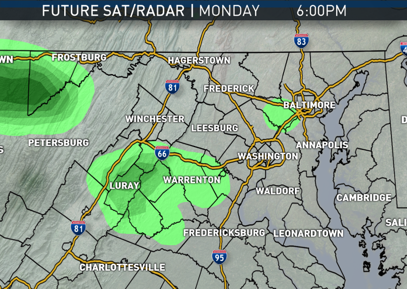
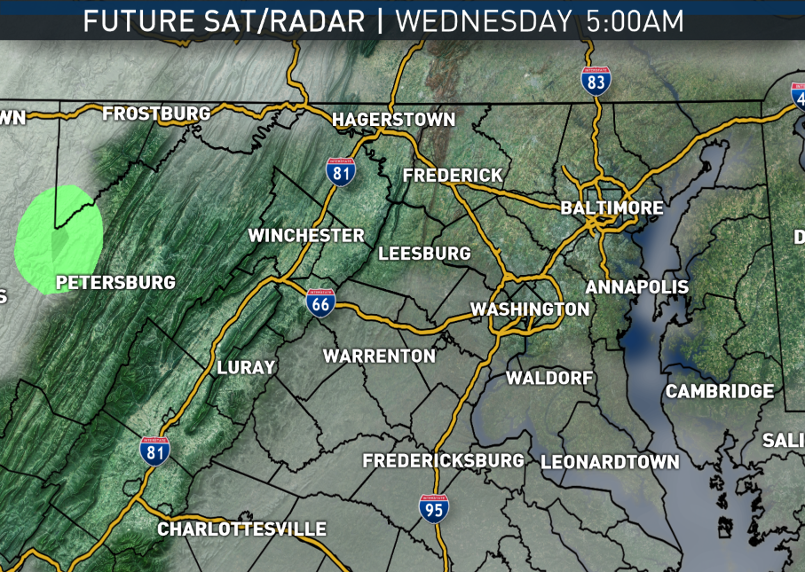
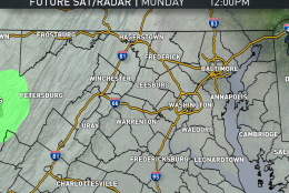
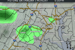
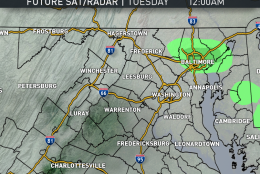
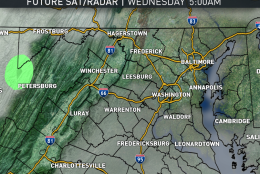
The RPM computer model shows the potential for light rain or drizzle on Monday through Monday night.
(Data: The Weather Company. Graphics: Storm Team4)
Data: The Weather Company. Graphics: Storm Team4
The RPM computer model shows the potential for light rain or drizzle on Monday through Monday night.
(Data: The Weather Company. Graphics: Storm Team4)
Data: The Weather Company. Graphics: Storm Team4
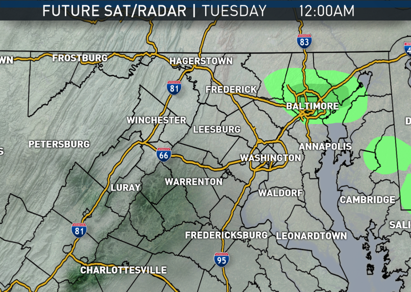
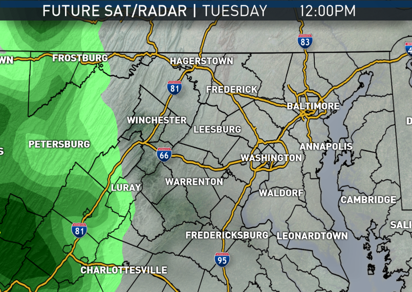
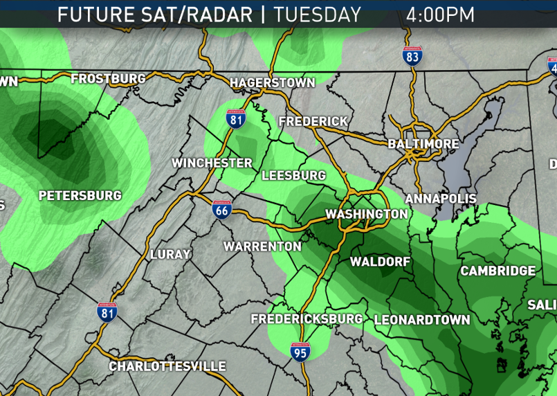
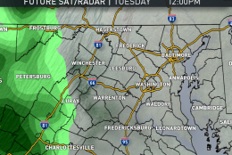
Ahead of the first warm front on Tuesday, there’s a better chance for bonafide umbrella weather.
(Data: The Weather Company. Graphics: Storm Team4)
Data: The Weather Company. Graphics: Storm Team4
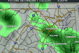
Ahead of the first warm front on Tuesday, there’s a better chance for bonafide umbrella weather.
(Data: The Weather Company. Graphics: Storm Team4)
Data: The Weather Company. Graphics: Storm Team4
Ahead of the first warm front on Tuesday, there’s a better chance for bonafide umbrella weather.
(Data: The Weather Company. Graphics: Storm Team4)
Data: The Weather Company. Graphics: Storm Team4
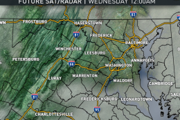
At most, rainfall amounts will total less than a third of an inch from Monday morning through Wednesday morning.
(Data: The Weather Company. Graphics: Storm Team4)
Data: The Weather Company. Graphics: Storm Team4
At most, rainfall amounts will total less than a third of an inch from Monday morning through Wednesday morning.
(Data: The Weather Company. Graphics: Storm Team4)
Data: The Weather Company. Graphics: Storm Team4
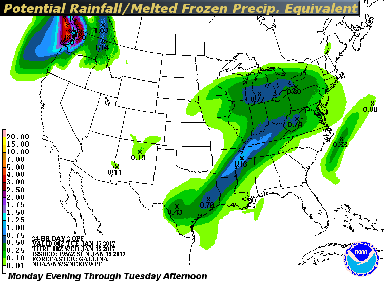
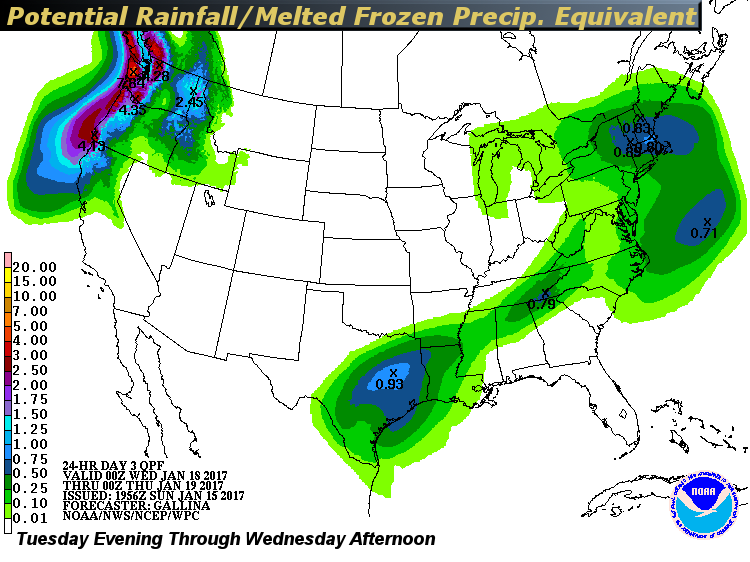
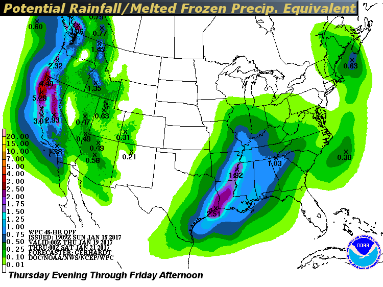
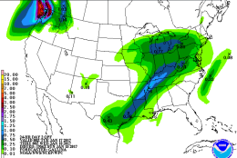
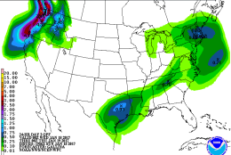
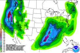
These maps show the potential rainfall amounts for the country (including the melted equivalent, i.e. what would the amount be if it were rain, not snow/ice) according to the Weather Prediction Center. Notice the heaviest amounts in the South and then the Pacific Northwest and the Rockies. Amounts here are not that excessive, but toward the end of the week there is the swath heading our way. As noted early, there are still uncertainties as to when it starts here on Friday. Amounts are in inches.
(Weather Prediction Center, NOAA)
Weather Prediction Center, NOAA
These maps show the potential rainfall amounts for the country (including the melted equivalent, i.e. what would the amount be if it were rain, not snow/ice) according to the Weather Prediction Center. Notice the heaviest amounts in the South and then the Pacific Northwest and the Rockies. Amounts here are not that excessive, but toward the end of the week there is the swath heading our way. As noted early, there are still uncertainties as to when it starts here on Friday. Amounts are in inches.
(Weather Prediction Center, NOAA)
WASHINGTON — The workweek ahead will feature a few chances for umbrella use, but in this pattern there will not be a lot of available cold air to tap to bring any wintry precipitation.
The pattern could be described as “split flow,” where there is a northern branch of the jet stream — keeping the arctic air trapped in the Arctic — and a southern branch of the jet stream keeping a supply of mild temperatures and moisture transported up from the Gulf of Mexico.
About every day and a half will be the frequency for these systems this week, and with that timing it would appear that some if not all of Inauguration Day will have some rain. These disturbances are notoriously difficult to time hour by hour, especially this far in advance, but it will likely be worth it to have some kind of rain plan for outdoor Inauguration Day activities.
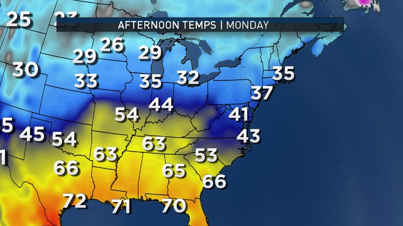
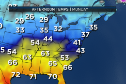
Monday, Martin Luther King Jr. Day, will start off with mostly easterly winds as high pressure moves away, the same high pressure system that kept it dry on Sunday.
The easterly flow will keep clouds around with chances for drizzle of a few sprinkles, mostly south and west of Washington. One or two batches of drizzle may become “heavy” enough to be considered a actual shower, but it doesn’t look like it will be a big deal.
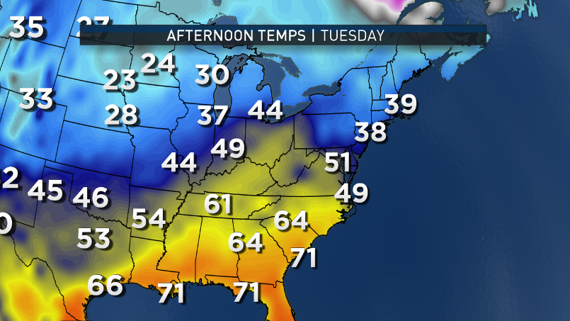
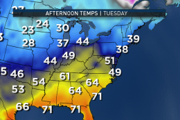
On Tuesday, the area will see the storm system, which created the big ice storm in the middle of the country over the weekend, head toward D.C. and drag a warm front with it. The center of the storm system will pass west up toward the Great Lakes, so it will stay on the warm side. But moisture from the Gulf of Mexico will override the front and start bringing a more substantial rainfall by the end of the day Tuesday, possibly in time for the evening rush.
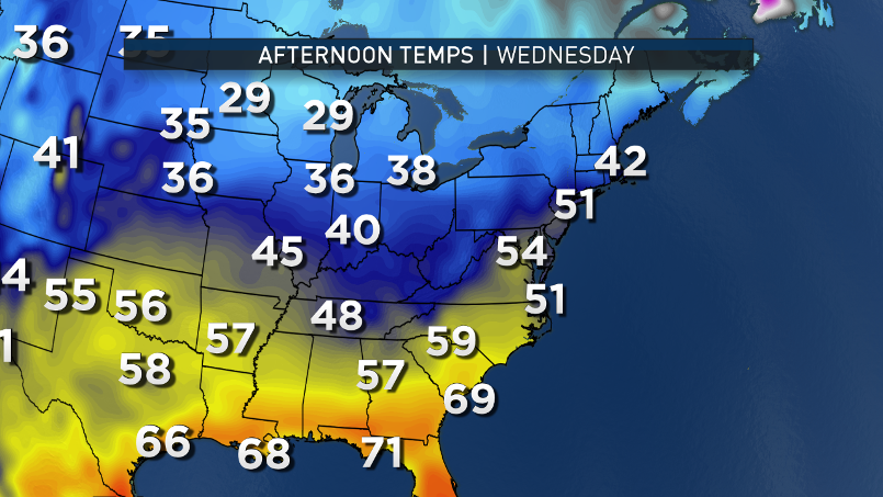
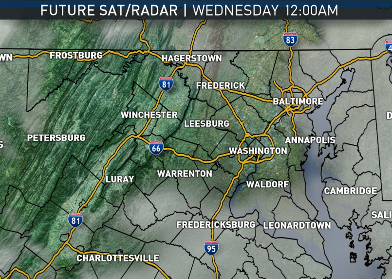
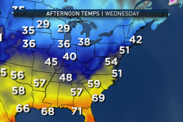
That rain will last into Tuesday night and at least Wednesday morning, ending after the rush. Then we’ll be south of the warm front and temperatures will be well below average courtesy of southwest winds. A cold front will pass through in the afternoon and evening; but that cold front will have Pacific air behind it, not arctic, so the cool-down will be modest at best.
Thursday looks dry thanks to high pressure, but then as that moves away, the southern branch of the jet stream will send another storm system this way with Gulf Moisture to create clouds and more rain, likely affecting Inauguration Day. At this point, it’s very uncertain whether that rain event will be from Thursday night to Friday morning, all day during the day, or dry to start with rain arriving by the end of the day, ending at night.
Daily weather hightlights
Monday
Overcast and damp
Not as mild as Sunday, but seasonable
Patchy drizzle or a few sprinkles, mostly south and west of Washington
Tuesday
Still overcast
Milder with more southerly winds instead of easterly
Light rain and drizzle arriving before the end of the day
Wednesday
Rain ending in the morning
Sun starts peeking through the clouds again
Breezy and unseasonably warm, but cooling and drying late in the day
Thursday
Calmest day of the week, not a lot going on
50/50 clouds and sunshine, but clouds increasing in the evening and at night
Friday/Inauguration Day
Rain arriving at some point in the day, lots of uncertainty as of this point as to when it starts, be it morning, midday or evening