The same weather system piling up heavy snow in the western U.S. is expected to push into the D.C. region and bring problems of its own.
The storm center will fade after producing a midweek blizzard in the northern Plains. But moisture on its far southern flank will initiate severe weather in the lower Mississippi Valley Tuesday and Wednesday. It will be this moisture that slides to the East Coast, while strong high pressure anchored over the Northeast supplies the cold air initially.
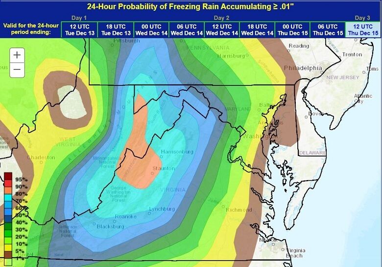
The latest data indicates freezing rain likely developing across the entire region during the Thursday morning commute, except along the shores of the Chesapeake Bay.
- Listen to WTOP online and on the radio at 103.5 FM or 107.7 FM.
- Weather forecast
- Sign up for WTOP alerts
As the day unfolds, the cold air will erode from east to west, allowing the transition to all rain in Washington within an hour or two after starting. That transition to all rain won’t occur until early Thursday afternoon around the Blue Ridge.
Sidewalks and colder metal surfaces like windshields and railings will first become icy. The faster transition to rain inside the Beltway will likely prevent roads from becoming a sheet of ice. But a prolonged freezing rain event will allow ice buildup on trees and power lines, with secondary roads likely to become icy in the western and far northern suburbs.
Another common weather hazard that develops in this particular type of storm system is dense fog in the Blue Ridge. Motorists should allow extra time for the morning and afternoon commutes on Thursday.
High winds and a rapid transition to an Arctic air mass following an ice storm is the perfect disaster for producing multiple power outages. Fortunately, light winds and warming temperatures on Friday will allow most of the ice accretion to melt in the northern and western suburbs. A more sustainable cold blast will invade the region starting this weekend.
Historically, January and February are notorious for ice storms in the D.C. suburbs.
The winter of 1993-1994 was the perfect example of multiple ice storms that produced power outages in the western suburbs. Ice storms develop in our region when strong, cold high pressure becomes anchored across the Northeast and funnels a low-level cold air mass down along the Appalachian spine while a moisture-logged storm approaches from the south.