After a wet Tuesday, the remnants of Hurricane Ida will dump even more rain on an already-water-logged area — and bring the risk of both flooding and flash flooding.
“The rain would be enough of a problem during a drought, but we have saturated ground and swollen creeks already, so there is no room for this excessive rainfall,” said Storm Team4 meteorologist Matt Ritter.
Flash flooding, he said, will be “a serious threat” for small streams and creeks — as well as roads with poor drainage — late Tuesday and through Wednesday. The threat of flooding will then shift to larger creeks and rivers Wednesday and into Thursday, well after the storm has moved on.
The National Hurricane Center’s latest forecast calls for Ida to swing east over the D.C. region as a tropical depression. However, like most decaying former hurricanes, torrential rains will be felt far and wide regardless of the path it takes.
Winds of up to 39 mph are expected with scattered power outages possible. What’s left of Ida will also bring damaging winds and the threat of tornadoes, said Storm Team4’s Amelia Draper. (A tornado watch is in effect through 3 a.m. in areas southwest of D.C., including Spotsylvania and Culpeper counties in Virginia.)
In anticipation of the severe weather, school systems have announced their plans for Wednesday. Stafford County schools in Virginia said that school buildings are closed. Staff will telework and students will be in asynchronous learning.
Culpeper County schools said that they are monitoring the situation, but as of 9 p.m. Tuesday, the plan is for a regular school day Wednesday.
Here’s how Draper sees it all playing out:
- Rain at times through 8 or 9 a.m. on Wednesday.
- Cloudy and a bit humid later Wednesday morning.
- Then storms and downpours start around noon and continue through midnight Wednesday. Flooding is possible, especially north and west of the D.C. area. Strong winds and a few tornadoes are possible, especially around D.C. and Baltimore and toward the east.
- Expect all the rain to end early Thursday.
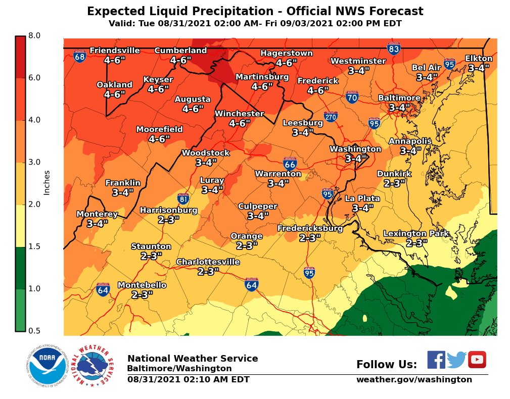
Up to 3 inches are expected in much of the already-waterlogged D.C. area; greater totals are possible north and west of D.C. and Baltimore.
A Flash Flood Watch will be in effect for the WTOP listening area from Wednesday morning through Thursday morning.
- Listen to WTOP online and on the radio at 103.5 FM or 107.7 FM.
- Current traffic conditions
- Weather forecast
- Closings and Delays
- Sign up for WTOP alerts
“If you have travel plans on Wednesday, Wednesday night or Thursday morning, consider changing them to avoid being out in the worst of the storm,” Storm Team4’s Chuck Bell said.
“Make sure all gutters and storm drains are clear. If you have a basement with a sump pump, make sure it is in good working order. If you have ground-level doors that are susceptible to rising water, place sandbags around them to prevent floodwaters from entering.”
On Tuesday afternoon, Virginia Gov. Ralph Northam declared a state of emergency for the commonwealth, and warned Virginians to stay alert — especially along the Interstate 81 and Interstate 66 corridors.
“While we’re fortunate in Virginia to have avoided the hurricane itself, heavy rainfall is expected to cause additional flash flooding and dangerous conditions in portions of the Commonwealth,” Northam said in a statement.
In D.C., Mayor Muriel Bowser said the District’s Emergency Operations Center will be activated. “We are asking residents to take Ida seriously and to pay close attention to the weather conditions and latest alerts,” she said in a statement Tuesday.
And Maryland Governor Larry Hogan urged residents “to be prepared, heed warnings from local authorities, and use common sense.”
Flood-prone Alexandria, Virginia, handed out free sandbags to residents Tuesday morning, in preparation for the heavy rains.
“Most folks will use sandbags around doors that lead to basements or window wells to prevent water from getting into homes,” said Yon Lambert, director of Alexandria’s Department of Transportation and Environmental Services.
“Where we’re having tidal flooding and the river will rise, businesses along Union Street and in the lower King Street corridor will place them outside the entryways to make sure water isn’t intruding.”
‘Turn around, don’t drown’ and other safety tips
A few tips from Maryland and D.C. officials on staying safe during the storms …
- Stay off the roads so emergency workers can help others.
- Stay out of floodwater. It can contain contaminants like sewage or even be electrically charged. On the road, it only takes 6 inches of water to make a driver lose control of their car (“Turn around, don’t drown”).
- Know where floodwaters have receded. It’s possible that flooding weakened a road, and it could collapse under the weight of a car.
- Never turn off power or operate circuit breakers while standing in water.
- Keep your phone and other devices charged.
- Sign up for AlertDC at alertdc.dc.gov
Forecast:
Tuesday night: Rain at times and a chance of storms. Cloudy and humid, with lows in the mid 60s to low 70s.
Wednesday: Rain grows more likely throughout the day. Heavy at times with some strong to severe storms possible, mainly later in the day. Cloudy, a bit humid and later breezy. Highs in the 70s and low 80s.
Thursday: Rain ends very early in the morning. Clouds giving way to sun, low humidity, breezy and nice, with highs in the mid 70s to 80.
Friday: Sunny and spectacular, with highs in the mid to upper 70s.
Current conditions:
WTOP’s Abigail Constantino, Nick Iannelli and Jose Umana contributed to this report.