WASHINGTON — The new workweek will start off in the middle of the region’s latest heat wave — defined in our part of the country as at least three consecutive days with 90 degrees or above.
After getting a small respite on Sunday, the humidity will have crept back up to muggy levels already by the start of the day.
Canadian high pressure is heading our way for midweek, and a cold front will be part of the transition on Monday and Tuesday while it approaches. Lots of heat and humidity ahead of the front will mean scattered showers and some thunderstorms will be likely on Monday and Tuesday. But there are still some uncertainties on the speed of the front. That’s important because the closer one is to the leading edge of the front, the stronger the storms could be.
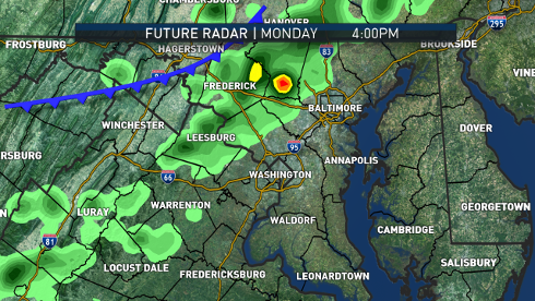
As of this posting, the threat appears to be mainly north of D.C. for the strongest storms on Monday — though everyone has some potential for storms, regardless of strength.
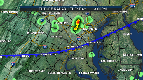
On Tuesday, the focus for the stronger storms appear to be south of D.C. — though, again, everyone has potential for some storms. In either scenario, on Tuesday night, folks will notice the humidity dropping and that will continue into Wednesday, when the high is directly on top of us.
The graphics above show the potential for scattered showers and thunderstorms. The greatest threat will be Monday, ahead of the cold front. Tuesday’s threat is not as great as the leading edge of the cold front will be moving through central Virginia and southern Maryland.
Hands down the best night of the week for an evening at Nats’ Park will be Wednesday.
However, this is mid-July, so just know that the comfortable stuff won’t stick around. As the high slides to our south and east, it will become the newest “Bermuda high,” pumping the heat back in starting on Thursday.
It looks like there will be several days in a row of above 90 degree temperatures, so that would be another heat wave. At least at first, the Gulf of Mexico won’t be tapped for moisture, so this heat wave won’t start out with too much humidity, and there won’t be much of a chance for thunderstorms Thursday or Friday. The worst of the heat and humid conditions during that time will be in the middle of the country. But those very hot and humid conditions will likely slide east over the weekend with an increasing chance for thunderstorms.
Other than those few scattered chances for storms on Monday and Tuesday, it looks like a mostly dry and quiet week. Hazy, lazy days of summer indeed.
Daily weather highlights
MONDAY
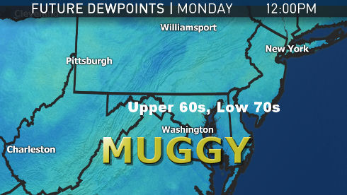
• Dewpoints climb back into the upper 60s and low 70s, making it feel muggy again.
• High temperatures easily into mid to upper 90s.
• Hit-and-miss thunderstorms, some with heavy rainfall.
TUESDAY
• More clouds; likely not as hot as Monday.
• More hit-and-miss thunderstorms, some with heavy rainfall, but most likely areas shift to south of D.C.
• Northern Maryland will be relatively cooler and less humid first, then it gets more comfortable everywhere else at night.
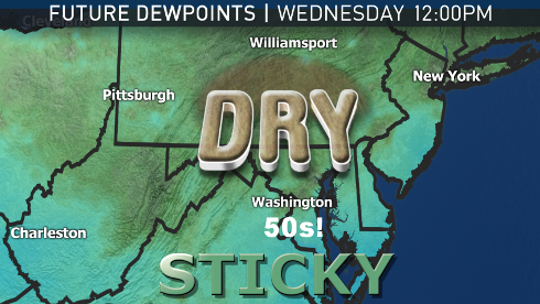
WEDNESDAY
• More seasonable temperatures; not as hot.
• Dewpoints in the 50s to near 60 means comfortably warm conditions.
• Great day for outdoor summer activities.
THURSDAY
• Heat returns back into the 90s.
• Humidity lags behind the heat a bit.
FRIDAY
• Very hot temperatures in the mid to upper 90s.
• Humidity starts climbing back up as dew points get back into the mid to upper 60s.
The following graphics show the potential for scattered showers and thunderstorms. The greatest threat will be Monday ahead of the cold front. Tuesday’s threat is not as great as the leading edge of the cold front will be moving through central Virginia and southern Maryland.
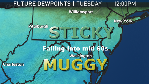
The next three images show the changes for dewpoints on the way. Remember: the higher the dewpoint temperature, the greater the amount of moisture in the air. So when the dewpoint drops, it gets more comfortable, generally speaking.
The process is a bit subjective, but on Monday, the entire region will be muggy. On Tuesday, behind the cold front, the humidity starts dropping from north to south. By Wednesday, all of us are feeling fine. Actual temperatures will be more seasonable, in the upper 80s.
The WTOP Workweek Weather Blog is intended as an in-depth yet plain-language summary of the business week’s weather potential in the D.C. area, along with an explanation of the contingencies and uncertainties that exist at the time of publication. For the latest Storm Team 4 Forecast, check out the main WTOP Weather Page.
Note: The WTOP Workweek Weather Blog is intended as an in-depth yet plain language summary of the business week’s weather potential in the D.C. area along with an explanation of the contingencies and uncertainties that exist at the time of publication. For the latest actual Storm Team 4 Forecast, check out the main WTOP Weather Page.