By Matt Ritter, Storm Team 4 meteorologist
WASHINGTON — Danny became the first hurricane of the 2015 Atlantic tropical season Thursday.
The storm is currently still moving west, heading for the Caribbean islands. And as of the 2 p.m., the storm has strengthened to a Category 3 storm.
The hurricane’s maximum sustained winds Friday had increased to near 115 mph (185 kph). The U.S. National Hurricane Center says the hurricane is not expected to intensify, and a weakening trend is forecast to begin later Friday.
Earlier Friday, the storm had winds of 105 mph and it was moving to the west-northwest at 10 mph.
Compare the wind field of Danny to a snapshot of Katrina as it was getting ready for the Louisiana landfall. The images aren’t exactly to scale but one can still see the difference in severity:
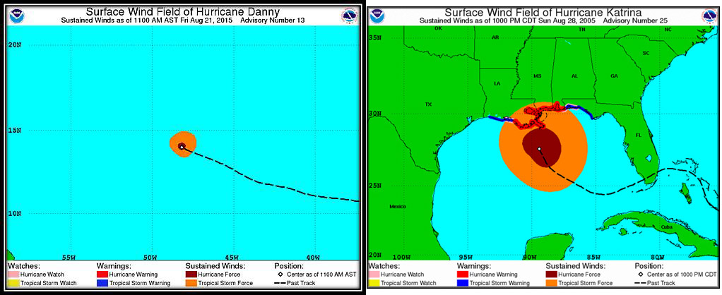
For another comparison, Danny’s wind field would just about fit within the Capitol Beltway.
Tiny Hurricane Danny’s hurricane force wind field would fit inside the Beltway. #DCWX #DCTraffic pic.twitter.com/AaLHWIL6qB
— Dave Dildine (@DildineWTOP) August 21, 2015
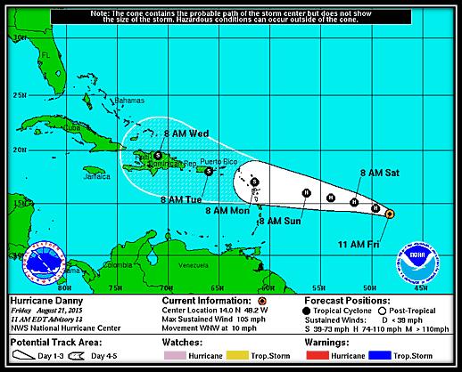
Danny is expected to weaken and become a tropical storm sometime Sunday and stay at that strength through the middle of next week when it would become a heavy rain threat for Puerto Rico and Hispaniola if the center follows the forecast track as shown in this graphic:
The first named storm this season, Tropical Storm Ana, formed on May 7 and lasted until May 10 (ahead of the official start of the Atlantic Hurricane Season, which lasts from June 1 to Nov. 30) and affected the Carolinas, Hampton Roads and the Delmarva peninsula. Tropical Storm Bill lasted from June 15 until June 17, affecting parts of Texas. Tropical Storm Claudette lasted from July 13 and only until July 14 and stayed out to sea in the western Atlantic.
The season has definitely not been busy, nor has it had any major storms (A major hurricane is considered a category 3 or higher on the Saffir-Simpson Hurricane Wind Scale. )
To become large and powerful hurricanes, storms need an ample supply of very warm waters as fuel, extended periods of time over those waters and an organized upper level high pressure system for the “exhaust system.”
You can think of tropical storms and hurricanes as engines and when natural factors interfere with that engine’s operation, the storms don’t do well. Ana and Bill had little time over water. Claudette encountered a strong northern jet stream, which sheared it apart. And Danny, defying some odds initially, is expected to encounter more wind shear from the southern branch of the jet stream, which is being enhanced by this year’s strong El Nino.
(Click here to read about the impacts of El Niño and La Niña on the hurricane season)
Another factor this season and the past few years has been persistent dust coming off the Sahara Desert, which can prevent clusters of thunderstorms forming in the first place – thunderstorms that would then move over the warm waters of the tropical Atlantic Ocean and organize into tropical low pressure systems.
Even though it’s taken this long to get a named hurricane, it did happen while we are approaching peak of the season.
Also, Danny formed in an area climatologically favored for storm formation this time of year.
Unless there is a remarkable turn of events, Danny is not expected to strengthen or affect the East Coast of the United States. Forecasting tropical systems is definitely not as difficult as it used to be, however they can sometimes generate surprises, not usually about the track, but the intensity, as every little detail in the atmosphere matters.
No new storms in the Atlantic appear likely soon, but the next name to be checked off the list would be Erika. The rest of the names for this year are Erika, Fred, Grace, Henri, Ida, Joaquin, Kate, Larry, Mindy, Nicholas, Odette, Peter, Rose, Sam, Teresa, Victor and Wanda.
And in case you are wondering what happens if all the names get used up, Greek letters are used. It has happened before: In the punishing year of 2005 when Hurricanes Katrina and Rita hit, the list went all the way to Tropical Storm Zeta, which formed on Dec. 30 (after the official end of the season). Zeta stayed over the open waters of the Atlantic however.