UPDATE: April 20, 2015, 10:05 p.m.
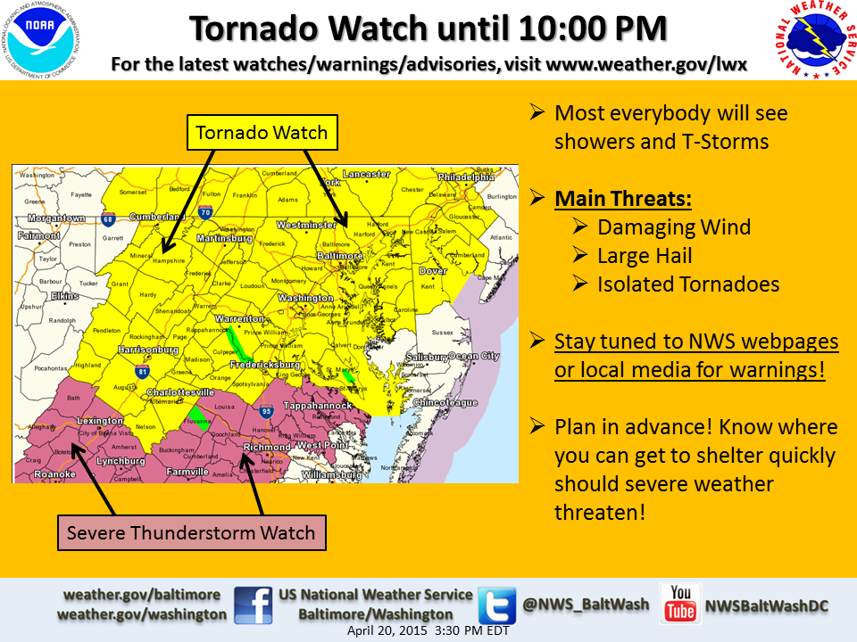
At 10 p.m. Monday, a Tornado Watch was cancelled for the region. It had previously been in effect until midnight, but only isolated severe storms are anticipated. The main threat currently is damaging wind and large hail.
A Severe Thunderstorm Warning is in effect until 10:15 p.m. for northeastern Charles, south central Anne Arundel, Prince George’s, northwestern Calvert and northern St. Mary’s counties.
A Flash Flood Warning has been issued until 12:15 a.m. Tuesday for central Spotsylvania County, south central Stafford County, and the City of Fredericksburg in Virginia.
The area will see scattered storms until until around 11 p.m. or midnight. Some may produce lightning, hail and brief heavy rain.
EARLIER: April 20, 2015 4:30 p.m.
WASHINGTON — A Tornado Watch has been issued for the D.C. area until 10 p.m.
EARLIER: April 20, 2015 8:30 a.m.
WASHINGTON — We had a good dose of rain overnight, with Ronald Reagan Washington National Airport picking up about 0.83 inches of rain. While the rain continues to taper off and push to the northeast through the morning, more rain is in the forecast for this afternoon, so keep those umbrellas handy!
Wet roads from the overnight rain will eventually dry as we continue into Monday morning. A warm front over central Virginia will lift to the north through the first half of the day, putting the WTOP listening area in the warm sector. Temperatures will shoot up to around 80 degrees for daytime highs.
In this case, receiving some sunshine Monday afternoon isn’t so good. It will only aid in the destabilization of the atmosphere, making it juicier while creating a better chance for some strong to severe storms this afternoon and evening. The storms will all trigger from a trough aloft and a cold front that will sweep through from the west to the east later this evening.
TIMING
Expect storms to enter the western suburbs, along the Interstate 81 corridor, around 2 p.m. Storms will continue to move east through the late afternoon and into Monday evening.
All rain should be moving out between 9 p.m. and 10 p.m., but we will continue to watch the radar through the evening. Unfortunately, it does look like rain and/or storms could be in the D.C. region for commuting times, so make sure to plan ahead.
SEVERITY
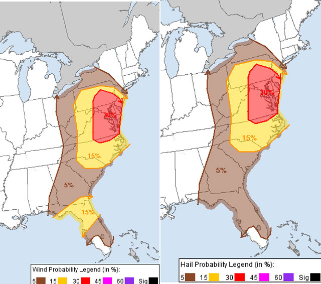
With some breaks forecast in the sky conditions Monday, it will really warm up. If we see more clouds, temperatures won’t get quite as high and the atmosphere will be a little bit more stable. But if there’s sunshine, expect some of these storms to really pack a punch as they move through the region. The Storm Prediction Center has outlined the area in a slight risk area for severe weather. We have the best chance for some damaging winds, heavy rainfall and even some hail.
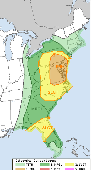
The WTOP listening area is in a “Slight” to “Enhanced” risk for severe weather. Listeners in the “Slight Risk” (yellow) area in the map above can expect isolated intense storms. Folks in the “Enhanced Risk” (orange) region, including D.C., can expect numerous severe storms. These will be widespread and intense. In the entire area, we have a chance of strong winds with wind damage, hail over 1 inch and heavy downpours. All of our area is on the low end for any tornadic activity, but we will continue to watch as these storms develop.
Again, storms will be out of here after 10 p.m. as they move off to the east. Skies will go partly cloudy Monday night, with temperatures falling into the mid-50s. Monday will be the warmest day of the week, as it looks like temperatures will be well below normal by Friday. The next chance of rain will be on Wednesday afternoon, as another cold front moves through the region.