UPDATED at 5:10 p.m. 2/14/2015: (WTOP/Dave Dildine)
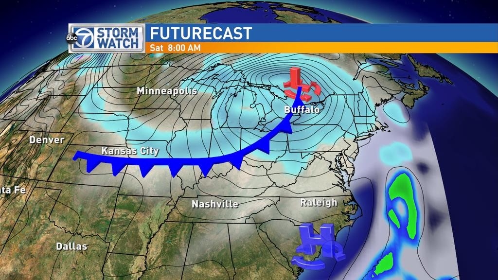
WASHINGTON — An intense snow squall is crossing the Ohio Valley and setting its sights on the Washington Metro Area. The National Weather Service is urging the public to prepare for rapidly deteriorating weather conditions this evening.
A winter weather advisory is in effect for the entire region through midnight. The most intense weather is expected through 8 p.m. as a narrow band of heavy snow overtakes the area.
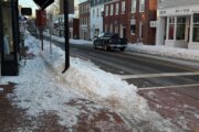
The onset of precipitation is expected to be sudden. Although temperatures approached 40 degrees in many spots on Saturday, the cold front will cause temperatures to plummet during the period of heavy snow. This is likely to result in hazardous road surface conditions.
In Ohio, the snow squall caused numerous multi-vehicle piles-ups along Interstate 70.
Thunder and lightning has been observed west of the area in the heaviest portions of the snow squall. Thundersnow is possible as the line of snow pushes overhead.
Travel conditions in snow squalls deteriorate quickly and can cause significant disruptions despite low snowfall totals.
Strong, damaging winds are likely to continue after the snow ends throughout the evening and overnight hours. A high wind warning is in effect for damaging wind gusts that could exceed 60 mph. Power outages are likely late Saturday night and Sunday.
Drivers should prepare for hazardous driving conditions during the heavy snow burst Saturday evening. High profile vehicles will be difficult to steer in the high winds overnight, especially on bridges and straightaways through clearings. Drivers should treat all dark, powerless intersections as all-way stops.
All unnecessary travel should be postponed until conditions improve by late evening.
Snow sticking and blowing all over, covering road signs in Silver Spring. @Wtop pic.twitter.com/HhaP5ugShr
— Megan Cloherty (@ClohertyWTOP) February 15, 2015
@WTOPtraffic I270 heading to Rockville. pic.twitter.com/p5vCvUkfvL — Cindy S Mendez (@CJSMendez) February 15, 2015
Car spins off the road on I 70 in West friendship. #wtop pic.twitter.com/Y2ktRzvMi0 — Ari Ashe™ (@ariashe) February 15, 2015
————————
Previous Information: (By Lauryn Ricketts)
WASHINGTON — It is going to get dangerously cold around the region this weekend. Not only are we going to have some of the coldest temperatures we have seen in over a year across the region, but the bone chilling winds are going to be the main culprit in this big chill. So grab a loved one this Valentine’s Day weekend and hunker down inside, because it is going to be brutally cold outside.
Friday was almost a practice day, because by the time we get to Sunday, it will feel a lot colder. Clear skies will continue into the evening with just a few clouds building overnight. Temperatures Friday night fell into the teens.
Saturday, winds shifted out of the south as high pressure scooted off the coast. That pushed our temperature to around 40 degrees! There was some sunshine to start, but that was short-lived as another arctic cold front approaches the area, increasing the cloud cover across the region.
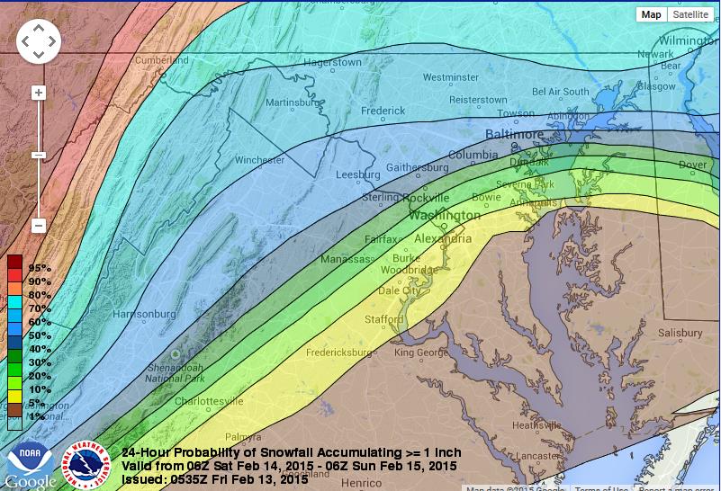
Expect some snow showers to move into the area through the afternoon and into the evening on Saturday. There could be some minor accumulation in spots, especially if we get a heavy band that sets up. We are thinking a coating to around one inch of snow accumulation possible around the area. However, if we get a heavy band that sets up, that could be a little more, and any of the heavier accumulation looks to be north and west of D.C. Note: When I mention “north and west” of D.C., generally I am speaking of western Loudoun County, northwestern Montgomery County and continuing north and west of those areas.
A snow squall is expected to spread over the region between 5 p.m. and 7 p.m. Sunday. A heavy burst of snow may be brief-lived, but driving will likely become difficult where the heaviest bands of snow develop. The National Weather Service says squalls can produce lightning and thunder, which may contribute to driver confusion as road conditions deteriorate. High winds expected to move in later Saturday evening could lead to power outages.
So if you are headed out for any Valentine’s Day festivities, you might want to keep an eye on our radar and the roads, because there absolutely could be slick spots out there with some minor snow accumulation.
Winds will increase through the afternoon turning from the south to the northwest as the front plows through the region. By Saturday night, winds will be gusting up to 50 or 60 mph in spots!
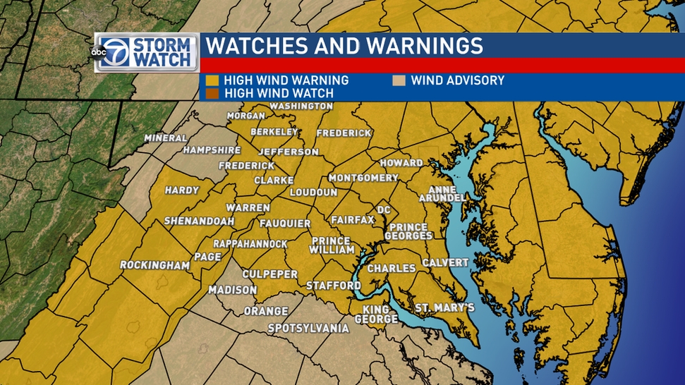
With winds of this speed, we will certainly have to watch for the impact they may cause. This could mean downed trees and possibly power lines, leading to outages. Also, it may make it tough to drive, especially for high profile vehicles.
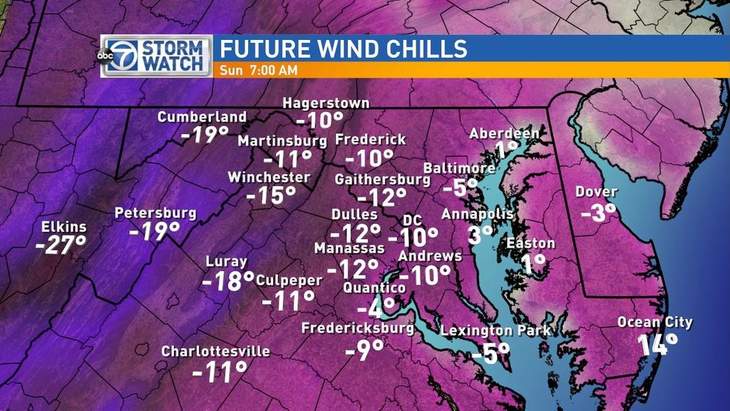
Temperatures will fall into the single digits and teens for overnight lows Saturday into Sunday. That means wind chills will be well below zero for much of the region.
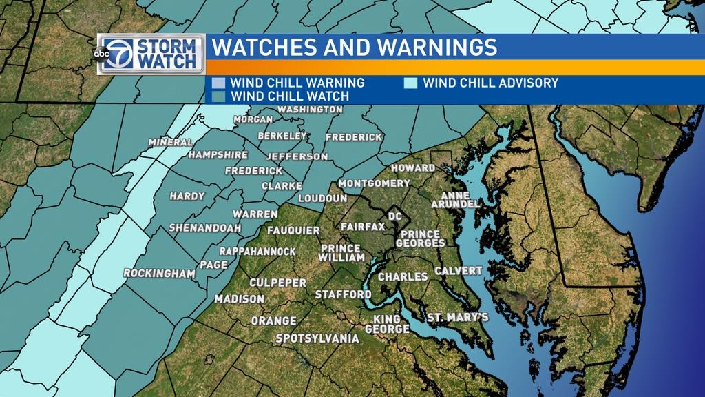
Wind chill readings in these watch areas could be 20 to 30 degrees BELOW zero (especially higher elevations). These absolutely will lead to hypothermia and frostbite if you are outside for a prolonged period of time without proper attire. Wind chills not in the watch area are still forecast to be below zero for much, if not all, of Sunday.
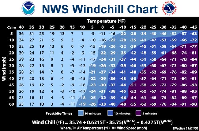
For those who want to know how we calculate wind chills and frostbite times, click here for more information. Below is a chart you can also use to figure it out on your own.
Sunshine will stay for Sunday, but those winds aren’t going anywhere. Temperatures will only top out near 20 degrees in D.C. with most of the region staying in the teens. We could challenge some records on Sunday, as well, for air temperatures. The lowest daytime high on record in D.C. and BWI is 18 degrees, both set in 1943. The lowest daytime high at Dulles is 22 degrees, set in 1979.
Winds will finally calm early Monday morning. President’s Day is looking a lot better in terms of winds (they will be in the 5 to 10 mph range) but it will still be chilly. Temperatures will stick in 20s with some sunshine to start and more clouds filling in later. So enjoy this weekend, but try not to spend too much time outside – which should give you an excuse to stay indoors with your Valentine.
WTOP’s Dave Dildine contributed to this report.