A few morning showers are possible Monday, but the main focus is the threat for severe thunderstorms later in the afternoon and early evening.
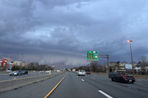
WTOP meteorologist Mike Stinneford said the Storm Prediction Center places the D.C. region under a Moderate Risk, level 4 of 5, which is rare.
“It basically tells us that the models had a pretty good idea that we were going to see an outbreak of severe weather on Monday afternoon,” Stinneford said.
He said several rounds of storms are possible, beginning with “discrete supercells” in the early afternoon, especially across the western suburbs. Those could form between noon and 2 p.m., ahead of a stronger squall line.
“I do believe this is going to affect the metro area right around the first part of the rush hour on Monday afternoon,” Stinneford said. “This squall line may produce damaging winds, large hail and even some tornadoes.”
Stinneford said the main squall line is expected to move into the metro area between 2 and 5 p.m., likely impacting the first part of the ride home.
“Especially the first part of the rush hour, we may see some really negative impacts, some high winds, some hail, the risk of tornadoes and also some very heavy rainfall may cause some flooding on area roadways,” he said.
The severe threat ends Monday night, but lingering showers may briefly mix with wet snow as temperatures fall into the 30s.
Stinneford said sunshine returns Tuesday, but conditions will be windy and cold into Wednesday.
A warmup into the mid 50s is expected by Thursday.
- Listen to WTOP online and on the radio at 103.5 FM or 107.7 FM.
- Current traffic conditions
- Weather forecast
- Closings and Delays: DC-area schools make decisions for Monday instruction
- Sign up for WTOP email alerts
- Get custom alerts with the WTOP app for Apple and Android phones
FORECAST
SUNDAY: Mix of clouds and sunshine. Becoming breezy. Highs in the upper 50s and lower 60s.
SUNDAY NIGHT: Showers, chance of thunderstorms. Lows in the low to mid 50s.
MONDAY: Chance of morning showers. Afternoon thunderstorms likely. Storms may produce damaging winds, large hail and tornadoes. Highs in the upper 60s to lower 70s.
TUESDAY: Partly to mostly sunny, windy and cold. Highs in the upper 30s to lower 40s.
WEDNESDAY: Partly cloudy. Highs in the upper 30s to lower 40s.
THURSDAY: Partly sunny. Highs in the mid 50s.
CURRENT CONDITIONS
Get breaking news and daily headlines delivered to your email inbox by signing up here.
© 2026 WTOP. All Rights Reserved. This website is not intended for users located within the European Economic Area.