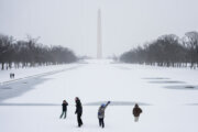
Temperatures will take a steady nosedive Saturday morning as major wind gusts hit the D.C. region, making it feel much colder.
But it’s not just the bitter cold that residents need to worry about.
“Damaging winds could blow down some trees and power lines, so power outages will be possible,” said 7News First Alert Meteorologist Jordan Evans.
Wind gusts of 45 to 60 mph, according to WTOP meteorologist Mike Stinneford.
“Wind chills will be as cold as 15 below zero,” Stinneford said. Be careful out there because weather this cold means you could get frostbite on exposed skin in as little as 30 minutes, he said.
An extreme cold warning and a high wind warning went into effect at 4 a.m. Saturday.
Stinneford said wind gusts of up to 64 mph were recorded on the Chesapeake Bay Bridge. Full wind restrictions are in effect on the bridge.
The high winds will be an issue all day Saturday throughout the region until around sunset, with temperatures in the teens to lower 20s in the afternoon. The wind will remain steady and strong overnight with wind chills continuing around zero.
The frigid temperatures are expected to stick around a bit longer. The extreme cold warning expires Sunday morning at 10 a.m.
Cold conditions will persist into early Sunday, with temperatures remaining below freezing and wind chills staying below zero.
“By Sunday, we’ll see breezy conditions, but still cold,” said 7News First Alert Meteorologist Steve Rudin. “Monday and Tuesday of next week, we start a modest warming trend.”
In a release from D.C. Mayor Muriel Bowser, she encouraged residents to remain vigilant while commuting and utilize the city’s Shelter Hotline if they have neighbors experiencing homelessness.
Her office also recommended applying a salt or sand mix when shoveling. Adding ice melt can help prevent refreezing.
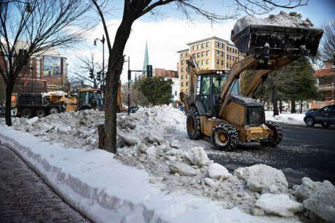
Now that the city is reinforcing its shoveling enforcement, officials are also reminding residents and businesses to clear snow from their sidewalks within the first eight hours of daylight or face a fine up to $150.
People experiencing homelessness in D.C. have access to hypothermia shelters during extremely cold weather. A list of those shelters is available online.
For those still dealing with issues from delayed trash removal and pickup, the D.C. Department of Public Works will continue tracking missed trash routes over the weekend in residential areas and alleys.
- Listen to WTOP online and on the radio at 103.5 FM or 107.7 FM.
- Current traffic conditions
- Weather forecast
- Closings and Delays
- Sign up for WTOP email alerts
- Get custom alerts with the WTOP app for Apple and Android phones
Outages
The arctic blast and high winds have knocked down the power in some parts of our area.
BG&E reports more than 2,000 power outages in Howard County.
PEPCO is reporting over 600 homes and businesses without power in Prince George’s County.
Dominion Energy says close to 500 homes and businesses are without power in King George.
How to avoid frostbite
With the windy, cold weather set to take over the D.C. region this weekend, one area doctor is asking the public to be mindful of how much time they spend outside to avoid frostbite.
Dr. Taryn Travis, with MedStar Health and Children’s National Hospital, told WTOP the cold-weather injury doesn’t start out painful. However, once numbness and tingling appear, that is a sign from the body to head inside immediately.
“Frostbite has a couple different ways that it causes damage, but basically, just the cold exposure itself causes frostbite,” Travis said.
Frostbite most often affects the hands and feet, as well as other parts of the body exposed to the elements.
Once you are in a cold environment, the body will divert blood flow away from the fingers and toes to protect the core. Travis said most frostbite injuries occur on the hands, feet, fingers, toes, noses, ears and other parts of the body not connected to the torso.
“It can happen very quickly, and it can happen with small areas of your body not covered and protected from that cold temperature and that additive wind,” she said. “Most importantly, people should keep in mind that when you start to feel numbness and tingling, that’s your body trying to tell you, ‘Hey, I need to get warm, or things are going to go south here.”
The windy conditions increase the risk of frostbite. According to Travis, a person can start to feel the effects within 30 minutes of exposure if not protected from the cold. Even rubbing your hands together to create warmth will not help, she said.
“People who wait on these things and try home remedies or see if it’ll get better on its own are people who end up at risk for amputation,” she said. “So, we don’t want people, other than getting warm again, to try to do anything to treat themselves at home.”
FORECAST
THIS EVENING: COLD ALERT
Windy and cold
Temperatures: 10-15; Wind Chill: -10 to 0
Winds: 25-35 mph; Gusts: 45-55 mph
Winds will come down very slowly, but will still gust up to about 50 mph. Wind chills will remain at or below zero.
TONIGHT: COLD ALERT
Clear, breezy
Lows: 5-10
Wind Chill: -15 to 0
Winds: Northwest 15-25 mph
Gusts: 30-35 mph
Winds remain breezy overnight which will keep wind chills as low as 15 degrees below zero for areas around the D.C. metro.
TOMORROW: COLD ALERT
Mostly cloudy, breezy
Highs: 22-26; Wind Chill: 10s
Winds: Northwest 5-15 mph; Gusts: 25-30 mph
Bitterly cold weather is expected, especially in the morning with sub-zero wind chills likely. Cold weather alerts remain in effect through the morning hours. Morning breezes will ease during the day with highs in the 20s.
TOMORROW NIGHT:
Mostly clear
Lows: 5-15; Wind Chill: 0-10
Winds: Northwest 5-10 mph
A quiet but very cold night with temperatures in the single digits and wind chills near zero degrees.
MONDAY:
Partly cloudy
Highs: 29-33
Winds: West 5 mph
Passing clouds and light winds as temperatures try to rebound behind the Arctic blast, but high temperatures will only get to freezing for the afternoon.
TUESDAY:
Mostly sunny
Highs: 40-45
Winds: North 5 mph
Sunshine continues to melt ice and snow and temperatures well above freezing will also help accelerate melting. High temperatures should get close to normal in the middle 40s.
WEDNESDAY:
Mostly cloudy
Highs: 40-45
Winds: Northwest 5-10 mph
A cloudy but seasonable day with highs in the mid 40s should continue to melt most of the snow and ice.
CURRENT CONDITIONS
WTOP’s Jessica Kronzer, Ciara Wells and Jose Umana contributed to this report.
Get breaking news and daily headlines delivered to your email inbox by signing up here.
© 2026 WTOP. All Rights Reserved. This website is not intended for users located within the European Economic Area.