▶ Watch Video: Tracking the tropics as Humberto strengthens into a hurricane
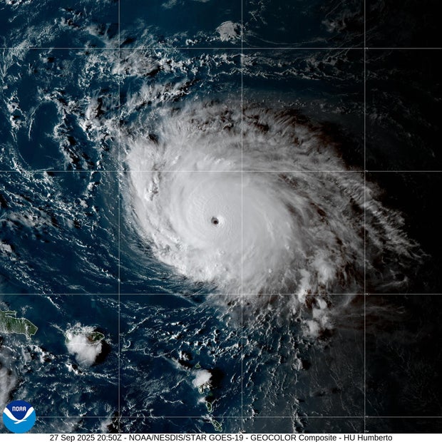
Humberto has rapidly strengthened into a Category 5 hurricane, and parts of the northern Leeward Islands, the Virgin Islands, Puerto Rico and Bermuda could see its impact as early as Saturday night.
There were no immediate watches or warnings issued for the U.S. by the National Hurricane Center but those in the Bermuda are urged to monitor Humberto’s progress.
The storm is one of two systems swirling over the western Atlantic that could potentially bring some downstream impacts to parts of the Southeast U.S. coast, from Florida to North Carolina, the director of the Miami-based hurricane center, Michael Brennan, said.
Hurricane Humberto forecast and path
As of Saturday afternoon, Humberto was located about 350 miles north-northeast of the northern Leeward Islands. It has increased its speed and was moving west at about 10 mph with maximum sustained winds of 160 mph, according to the NHC.
The storm is likely to remain a major hurricane for the next several days, forecasters said. A storm is deemed a “major” hurricane if it’s a Category 3, 4 or 5 due to the potential for “significant loss of life and damage,” the center says.
“Some additional strengthening is possible tonight,” the hurricane center said Saturday afternoon, and “fluctuations in maximum wind speeds are expected.”
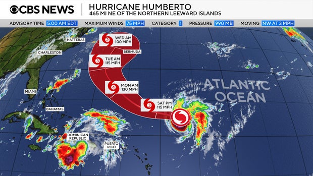
Tropical-storm-force winds extend outward up to 125 miles from the center of Humberto, and hurricane-force winds extend outward up to 25 miles, the hurricane center said.
Those along the U.S. East Coast could begin to see the effects of Humberto beginning Monday. Swells generated by the storm are likely to cause life-threatening surf and rip currents.
It is the eighth named storm of the 2025 Atlantic hurricane season. It comes on the heels of Hurricane Gabrielle, which is not impacting land as it heads farther out into the Atlantic.
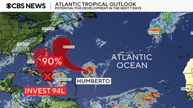
Another storm system brews over the Caribbean
The hurricane center is also closely monitoring a second storm system over the northeast Caribbean in the Atlantic, near Humberto.
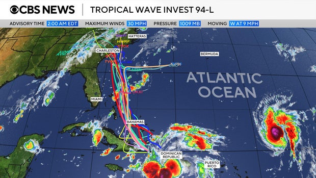
Tropical Depression Nine is likely to become a named tropical storm later Saturday night or early Sunday, NHC said in its 5 p.m. ET update.
The system is expected to bring “significant rainfall” to portions of Cuba and the Bahamas. They could see up to 8 inches of rain, the hurricane center said. It will also likely produce flash and urban flooding, with the possibility of mudslides in higher terrain across eastern Cuba.
The system is expected “to move across the central and northwestern Bahamas this weekend and approach the southeast U.S. coast early next week,” the hurricane center said Saturday.
There is also a possibility it could interact with Humberto — a phenomenon known as the Fujiwhara effect, in which two different storms converge and either join or spin around each other. But CBS News meteorologist Nikki Nolan said such an outcome is not considered likely in this case.