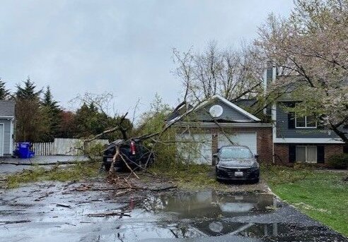
Heavy rain flooded parts of the D.C. area with thunderstorms bringing hail and damaging winds along with a cold front’s arrival Wednesday afternoon. Here’s what you need to know.
- Listen to WTOP online and on the radio at 103.5 FM or 107.7 FM.
- Current traffic conditions
- Weather forecast
- Closings and Delays
- Sign up for WTOP alerts
There was a possibility for an isolated tornado as the cold front moved through, according to the National Weather Service, which said just before 4:30 p.m. Wednesday most of the severe weather was east of the D.C. metro area.
Scattered showers will stick around the D.C. region Wednesday evening, the NWS said.
Parts of southern Maryland, including Calvert and St. Mary’s counties, were under a tornado watch until 7 p.m., according to the Maryland Department of Emergency Management. WTOP Meteorologist Mike Stinneford said the heaviest weather was across Southern Maryland and moved out of the area by early evening.
“We’re going with a ‘severe alert’ because along this line, it has had a history of producing some severe weather,” said 7News First Alert Chief Meteorologist Veronica Johnson.
Beyond the D.C. area, parts of central and southeastern Virginia were also under a tornado watch. King George County was among the areas impacted by the watch, as well as the cities of Richmond, Lynchburg and Virginia Beach.
2:03pm-A line of strong thunderstorms continues to push north from the northern neck of VA into southern MD over the next 1-2 hrs. Damaging winds, & hail will accompany this line along w/ the possibility of a tornado. Flooding will also be a concern for the metros points east. pic.twitter.com/ijZ7yd8uMq
— NWS Baltimore-Washington (@NWS_BaltWash) April 3, 2024
Johnson said these storms brought tornadoes and large hail to the Ohio and Tennessee Valley area Tuesday. For the D.C. area, the risk for some smaller hail and damaging winds in excess of 55 to 60 mph remained Wednesday.
The ground was still saturated after a wet Tuesday across the D.C. region, meaning the rain coming in from Ohio and West Virginia created an elevated risk for flash flooding.

Some areas were under a flood warning from the National Weather Service until Wednesday afternoon, including parts of Northern Virginia and central Maryland.
Most of the D.C. region was under a flood watch until late Wednesday afternoon, as up to 3 inches was possible in some areas.
High waters were expected to approach the curb near the area of King Street and Strand Street in Alexandria. Some portions of the Tidal Basin were expected to flood near Ohio Drive and the Hains Point Loop Road.
Between 1-1.5 inches of rain had fallen in areas under the flood warning and another half inch of rainfall was possible, NWS said at around noon.
High temperatures were in the mid 60s Wednesday before temps were expected to cool down Thursday to highs in the mid-50s. The potential for spotty thunderstorms with possible hail remains Thursday.
There’s another coastal flood advisory in effect Thursday afternoon through Friday morning. Flooding is likely, especially around the time of high tide, NWS said.
A passing shower could blow through Friday; it will be windy and cool with highs in the lower 50s, according to Johnson. The forecast finally dries out Saturday.
There are still some road closures as a result of flooding. Check with WTOP Traffic for the latest on the road conditions.
Beach Drive is closed between Pinehurst Parkway and West Beach Drive, and Route 450 is closed near Huntwood Drive in Anne Arundel County, Maryland.
Full forecast
WEDNESDAY EVENING: Chance of a shower or thunderstorm, mainly along and east of I-95.
WEDNESDAY NIGHT: Showers ending. Gradual clearing overnight. Lows in the low to mid 40s
THURSDAY: Partly sunny. A chance of showers and afternoon thunderstorms. Storms may produce hail. Highs near 60
FRIDAY: Partly sunny and windy with a passing shower. Highs near 60
SATURDAY: Partly sunny and windy. Highs near 60
SUNDAY: Mostly sunny and warmer. Highs near 60
Current weather
Get breaking news and daily headlines delivered to your email inbox by signing up here.
© 2024 WTOP. All Rights Reserved. This website is not intended for users located within the European Economic Area.


