Some freezing rain has moved through Virginia and into the District as winter weather lovers await the first snowfall of the new year. A storm that is expected to be the largest since 2019.
Monday’s snowstorm at a glance:
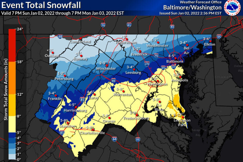
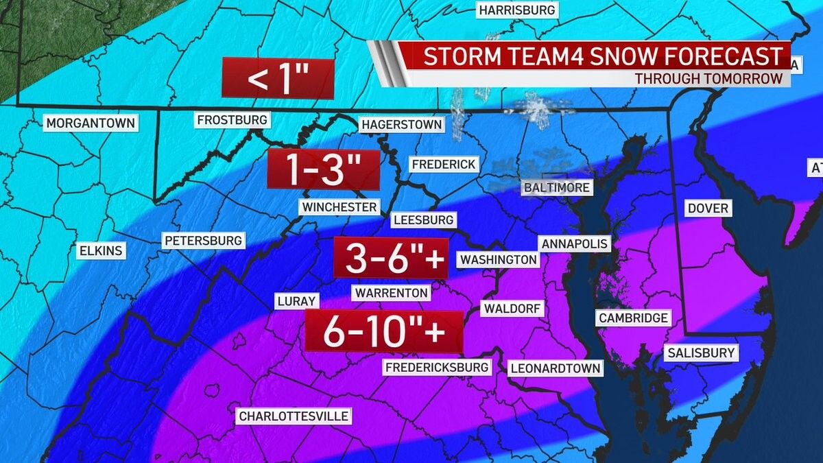
- Forecasters predict four to six inches of snowfall by Monday afternoon with the potential for more — with the largest total snowfall impact in 3 years.
- A winter storm warning is in effect across the region until 4 p.m. on Monday.
- A tight gradient of snowfall accumulation just north of the District means small nudges in the storm system’s path could lead to big differences in accumulation.
- The system is expected to bring dangerous driving conditions on Monday morning commutes.
A low-pressure system developing over Southern Appalachia is poised to bring snow from the Blue Ridge to the coastal Chesapeake Bay starting Sunday night. A series of winter storm warnings and snowfall were triggered as far south as Alabama, though last-minute shifts in the forecast could lead to locally higher or lower totals.
Monday morning in the D.C. area, some have already reported ice-mixed-rain in portions of Fairfax county, less than an hour ahead of winter storm warnings going into effect.
Here is a look at the snow here at NWS Huntsville. #HUNwx pic.twitter.com/HlYXkaVlHb
— NWS Huntsville (@NWSHuntsville) January 3, 2022
Sunday night, Storm Team4 meteorologists increased the predicted amount of snowfall, though the exact snow totals won’t be revealed until Monday afternoon.
Conor Bleak with the National Weather Service noted that these storms could create issues Monday morning travel for commuters in the District, Northern Virginia and Southern Maryland.
“We’re going to be dealing with rates potentially on the border of 1/2 inch to an inch an hour at the peak of the storm, and with those [kinds] of rates it’ll definitely cause some issues on the roadways,” said Connor Belak, a meteorologist at the National Weather Service. “Especially the elevated surfaces like bridges.”
Current Weather Warnings
The National Weather Service has issued a winter storm warning from 11 p.m. Sunday to 1 p.m. Monday for portions of Northern Virginia and from 1 a.m. to 4 p.m. Monday for the D.C. metro, Southern Maryland and Spotsylvania, Stafford and King George counties in Virginia.
Forecasters expect heavy snow late Sunday night through Monday afternoon, with total accumulations of between three and seven inches possible in D.C. and the close-in suburbs. The heaviest snowfall is predicted to be between 5 a.m. and 10 a.m.
Storm Team4 Meteorologist Matt Ritter told WTOP that poor driving conditions could extend into the Tuesday morning commute if the snow freezes overnight on Monday.
“We are going to have to worry about a hard freeze of whatever ends up on the ground, which will be compact, wet, and slushy regardless of amounts,” Ritter said.
The following counties in southern Maryland and central and northern Virginia could see snow accumulations of five to eight inches:
- Charles, St. Mary’s and Calvert in Maryland
- Stafford, Spotsylvania, King George in Virginia
The following counties and cities are expected to have snow accumulations of three to seven inches:
- D.C.
- The city of Baltimore, Prince Georges, Anne Arundel, Montgomery and Howard counties in Maryland
- The cities of Manassas, Manassas Park, Falls Church and Alexandria and Fairfax, Arlington, Prince William, Loudoun, Fauquier and Culpeper counties in Virginia.
This ups the message for the impacts for the heart of the @WTOP listening area. Impacts go into Monday afternoon. I still believe hard freeze Monday night is important to monitor! #DCwx #MDwx #VAwx #WashingtonDC https://t.co/3ELi5t7k1L
— Matt Ritter, WTOP Multimedia Meteorologist (@MetMattRitter) January 2, 2022
- Listen to WTOP online and on the radio at 103.5 FM or 107.7 FM.
- Current traffic conditions
- Weather forecast
- Closings and Delays
- Sign up for WTOP alerts
Previous forecasts have changed dramatically
Monday’s forecast had called for little more than flurries a day ago, but a dramatic shift in computer models on Sunday morning has put the immediate D.C. region under a distinct risk for something much more significant.
The culprit — a rapidly deepening storm front moving out from the Tennessee Valley over the Carolinas — will bring moisture into the D.C. area from west to east after midnight. While a mix of rain and sleet could kick things off, overnight temperatures should be cool enough for a prolonged period of snow lasting past daybreak.
“As the colder air continues to spill into the region from the north, that rain will switch over to sleet and then eventually from sleet as the air continues to get colder and colder will change over to snow,” Storm Team 4 meteorologist Ryan Miller told WTOP.
But as with so many winter storms in recent memory, there’s a catch: Models are hinting at a tight gradient of snowfall accumulation just north of the nation’s capital, meaning small nudges in the system’s path throughout Sunday could lead to big differences in exactly how much falls — and where. The precise setup of heavier snow bands are also notoriously difficult to predict, and that too could be a determining factor.
“This is a type of storm that is going to be on the coast and there’s going to be a tight gradient between where the precipitation falls and where there’s going to be nothing,” Miller said.
The take-away is that the forecast is likely to change somewhat, but whatever results will more than likely prove a headache for anyone hitting the road on Monday morning. Plan for slippery conditions on streets, steps, sidewalks and driveways regardless of how much snow ends up falling.
Responses from the region
Anticipating dangerous conditions, crews are getting ready to deploy overnight to lay salt and plow whatever snow does fall. D.C. Mayor Muriel Bowser has since declared a snow emergency and will send out a team of more than 100 snowplows at midnight. The city will also start treating roads with salt at that time.
In Maryland, crews are loading up rock salt and will head out once the precipitation starts. Charlie Gischlar, community relations manager with the Maryland Department of Transportation, State Highway Administration, said they’ll begin with salt and then start plowing.
But because the storm is expected to start as rain, he said they can’t pre-treat the roads effectively.
“All the material would just simply wash off the roadway. So now we’re just going to be loaded up and ready to go.”
Ellen Kamilakis, a spokesperson with the Virginia Department of Transportation, said their crews will start mobilizing overnight.
“They get their map assignments as to which area they’re going to be plowing, they get filled with salt or sand depending upon where they’re going to be. And then they go off to wait for the storm to begin,” she said.
She said their plows will drop blades down and actually start to push the snow once there are two inches of accumulation on the ground.
Forecast:
Sunday night: Cloudy skies. Winter storm warning starts overnight at 1 a.m. until 4 p.m. Monday. Rain mixing with snow after midnight. Chance of rain/snow 100% (mainly after midnight). Lows in the mid-20s to mid-30s.
Monday: Winter storm warning continues until 4 p.m. Snow, moderate at times. Accumulations three to five inches in the D.C. metro and high accumulations south and east. Snow early / late afternoon, 100% chance. Northwest wind of 15 to 25 miles per hour becoming northwest 25 to 30 miles per hour with higher gusts south and west of town. Highs in the low to mid-30s.
Tuesday: Sunshine continues. A bit warmer and breezy with a northwest wind of 10 to 20 miles per hour. Highs in the mid-30s to 40 degrees.
Wednesday: Partly cloudy and a touch warmer. Breezy with a southwest wind of 10 to 15 miles per hour. Highs between 37 and 45 degrees.
Current conditions:
WTOP’s Valerie Bonk contributed to this report.