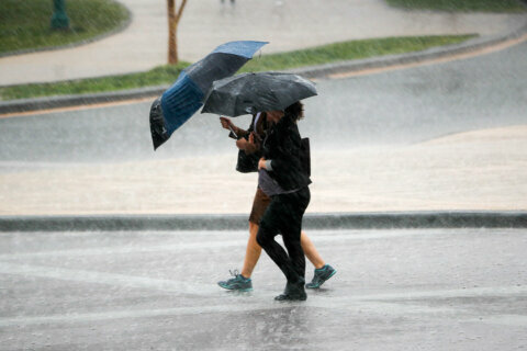
Snow that left minimal dusting for much of the region has moved toward the northeast, leaving slick patches of ice and brisk winter weather.
Key points:
- A winter weather advisory was canceled for large portions of the D.C. area early Saturday morning.
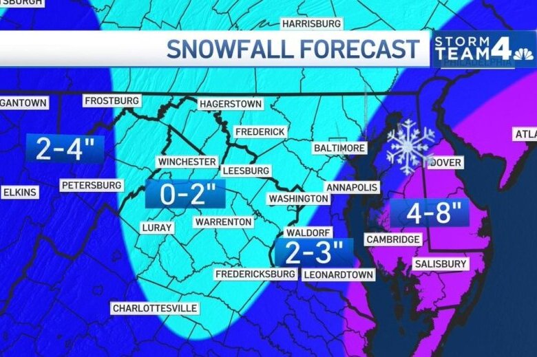
- Snow totals landed at around an inch for much of the area, with southern Maryland topping out at roughly four inches.
- Virginia and Maryland each declared a state of emergency ahead of the winter storm.
The National Weather Service canceled a winter weather advisory for most of the D.C. area just before 3:30 a.m. on Saturday.
Some Maryland counties saw snow throughout the morning. Southeast Harford and Cecil Counties were under a Winter Weather Advisory until 11 a.m.
The greatest snow totals will be in southern Maryland but windchill temperatures will be in the single digits across the region Saturday.
It’ll also be windy across the board Saturday with Stinneford predicting gusts over 40 mph at times. High winds combined with flurries could create issues including reduced visibility during travel.
Storm Team4 meteorologist Steve Prinzivalli predicted that the D.C. area would approach these snow totals as the sizable storm headed toward the New England coast.
Impact to commutes
WTOP’s traffic reporter Ian Crawford recommended that drivers stay off the road Saturday morning. He said while most major interstates around D.C. are wet, there’s lots of snow on the roads in southern Maryland.
“It is not your normal wet morning drive in the middle of winter,” Crawford said.
Prinzivalli said that he expected a mixture of wind and snow to create issues not just for icy roads but visibility while driving.
WTOP’s Mary DePompa: Weather will dictate traffic this weekend
Charlie Gischlar, an official at the Maryland State Highway Administration, told WTOP that drivers should avoid driving unless necessary as well.
“Best practice we always tell people is if you can avoid it, reduce travel,” Gischlar said.
Bridges and overpasses could refreeze overnight.
“Everything that was wet on the roadways, that is starting to freeze,” Stinneford said.
Staying off the roads can give time for utility crews to treat the roads as some may have iced over.
We’re urging motorists to delay their travels today while our crews work to clear roadways. If you must travel, check current road conditions before you leave your home. Visit https://t.co/6ZNb3OOhql to view our cameras. #mdotsafety #mdWx tr pic.twitter.com/adEvanHntr
— MD State Highway Adm (@MDSHA) January 29, 2022
If you do have to travel, the MDOT website has information on roads that have been plowed and are safer to drive on.
States prepare for another round of snow
Virginia Gov. Glenn Youngkin and Maryland Gov. Larry Hogan also became two of five governors to declare a state of emergency because of severe weather. The District has dispatched its snow team and Maryland has mobilized the state’s National Guard.
The emergency declaration included Maryland’s Caroline, Cecil, Dorchester, Kent, Queen Anne’s, Somerset, Talbot, Wicomico and Worcester Counties. An expanded blizzard warning also went into effect for Somerset, Wicomico and Worcester Counties.
- Listen to WTOP online and on the radio at 103.5 FM or 107.7 FM.
- Current traffic conditions
- Weather forecast
- Closings and Delays
- Sign up for WTOP alerts
Forecast:
Saturday: Light snow ending in the early morning. Total accumulations of 1” to 4.” Windy and very cold the rest of the day with a mix of clouds and sun and scattered flurries. Highs: mid 20s to near 30. Wind chills in the single digits and teens.
Sunday: Mostly sunny. Cold but not as windy. Highs: upper 20s to low 30s.
Monday: Mostly cloudy. More seasonably chilly. Highs: low 40s.
Current conditions:
Power outages:
WTOP’s Ivy Lyons contributed to this report.