A week of frigid temperatures is in store for the D.C. area after three rounds of winter weather, with wind chills below 20 degrees in Monday’s forecast.
A cold front that brought a soaking rain to portions of Northern Virginia and Maryland sent overnight lows plummeting, causing meltwater to refreeze. Monday morning commuters luckily won’t have to worry about snow or freezing rain, but black ice will remain a major concern on untreated surfaces.
“Temperatures will fall below freezing across the entire region by dawn Monday morning. This will result in patchy ice from the lingering moisture from Sunday`s rain and melting snow,” the National Weather Service said. “Early morning motorists should use caution and consider that any surface appearing to be wet may in fact be icy.”
For the latest road and traffic conditions, see WTOP’s traffic page or listen to updates every 10 minutes online or on the air at 103.5 FM. Download the free WTOP News app for Android and Apple phones to sign up for custom traffic and weather alerts.
- Listen to WTOP online and on the radio at 103.5 FM or 107.7 FM.
- Current traffic conditions
- Weather forecast
- Closings and Delays
- Sign up for WTOP alerts
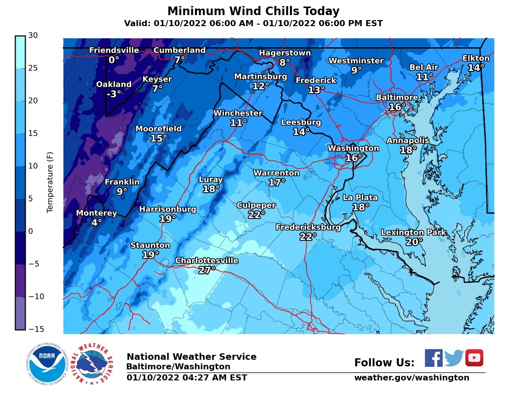
While this week’s outlook has most of the D.C. region steering clear of new snowfall, the main story will be bitterly-cold gusts.
Strong northwesterly winds in the wake of Sunday’s cold front will cause wind chill values to dive into the teens on Monday and Tuesday, with single digits for the higher elevations of West Virginia and far Western Maryland. High temperatures on both days — not factoring in the wind — are unlikely to make it far above freezing.
“That steady wind will stay up overnight Monday as temperatures fall into the 10s and low 20s,” Storm Team4 meteorologist Chuck Bell said. “Tuesday will be the coldest day of the week with most areas staying below freezing the entire afternoon.”
Forecast:
Monday: Sun and clouds, windy and cold. Daytime chills in the mid 20s and no chance of ice or rain. Winds northwest at 15 to 30 mph. Highs of 30 to 35 degrees.
Monday night: Mainly clear skies, windy and cold with wind chills near 10 degrees. No chance of rain and Winds northwest 12 to 22 mph. Lows of 15 to 22 degrees.
Tuesday: Mostly sunny, breezy and cold with daytime chills near 20 degrees. No chance of rain or snow and winds northwest at 10 to 20 mph. Highs of 28 to 32 degrees.
Wednesday: Sunny morning with some afternoon clouds and not as cold. No chance of rain and wind southwest at 5 to 15 mph. Highs of 40 to 46 degrees.
Thursday: Mostly cloudy and seasonable with a light breeze. No chance of rain northwest 4 to 8 mph. Highs of 42 to 48 degrees.


