The forecast continues to call for winter weather impacts in the D.C. region Friday evening through Saturday, although odds of a blockbuster event are falling for urban areas.
Still, Virginia Gov. Glenn Youngkin is taking no chances and declared a state of emergency due to the severe winter weather, which will run until Feb. 26.
The name of the game for the next few days will be frigid temperatures — likely the season’s coldest yet — punctuated by a coastal storm paralleling the East Coast and phasing together with a cold front moving in from the Great Lakes.
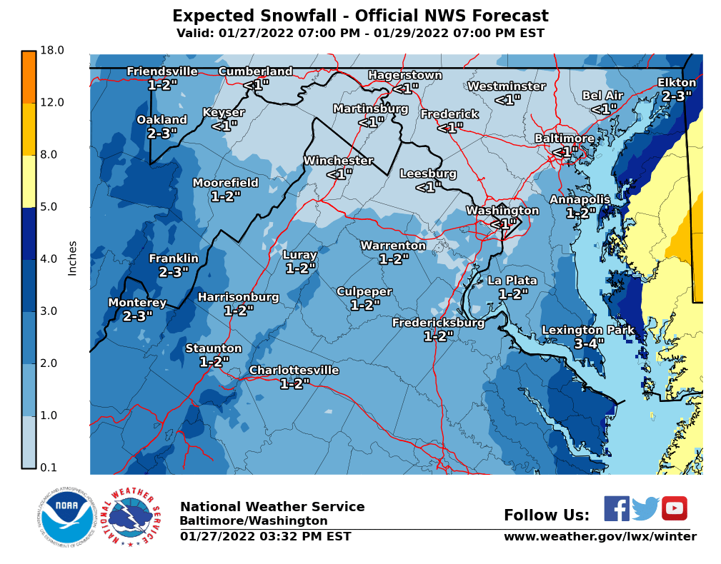
Models nudged eastward overnight. While the latest thinking still puts Maryland’s Eastern Shore, Delaware and much of coastal New England under the bullseye for between 4 and 9 inches of snow, D.C. and Baltimore are in for a more manageable 1 to 4 inches. Keep in mind that the forecast could still trend up or down with even minor shifts in the storm’s projected path.
The bottom line: Expect light snow to move in after sunset Friday. Urban areas will wake up to snow on the ground Saturday with precipitation tapering off late morning, while parts east of the Chesapeake Bay are in for a more prolonged, high-impact event stretching well into the evening. Regardless of where you are, avoid travel during the height of the storm.
“Even though the D.C. metro will not be getting the most snow, wide-ranging impacts on travel are still expected from D.C. to New York to New England this weekend,” Storm Team4 meteorologist Chuck Bell said. “If your travel plans are flexible enough to go today or early Friday, or wait until Sunday afternoon, make those changes now.”
- Listen to WTOP online and on the radio at 103.5 FM or 107.7 FM.
- Current traffic conditions
- Weather forecast
- Closings and Delays
- Sign up for WTOP alerts
Conditions in the Delmarva will be treacherous as Saturday’s storm intensifies off the coast: In a Winter Storm Watch for the Eastern Shore, the National Weather Service noted winds of up to 40 mph could generate areas of blowing snow and reduce visibility at times.
But residents of the Interstate 95 corridor look to dodge the worst from Saturday’s event. Slush on roads, black ice and an Arctic blast will be the main story from the cities to the west along the Blue Ridge. If you must be on the roads Friday night into Saturday evening, use extra caution on untreated bridges, highway ramps, overpasses and driveways.
Icing was already snarling traffic for thousands on Thursday morning — slippery surfaces forced rush hour traffic on the Capital Beltway’s Inner Loop to divert before the American Legion Bridge in Northern Virginia. A traffic camera from the Virginia Department of Transportation showed crews salting the Beltway under the George Washington Parkway.
McLean: 495NB (Capital Beltway Inner Loop) at GW Pkwy: All lanes temp closed while crews on-scene treat ice. pic.twitter.com/w40Naacztq
— VDOT Northern VA (@VaDOTNOVA) January 27, 2022
“With the storm staying well off our coastline, higher snow totals will be more likely in Southern Maryland and on the Eastern Shore, and low amounts along and west of the Blue Ridge,” Bell said. “To be honest, this will be an excellent weekend for snow skiing in West Virginia and Western Maryland, if you feel like heading west today or early Friday.”
Saturday afternoon brings us bitter cold and a howling gale. The storm’s last flurries clear the region by sunset — but blowing snow and wind chills near or below zero will make the outdoors hazardous for the unprepared. Wind chill values could reach 10 to 20 degrees below zero early Sunday morning in the higher elevations of Northern Maryland and Virginia’s Blue Ridge.
Forecast:
Thursday: Mostly sunny and staying cold with daytime chills in the mid-20s and a 0% chance of snow. Winds south at 5-10 mph and highs of 34-40 degrees.
Thursday night: Becoming cloudy, cold and dry with a light breeze. A 0% chance of snow with variable winds at 5 mph. Lows of 24-30 degrees.
Friday: Cloudy and cold with light rain and snow becoming all snow after sunset. An 80% chance of rain or snow with wind north at 5-10 mph. Highs of 34-38 degrees.
Saturday: Snow in the morning with accumulations of 1-4 inches possible. Will become very windy, with bitter cold daytime chills of 5-15 degrees. An 80% chance of snow with wind northwest at 20-35 mph. Highs of 20-26 degrees.
Sunday: Cold with sun, clouds and wind dying down. A 0% chance of snow and wind northwest at 5-15 mph. Highs of 26-32 degrees.


