The final weekend of August in the D.C. area will be sunny, hot and muggy, with a chance for showers and storms. Here’s what you need to know.
Storm Team4 meteorologist Mike Stinneford said he expects a weak front will stall across the region over the weekend, keeping weather unsettled.
Saturday will be partly sunny, hot and muggy, with temperatures soaring to near 90 degrees with heat indexes approaching 100 degrees, Storm Team4 meteorologist Steve Prinzivalli said.
“Once again, we may have a few more showers and storms Saturday. So keep an eye on the sky and be sure to move inside and away from windows when you hear thunder,” Prinzivalli said.
Sunday will bring similar weather with a partly sunny sky and perhaps an isolated shower or storm.
“We will watch for a hurricane to impact the Gulf Coast on Sunday, and this storm could eventually bring some tropical moisture to the region,” Stinneford said, adding that a cold front may bring some relief to the region’s high temperatures by the middle of next week.
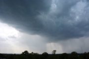
On Friday, severe weather rolled through the area prompting a flash flood watch for parts of D.C., Maryland and Virginia through the late evening.
Severe thunderstorm warnings were issued throughout the region, as the afternoon commute got underway. Thunderstorms with damaging winds and heavy rain rolled across the region, downing trees, power lines and causing flooding in some spots.
The activity diminished Friday night, with some chance for a few leftover storms before midnight, remaining muggy overnight.
This is currently the third-wettest August for D.C. recorded since 1991, Storm Team4 meteorologist Briana Bermensolo said. “(Friday’s) rain may push us right into the top 10 wettest Augusts ever recorded before the month is even over.”
- Listen to WTOP online and on the radio at 103.5 FM or 107.7 FM.
- Current traffic conditions
- Weather forecast
- Closings and Delays
- Sign up for WTOP alerts
Traffic and damages
Three people, including a child, were rescued from a car that had a tree and utility wires land on it in Silver Spring. It happened Friday on Columbia Boulevard. Montgomery County Fire and Rescue Service Assistant Chief David Pazos said one person has been taken to the hospital.
A couple of people were stuck in high water near Broad Branch Road at Soapstone Creek in D.C. Callers also reported to the WTOP Traffic Center that a tree hit a car on the George Washington Parkway ramp to the Inner Loop, and that the ramp to westbound Clara Barton Parkway had been blocked by a downed tree.
Current weather
Forecast
The new workweek will start steamy before turning cooler and very wet. Both Monday and Tuesday will be partly sunny, hot and muggy, with highs soaring to near 90 and heat indexes of 100.
There will be a continued risk of daily showers and gusty thunderstorms; any storms could contain downpours and dangerous lightning.
Hurricane Ida is expected to make landfall on the Gulf Coast Sunday as a major hurricane. It will then track northeastward and bring flooding rain to the Tennessee Valley, Central Appalachians, and Northeastern U.S. This will lead to a very soggy time Tuesday night into Wednesday, with an enhanced flooding threat as the remnants of Ida march through the area, Prinzivalli said.
Friday night: Scattered showers/storms, mainly before midnight. Muggy, warm and partly cloudy. Some Storms strong to severe. Lows in the Low to Mid 70s.
Saturday: Partly sunny, hot and humid. Scattered afternoon showers/storms. Highs in the mid 80s to low 90s. Heat index: Near 100.
Sunday: Partly sunny, hot and umid. Isolated afternoon shower/storm. Highs in the mid to upper 80s. Heat index: mid 90s.
Monday: Partly sunny, hot and still muggy. Scattered afternoon showers/storms. Highs around 90. Heat index: Near 100.
Tuesday: Partly sunny, hot and humid. Scattered afternoon showers/storms. Highs around 90. Heat index: Near 100.
WTOP’s Abigail Constantino contributed to this report.