Torrential downpours overspread the D.C. region overnight from Saturday into Sunday, flooding streets and stranding vehicles in the Alexandria area of Virginia.
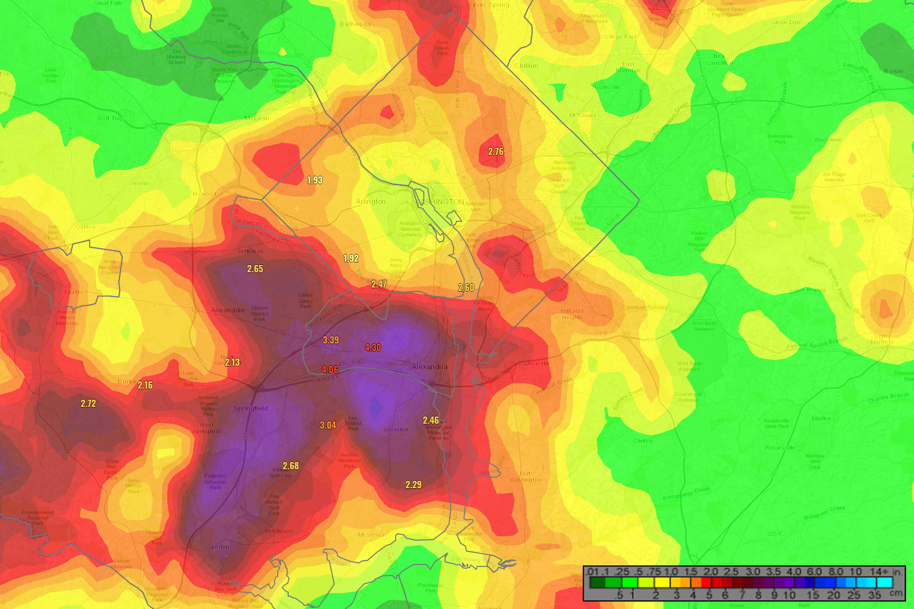
Storms appeared just before midnight, taking advantage of an energized, waterlogged air column amid weak atmosphere steering. The result: Slow-moving thunderstorms that dumped well over two inches of rain over parts of the region, causing flash floods from Alexandria to Arlington.
Portions of King Street, Prince Street and Richmond Highway were closed for high-standing water. A stream gauge along Cameron Run at Eisenhower Avenue measured a water level rise of eight feet in under an hour, cresting four feet above its flood stage.
- Listen to WTOP online and on the radio at 103.5 FM or 107.7 FM.
- Current traffic conditions
- Weather forecast
- Closings and Delays
- Sign up for WTOP alerts
Emergency managers reported vehicles trapped in rising waters on the northbound ramp from Interstate 495 to I-95, and along eastbound Arlington Boulevard around Route 7. Various lanes were blocked by flooding along northbound I-395 around Va. Route 120.
Alexandria and adjacent areas of Arlington and Fairfax counties saw between three and five inches of rain before the night was done. The District, Prince William and Loudoun counties — which were also under flash flood warnings early Sunday — ended up with between one and three inches of rainfall.
Images shared with WTOP showed floods overwhelming storm drains near the Braddock Road Metro station:
@DrainALX severe flooding in the Braddock Metro Neighborhood at Braddock/N West/Wythe Street 15 August 2021. City of Alexandria VA pic.twitter.com/cdCMVioBAn
— John (@John16291770) August 15, 2021
Alexandria resident John Craig said floodwaters at their highest point across from the Braddock Road Metro Station were “about three and a half to four feet deep.”
Graig, who lives in west Old Town, said his basement flooded and he had over two feet of water against the foundation of the front of his house.
“I’ve lived here for 20 years and flooding has been a problem longer than I’ve lived here and the city has known about it … the city won’t do anything about it,” he said.
Craig said that while Alexandria is working in other neighborhoods to “fix the problem,” it would need to increase the capacity of the storm drain sewers “and that’s going to cost them a lot of money — they’re really reluctant to do that.”
For the latest road and traffic conditions, see WTOP’s traffic page or listen to updates every 10 minutes online or on the air at 103.5 FM. Submit traffic tips by calling 866-304-WTOP or tagging @WTOPtraffic on Twitter.
Gut wrenching. #DrainALX #FixthepipesALX pic.twitter.com/HIJKwwmULj
— DrainALX (@DrainALX) August 15, 2021
Forecast:
Sunday: Mostly cloudy, lower humidity, but still humid south of D.C. in some areas. Spotty showers with a thunderstorm or two possible. Temperatures around 80.
Sunday night: Areas of rain, with a storm possible as humidity returns. Temperatures in the 60s and 70s.
Monday: Mostly cloudy and muggy, with showers and storms possible. Temperatures in the lower 80s.
Tuesday: Mostly cloudy and humid, with storms possible. Temperatures in the lower 80s.
Wednesday: Cloudy with storms possible. Humid. Temperatures in the lower 80s.
Current conditions:


