Icy, rainy weather rolled into the D.C. area Monday evening, ahead of another potential winter storm later this week.
Storm Team4 meteorologist Matt Ritter Monday night’s “icy mix” could slow down travel into Tuesday morning.
Snow accumulation ended about 9 p.m., Storm Team4 meteorologist Mike Stinneford said, but because temperatures are falling, roads could be slick for the next few hours.
Lighting freezing rain and sleet will continue in the northern suburbs, and the southern part of the region will receive rain.
The rain will end Tuesday morning, Stinneford said.
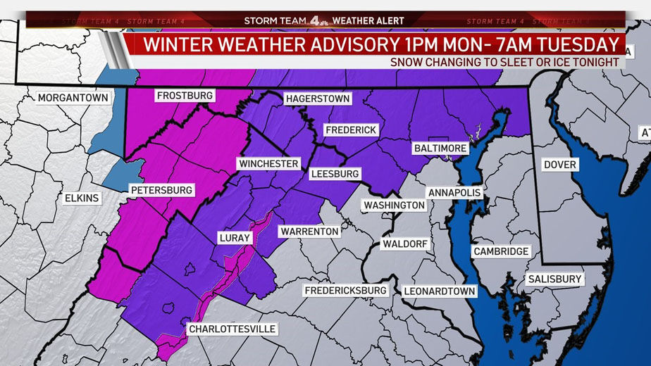
The Winter Weather Advisory is in effect until 10 a.m. Tuesday in D.C. and the immediate metro area, as well as northern Loudoun and Fauquier counties in Virginia, and northern Maryland.
Winter Weather Advisory for our areas shaded in purple this evening through mid-morning. Mostly after rush hour, mix will move in and changeover to all snow, then change back to sleet/freezing rain before midnight. Not big snow numbers but enough icy glaze for slow travel. @WTOP pic.twitter.com/O50oJfbfZu
— Matt Ritter, WTOP Meteorologist #DCwx #VAwx #MDwx (@MetMattRitter) January 25, 2021
Ritter said Northern Virginia, the immediate D.C. area and Northern Maryland will see an inch or two of snow before the changeover.
Montgomery, Howard and Frederick counties in Maryland, and parts of the Interstate 81 corridor, are under a winter weather advisory. Icy conditions are expected to be worst in the Shenandoah Valley, which will be under a winter storm watch until 10 a.m. Tuesday. Temperatures will top out in the upper 30s.
For areas north of U.S. Route 50 in Maryland, precipitation will slowly change to freezing rain before switching over to a wintry mix. With warmer air, snow will switch over to sleet before rain returns around noon Tuesday.
Areas with sheltered valleys, where the cold air will linger the longest, could experience six to eight hours of freezing rain. Montgomery and Frederick counties — as well as the deepest parts of the Shenandoah and northern Loudoun County in Virginia — are more at risk for icy conditions Tuesday.
– A wintry mix starts 3 to 5PM today.
– A burst of heavy snow is possible in the DC Metro and esp north/west of DC Metro 6-10PM.
– Change over to mainly freezing rain and rain overnight
– Ice accumulation possible north/west of metro
– Slick roads tonight, chc slick Tue AM pic.twitter.com/8R3UPGedmY— Amelia Draper (@amelia_draper) January 25, 2021
“Either way, it is going to be messy to travel through this evening into the overnight and through tomorrow morning,” said Storm Team4 meteorologist Lauryn Ricketts. “While most areas should experience plain rain by Tuesday morning, there could be some pockets of freezing rain, especially north and west of D.C.”
Because areas along the Pennsylvania line may see between 2 to 4 inches of snow Tuesday, the Maryland Department of Transportation State Highway Administration is asking drivers to stay home during the storm. In a statement, it said it has prepared enough equipment and supplies to keep roadways clear.
Up to 387,000 tons of rock salt will be used to treat the roads once the snow begins to fall.
Winter weather is in the forecast this week—remain vigilant if you are in a region that may be impacted. #MdWx
– Road conditions may be icy, so take extra precaution when commuting. ❄️⚠️🚙
– Power outages are possible; be sure to charge your mobile devices ahead of time 🔋📲✔️ pic.twitter.com/6VVto92g3w— Maryland Emergency Management Agency (MDMEMA) (@MDMEMA) January 25, 2021
Conditions will dry out by Tuesday afternoon, but the region will then be bracing for a potential winter storm that could start Wednesday night into Thursday morning. Snow showers are in the forecast for Thursday morning, Ricketts said. But with the storm system coming from the south, snow accumulation chances are lower.
Instead, Thursday’s weather may bring wind gusts that reach up to 30 mph and wind chills in the teens and 20s.
Closings and Delays
Several D.C.-area school systems announced delayed openings for Tuesday as a result of the winter weather.
Prince William County schools in Virginia and Carroll County schools in Maryland will both open two hours late.
Howard County, Maryland, schools will continue with virtual learning as scheduled.
And first shift workers at FBI Winchester have a two-hour delay.
Check for additional updates at WTOP’s Closings and Delays page.
- Listen to WTOP online and on the radio at 103.5 FM or 107.7 FM.
- Current traffic conditions
- Weather forecast
- Closings and Delays
- Sign up for WTOP alerts
Forecast
Monday
- Monday night: freezing rain turning into a wintry mix overnight.
- Highs in the 30s to around 40.
Tuesday
- Wintry mix starting with freezing rain.
- Switches over to sleet, then rain.
- Snow at higher elevations.
- Highs in the low to mid-40s.
Wednesday
- Mostly cloudy.
- Rain switches over to snow overnight.
- Highs in the mid-40s.
Thursday
- Periods of snow.
- Cloudy day with winds reaching 15 to 25 mph.
- Highs in the mid-30s.