Virginia Gov. Ralph Northam has declared a state of emergency ahead of Hurricane Isaias, which could bring heavy rain and gusty winds from coastal Virginia through Maryland’s Eastern Shore early next week, with D.C. eyeing a flood risk.
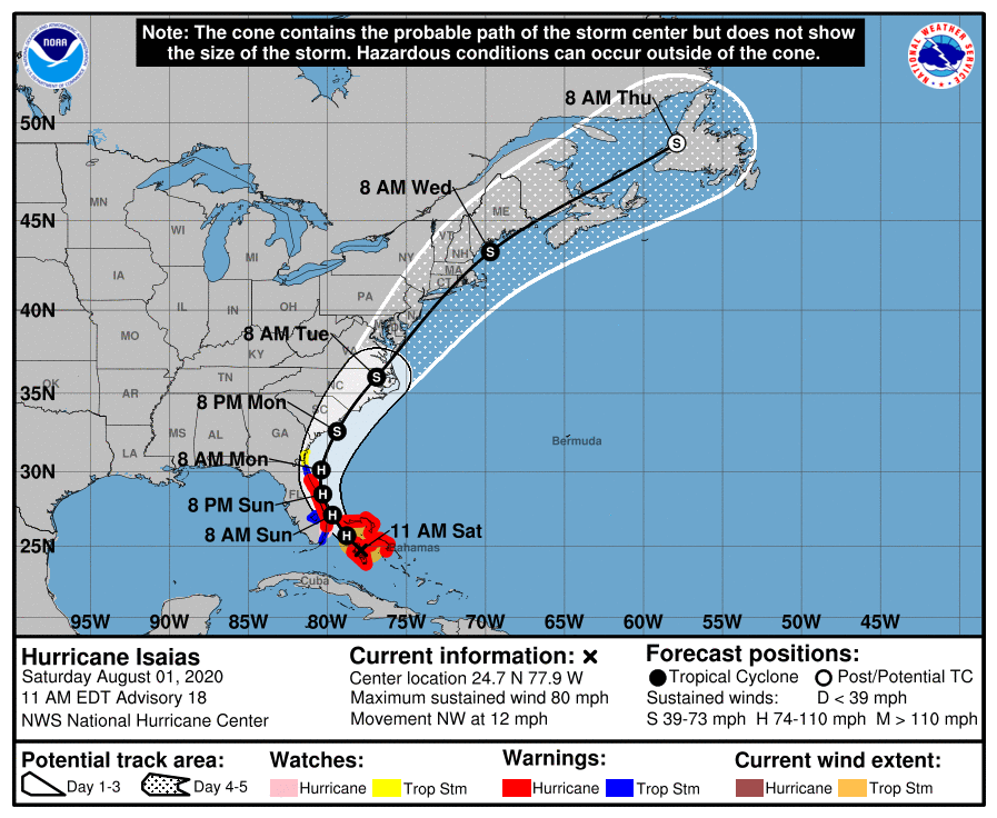
Isaias was bringing strong winds and high swells to the western Bahamas on Saturday morning, with Florida next in line on Sunday.
As of Saturday evening, Isaias was downgraded to a Tropical Storm, according to the National Weather Service.
Although the National Hurricane Center doesn’t foresee significant strengthening as the storm pivots northward and parallels the U.S. East Coast from Sunday through Tuesday, the mid-Atlantic to New England are likely to see some rough weather.
While Isaias’ path is still uncertain, it appears increasingly likely that eastern Virginia could be impacted and must prepare for the possibility of flooding, high winds and potential storm surge, a news release from Northam’s office said.
The primary threat for the D.C. area is severe storms bringing damaging winds, downpours, hail and the possibility for an isolated tornado on Saturday, according to Storm Team4 meteorologist Somara Theodore. The threat grows west of I-95 and even south of D.C. The unsettled weather will continue even after the sun sets.
Some showers and storms linger into the night but flooding or evening localized flash flooding can’t be ruled out, Theodore says.
There is about a 30% chance of storms through out the day on Sunday and some storms could turn severe, Theodore says.
Isaias is expected to be a strong tropical storm by Monday, according to Theodore.
As of Saturday, the official track for Isaias had the storm making landfall west of Cape Hatteras early Tuesday before emerging back into the Atlantic and racing northeastward, just off the Virginia shore, through Wednesday.
Isaias is forecast to remain a Category 1 hurricane or strong tropical storm while skirting the coastline.
A nudge to the east would limit most impacts to Florida and the Carolinas, while a more westward track through the Chesapeake would bring a significant flood risk into the immediate D.C. region around Tuesday.
While both are distinct possibilities to be aware of, Storm Team4 meteorologist Lauryn Ricketts forecasts Isaias to pass just east of the D.C. region by Monday or Tuesday.
“Expect rain chances to increase on Monday as temperatures rise to the 80s. Rain likely through the day on Tuesday and it could be steady at times,” said Ricketts.
D.C. Mayor Muriel Bowser asked residents Friday night to prepare for the possibility of heavy rain and wind activity from Isaias early next week.
Bowser said in a news release that the D.C. Homeland Security and Emergency Management Agency had begun emergency planning with its local, regional and federal partners; and more information will be provided as the hurricane’s trajectory becomes more precise.
The Virginia Hurricane Evacuation Guide During the COVID-19 Pandemic outlines preparedness, response and recovery actions, and Northam urged Virginians in coastal areas who may be affected to consult it in making their preparations.
For more on hurricane preparation, go to the FEMA website. Find more tips on the Ready DC website and the Virginia Department of Emergency Management.
WTOP’s Alejandro Alvarez and The Associated Press contributed to this report.