
Another round of severe weather is in store for the entire D.C. region leading up to Memorial Day, with forecasters warning of strong storms with a potential for hail and damaging winds on Sunday afternoon before a hot and humid pattern closes out the holiday weekend.
The National Weather Service urged anyone with outdoor plans to pay close attention to the latest forecast all afternoon, with the best chance for severe weather Sunday evening through midnight.
- Listen to WTOP online and on the radio at 103.5 FM or 107.7 FM.
- Current traffic conditions
- Weather forecast
- Sign up for WTOP alerts
Warnings & Watches
All severe thunderstorm warnings across the D.C. region have been canceled as of 10:30 p.m.
The National Weather Service also canceled a severe thunderstorm watch for the areas, which was previously in effect until 1 a.m.
The strong to sever thunderstorms will be scattered around the listening area into the early nighttime hours, according to Storm Team4 meteorologist Matt Ritter. Damaging wind gusts and large hail are the primary threats, but localized flooding are also possible.
Storms are becoming more numerous along the line from near Warrenton all the way through the District into Prince George’s County. We’re expecting even more to develop late this evening as the cold front approaches from PA and WV. Stay with @wtop and @nbc4dc pic.twitter.com/YWVl8IsEo0
— Matt Ritter, WTOP Wx (@MetMattRitter) May 26, 2019
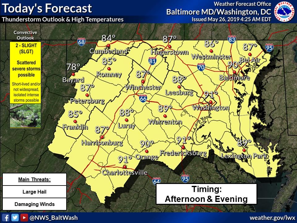
NOAA’s Storm Prediction Center placed the entire D.C. region under a “slight risk” for severe weather, the second of four ranks for severe weather threats from “marginal” to “high.” While a severe weather outbreak like what the area saw last week seems unlikely, it’s enough of a threat to potentially cut holiday activities short with little notice.
“The message for the day — especially for those outdoors — is to stay weather aware and be prepared for rapidly changing conditions,” the weather service said in its Sunday forecast discussion. “If you see lightning or hear thunder, you are close enough to be in harm`s way.”
Pop up thunderstorms will be likely this afternoon with widespread thunderstorms likely this evening through midnight. These storm have the potential to be strong to severe and produce strong winds and large hail. pic.twitter.com/rpXou3ZKTJ
— NWS DC/Baltimore (@NWS_BaltWash) May 26, 2019
A storm threat will persist through Memorial Day, with a slight chance of lingering storms through the afternoon as a cold front slips through from the northwest.
Another round of severe weather is possible Tuesday, with a humid air mass and unstable atmosphere will combine for a wind and hail threat — and another chance for tornadic activity, less than a week after a tornado warning placed the nation’s capital on edge.
The rest of the week will be scorching hot: A heat wave will have temperatures soaring through the mid to upper 90s in the immediate D.C. area, with talk of record daytime highs from central Virginia into the Southeast.
Forecast:
Sunday: Showers and thunderstorms likely after 2 p.m. Some storms could be severe. Otherwise, partly sunny and hot, with highs near 90.
Sunday night: Strong storms likely before 11 p.m. Cloudy after midnight, with lows in the upper 60s.
Memorial Day: A 40% chance of showers and thunderstorms. Otherwise, partly sunny, with highs in the low 80s.
Tuesday: A slight chance of showers and thunderstorms. Mostly cloudy, with highs in the upper 80s.
Wednesday: Sunny and hot. Highs in the mid 90s.


