
A low pressure system racing northward through the Carolinas will send alternating rounds of rain and snow into the D.C. region from late Sunday morning into the overnight hours on Monday.
Wintry weather will make an impact in the D.C. area starting Sunday afternoon and evening with a mix of snow, sleet and rain, the National Weather Service said.
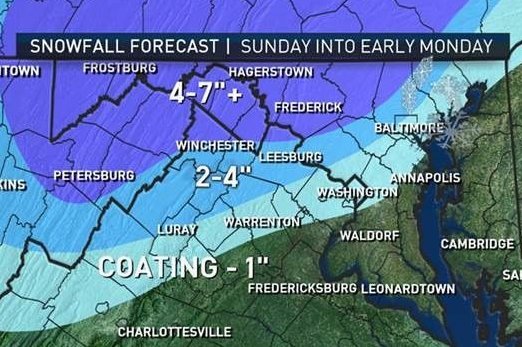
Affected areas include, Annapolis, D.C., Upper Marlboro in Maryland, and Fairfax, Fredericksburg, and Charlottesville in Virginia.
- Listen to WTOP online and on the radio at 103.5 FM or 107.7 FM.
- Current traffic conditions
- Weather forecast
- Closings and Delays
- Sign up for WTOP alerts
Storm Team 4 Somara Theodore says the system is expected to come into the region around brunch time.
“The D.C. metro area will teeter along that rain snow line. Therefore, what may start off as some snow fall will quickly change to a mix including sleet and rain then as the (temperatures) drop Sunday night, that could change back to snow before it heads out early Monday morning,” Theodore said.
What NBC Washington’s Lauryn Ricketts called a “tug of war” between a colder air mass over the Great Lakes and a warmer current from the Gulf of Mexico will lead to precipitation bouncing back and forth from rain to snow somewhat unpredictably starting late Sunday morning.
“D.C. will be playing tug of war between cold and warm air, therefore the Washington area will likely be changing back and forth from snow to rain through the duration of this evening,” NBC meteorologist Lauryn Ricketts said. “Areas north and west will be all snow, and locations south and east will stay all rain.”
Winter Storm Warnings go into effect for our far western and northern suburbs Sunday morning through Monday morning. Winter Weather Advisories for lesser snow impact border the warnings. Much less snow and much more rain along I-95 areas and south. @WTOP pic.twitter.com/NcHVDkAsi0
— Met. Matt Ritter (@MetMattRitter) March 2, 2019
Temperatures dropping after midnight on Monday may cause disruption for the morning commute.
Warnings and watches:
A winter storm warning has been issued from 10 a.m Sunday until 2 a.m. Monday for areas in the farther north portion of the WTOP listening area like Frederick, Northern Loudoun, northern Montgomery and northern Howard counties. Those areas could see 4 to 6 inches of snow.
A winter weather advisory has been issued for parts of the D.C. metro area including central Montgomery, Howard and Loudoun counties beginning at noon Sunday and continuing until 4 a.m. Monday. Snow may accumulate anywhere from 1 to 3 inches.
Winter Storm Warnings have been expanded to include western MD, and portions of eastern WV and northern VA. Precipitation will spread across the area Sunday morning and continue into Sunday night. Latest forecast: https://t.co/ZOlvESgJ2H. #DCwx #MDwx #VAwx #WVwx pic.twitter.com/SeEZiAiGTk
— NWS DC/Baltimore (@NWS_BaltWash) March 3, 2019
Areas under the winter weather advisory are likely to see snow covered roads and issues with the Monday morning commute.
The system will then depart quickly and bring about plenty of sunshine and breezy conditions for the next following days.
The next week should be dry, though another disturbance will bring rain next weekend, said Theodore.


