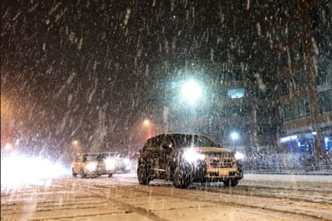

WASHINGTON — Some rain and snow showers Thursday night have prompted a number of D.C.-area school systems to announce delays or closings for Friday, with the morning commute expected to be messy.
- Listen to WTOP online and on the radio at 103.5 FM or 107.7 FM.
- Current traffic conditions
- Weather forecast
- Closings and delays
- Sign up for WTOP alerts
Rappahannock County, Prince William County and Fauquier County public schools are closed Friday. Schools in Virginia’s Arlington County, Culpeper County, Spotsylvania County, Stafford County, Fredericksburg City and Alexandria City public school systems will open two hours late Friday. Schools in Maryland’s Anne Arundel County, Carroll County, Frederick County, Prince George’s County and Howard County public school systems will open on a two-hour delay.
Drivers should expect “slippery road conditions and sidewalks” and hazardous conditions due to Thursday night’s wintry mix.
Maryland State Police said they responded to 30 crashes and 14 disabled vehicles and also answered 386 calls for service from 7 p.m. Thursday through 7 a.m. Friday.
Most of the snow flurries Friday morning were out of the way by daybreak.
Remaining snow will exit by daybreak, but roads and sidewalks may still be slippery.
Also, a Winter Storm Watch has been issued for Saturday afternoon until Sunday morning for potentially heavy mixed wintry precipitation across parts of western MD, eastern WV, and northwest VA. pic.twitter.com/c5CLXIAjGN
— NWS DC/Baltimore (@NWS_BaltWash) January 18, 2019
“Throughout the day, some sunshine will develop with highs warming to near 50 degrees, melting a lot of snow, especially if we see more sun,” she said.
Thursday night’s conditions came ahead of some wild weather this weekend: Heavy rain, a wintry mix and then a powerful blast of Arctic air will bring dangerously cold wind chill temperatures to the area.
#WeatherAlert for your weekend! Some snow will be possible around metro DC before it becomes rain Sat. PM but freezing rain along I-81 corridor could cause BIG problems. Stay tuned for updates as this event unfolds. LOTS of snow possible in Western MD. pic.twitter.com/zd8djP3K44
— Chuck Bell (@ChuckBell4) January 18, 2019
Saturday starts cold and dry, Storm Team 4 meteorologist Chuck Bell said. There’s a chance for some light snow that eventually becomes all rain late Saturday afternoon and steadier rain Saturday night into Sunday morning.
Then, on Sunday, the rain may end with another “quick shot of snow” as bone-chilling cold air rushes back into the area. Temperatures in the 40s Sunday are expected to fall very quickly throughout the day, into the 20s by about 5 p.m. that afternoon and all the way down to near 10 degrees Monday morning.
FORECAST
FRIDAY: Some sun develops and not as cold.
Highs: mid to upper 40sSATURDAY: Cloudy with rain arriving later in the day. Wintry mix possible around the Mason-Dixon line, becoming all rain overnight.
Highs: low to mid-40sSUNDAY: Windy with rain ending possibly as a wintry mix, mainly of snow, Sunday afternoon. Frigid air moves in.
Highs: 40s falling into the teens by nightMONDAY/Martin Luther King Jr. Day: Dangerously cold. Mostly sunny and windy.
Highs: low to mid-20s