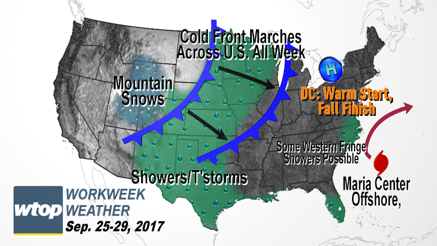
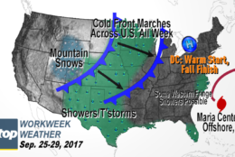
High pressure that has been keeping it dry and unseasonably warm will remain in control of the weather, but some interactions with Hurricane Maria will bring some caveats.
WASHINGTON — High pressure that has been keeping us dry and unseasonably warm (it got to above 90 degrees at Reagan National on Sunday) will remain in control of our weather, but some interactions with Hurricane Maria will bring some caveats.
For one thing, a change in wind direction will pump in even more humidity off the ocean and the bay. However, in that process, the extreme summer-like temperatures will be trimmed somewhat. In terms of comfort level, it may end up like “six of one, half dozen of the other” if it cools down but gets more humid. At any rate, as Maria makes its closest approach to the mid-Atlantic coast, we will certainly see some clouds blowing off the top of the storm system. By midweek there could even be a few showers here at home, but we would just be on the westernmost fringe and aren’t expecting the showers to add up to much.
It looks like the dry spell will continue, even with a strong cold front on the way for the end of the week. This front will kick Maria out to sea for good. But it will also finally bring autumnal weather back to our area. During this stretch of warm weather in the East, it’s been very cool in the western U.S. and Canada, especially in the mountains. Some of that weather is simply spreading east.
The pattern is pretty well established and confidence is pretty high on the details. The only wild cards this week are how much cloud cover we get on Tuesday from Maria (that would have an effect on high temperatures) and if any showers will even produce measurable rainfall. Also, the timing of the cold front for Thursday has some variability: if it’s faster we’ll end up cooler; if it’s slower we’ll be warmer and unstable enough perhaps for a thunderstorm or two.
High pressure that has been keeping us dry and unseasonably warm (getting above 90 degrees at Reagan National on Sunday) will remain in control of our weather, but some interactions with Hurricane Maria will bring some caveats.
(WTOP/Storm Team 4)
WTOP/Storm Team 4
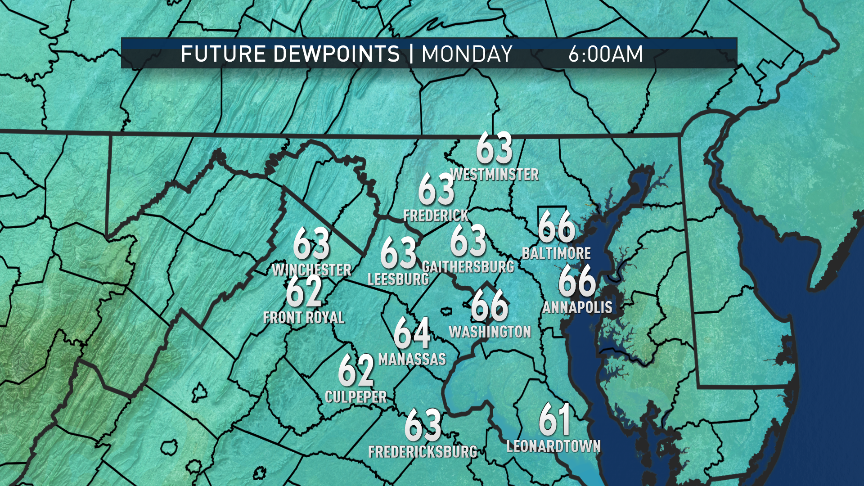
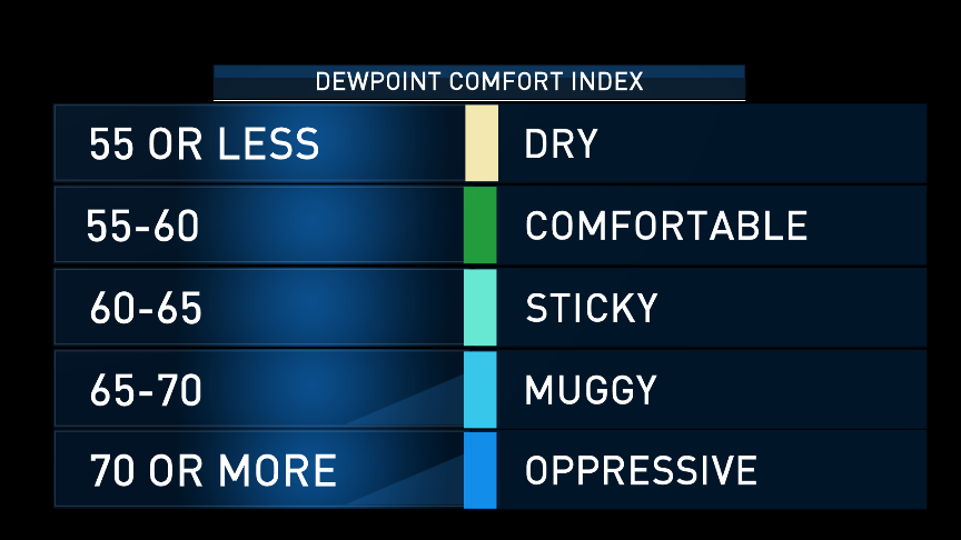
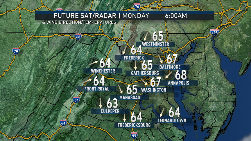
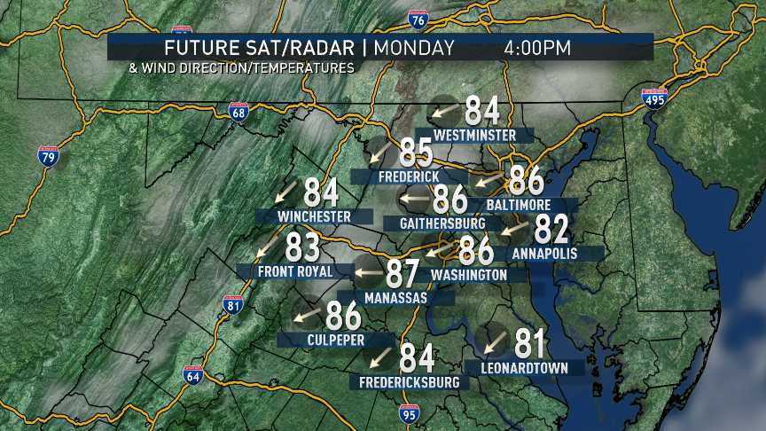
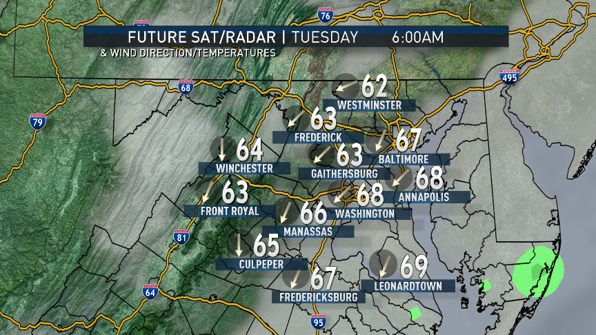
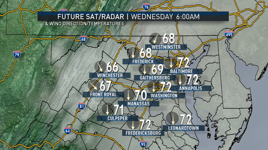
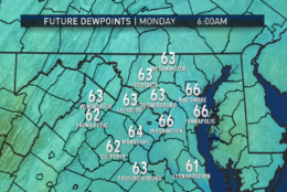
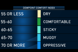
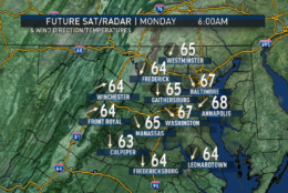
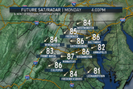
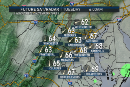
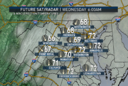
The following images from the RPM computer model output show dew point temperatures climbing through Wednesday morning, as the onshore flow increases between high pressure over New England and the hurricane moving closer to the Carolinas coastline. Dew points in the mid-60s would be considered uncomfortable in the middle of summer, much less the beginning of fall. So getting close to 70 will be an almost tropical, muggy feel.
(Data: The Weather Company. Graphics: Storm Team 4)
Data: The Weather Company. Graphics: Storm Team 4
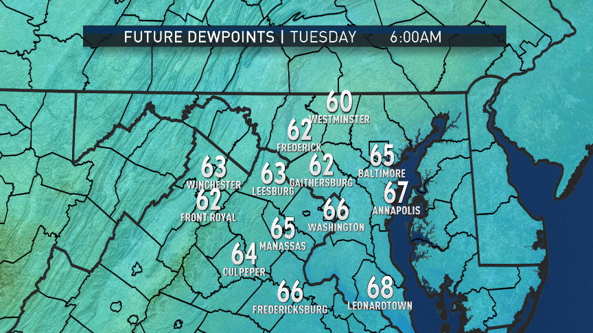
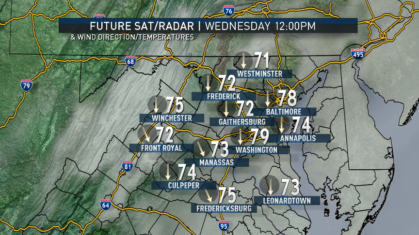
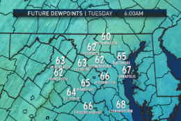
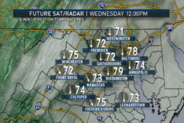
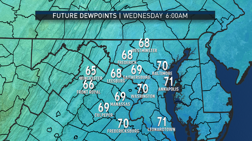
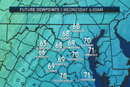
The following images from the RPM computer model output show dew point temperatures climbing through Wednesday morning, as the onshore flow increases between high pressure over New England and the hurricane moving closer to the Carolinas coastline. Dew points in the mid 60s would be considered uncomfortable in the middle of summer, much less the beginning of fall. So getting close to 70 will be an almost tropical, muggy feel.
(Data: The Weather Company. Graphics: Storm Team 4)
Data: The Weather Company. Graphics: Storm Team 4
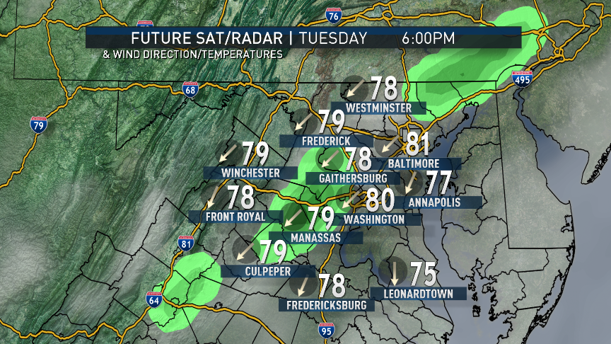
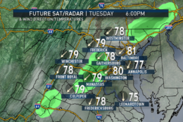
Also from the RPM computer model, we can see the increasing cloud cover as we go through midweek. The model does produce a few light scattered showers and drizzle Tuesday afternoon and evening, right on the fringe of Maria’s circulation. The breeze may pick up a bit, too, Tuesday night into Wednesday. Heavier rains and winds are unlikely to make it farther northwest than the Outer Banks or Hampton Roads. Note the clouds and the easterly winds keeping temperatures from being as close to 90 as we were over the weekend.
(Data: The Weather Company. Graphics: Storm Team 4)
Data: The Weather Company. Graphics: Storm Team 4
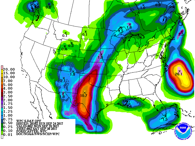
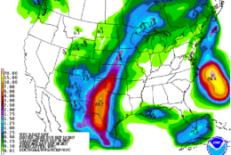
The rainfall forecast for the week from the Weather Prediction Center backs up the thinking that the dry spell here will continue. We haven’t had a soaking rain since Sep. 6, and that was only .55 inches at Reagan National. In this graphic, note the severe weather and excessive rainfall in the South as the cold front marches across the country. The heaviest rain from Maria will stay out to sea. This data is valid through Friday evening.
(Weather Prediction Center, NOAA)
MONDAY:
• A mild and sticky start, some patchy fog in the river valleys
• Lots of sunshine with a hint of haze and high level clouds
• Hot in the afternoon, especially for late September
TUESDAY:
• Clouding over from the southeast to northwest
• Easterly breezes make it more humid
• Slight chance of some drizzle or light showers, mostly east of I-95 and toward the Chesapeake Bay
• Still feeling like summer but not as hot
WEDNESDAY:
• Breezy
• Mostly cloudy
• Warm and very muggy
• A chance of light showers or drizzle, mostly east of I-95
THURSDAY:
• Mix of clouds and sun
• Breezy & warm
• Still humid
• Watching possibility of showers or a thunderstorm
• Lowering humidity later in the day
FRIDAY:
• Mix of clouds and sun
• Breezy, more seasonable, and more comfortable
Editor’s Note: The WTOP Workweek Weather Blog is intended as an in-depth yet plain language summary of the business week’s weather potential in the D.C. area along with an explanation of the contingencies and uncertainties that exist at the time of publication. For the latest actual Storm Team 4 forecast, check out the link on the main WTOP Weather Page.