Workweek weather: Big temperature swings, plus more rain

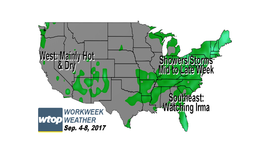
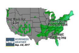
WASHINGTON — The new workweek, shortened by Labor Day for many, will be a fairly active week weather-wise, as the D.C. area will have some ups and downs in temperature extremes and another dose of soaking rainfall. 

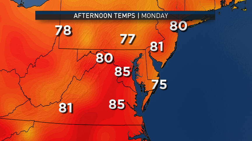
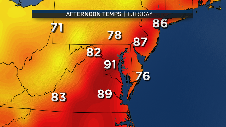
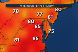
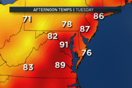
Monday and Tuesday both come with reminders that Labor Day is only the unofficial end of summer, as temperatures will be back into the upper 80s, if not 90s, and the humidity will start climbing again on Tuesday. This will all be due to high pressure cutting to the south, putting the region in a broad southwesterly wind flow.

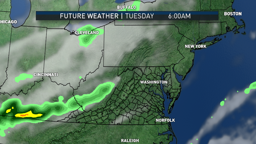
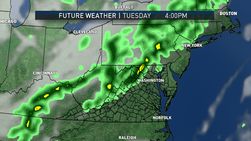
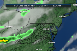
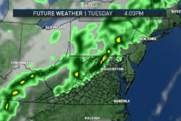
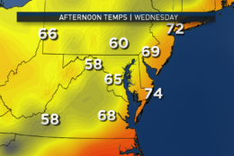
Temperatures will be maximized on Tuesday afternoon, just ahead of a strong cold front approaching from central Canada. Showers and storms will accompany the front, and temperatures will start dropping almost as soon as it starts raining.

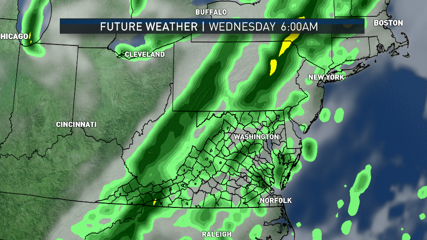
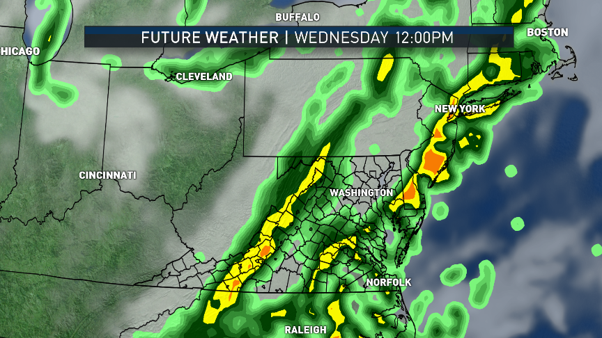
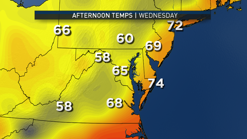
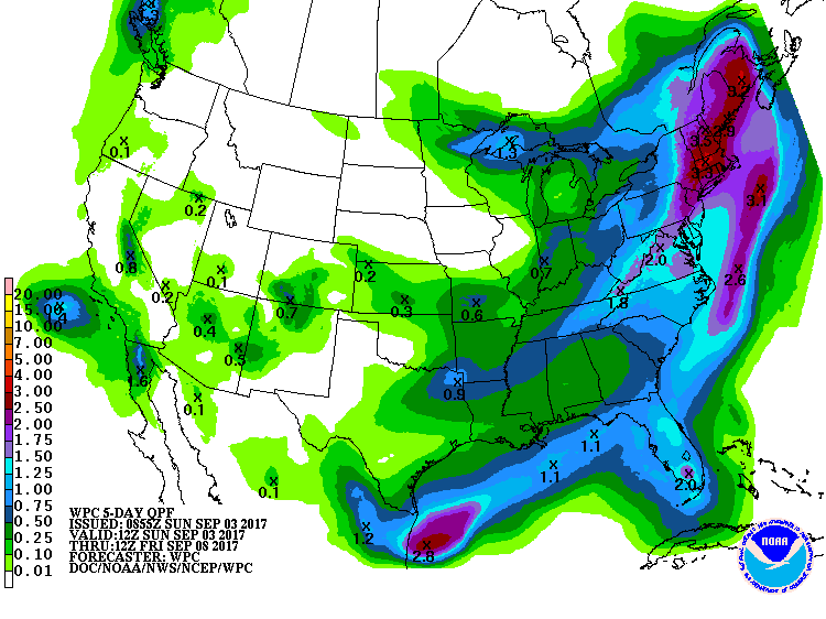
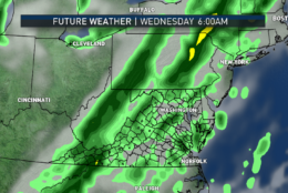
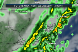
The front looks like it will slow down and hang up just to the east Wednesday. That would put us not just on the cold side of the front, but northerly winds added to more soaking rain will keep Wednesday on the cool side, perhaps a lot like it was on Saturday when the remnants of Harvey were here.

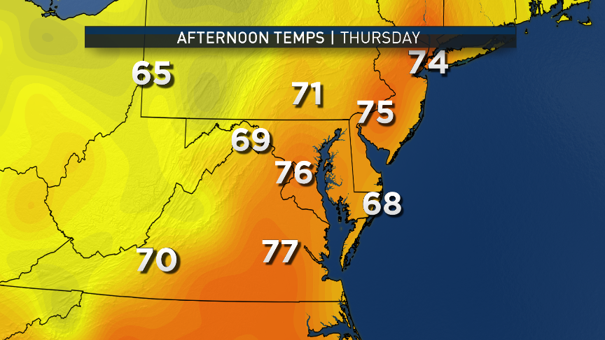
It looks like most of the area will pick up close to an inch of rainfall in the Wednesday-Thursday time frame, adding to the surplus for the year. (It’s almost hard to believe the region was in a drought most of the year.) The Washington Nationals return to D.C. for a series with the Phillies starting Thursday. If the front slows down even more, the Thursday game may have some issues.

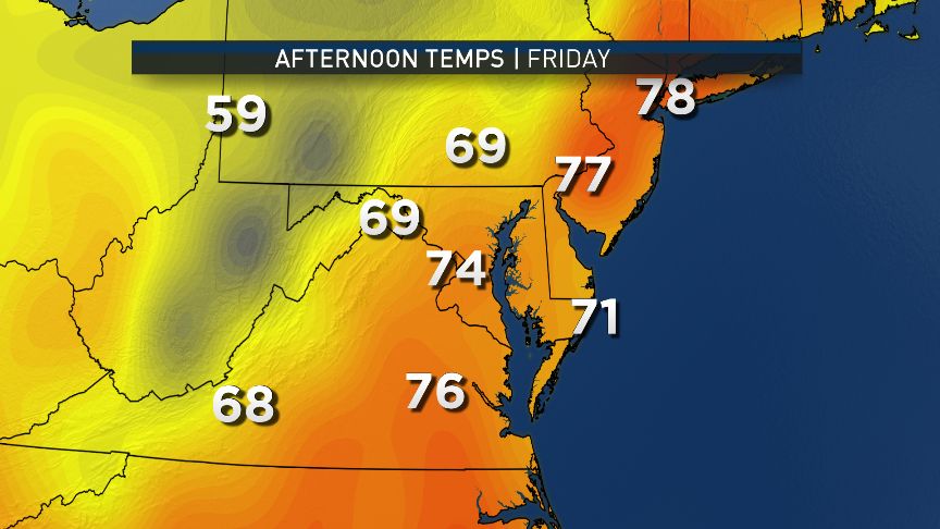
High pressure will finally push the front out to sea for the end of the week and provide us with cooler, dry northwesterly winds. Temperatures will be higher than the cool washout on Wednesday, but they will be below average. Average high temperatures this time of year for the area are in the low 80s.

WTOP and Storm Team 4 will be tracking the progress of Hurricane Irma in the days ahead. If the D.C. area were to eventually get any direct effects from the storm, it would not be until the beginning of next week. It is the same front moving through here midweek which will eventually have an effect on Irma’s path. Whether the front will cause enough of a turn to protect the eastern seaboard of the U.S. is the huge wild card at this point.

This week, temperatures will see some ups and downs, and there will be a dose of soaking rainfall. (WTOP/Storm Team 4)
This series of images is from the RPM computer model starting Tuesday, showing the progress of the cold front with rain arriving late and lasting through Wednesday, the extent of this particular run. (Data: The Weather Company. Graphics: Storm Team 4)
The American global model, the GFS, shows the potential for the big temperature changes this week thanks to the cold front and the rain. Monday and Tuesday are summery; Wednesday during the likely washout will not be summery. If the front ends up much slower, then the model is too warm for Thursday. Even though Friday will be a dry day, northwesterly winds will keep it feeling like fall. (Data: Weather Prediction Center, NOAA. Graphics: Storm Team 4)
As mentioned, the rain this week could be soaking. Projections from the National Weather Service are in line with most computer models bringing our area an inch of rainfall if not a little more. This graphic is valid from 8 a.m. Monday through 8 a.m. Friday. Our amounts would occur Wednesday and Thursday. (Weather Prediction Center, NOAA)
As mentioned, the rain this week could be soaking. Projections from the National Weather Service are in line with most computer models bringing the D.C. area an inch of rainfall, if not a little more. This graphic is valid from 8 a.m. Monday through 8 a.m. Friday. The region’s amounts would occur Wednesday and Thursday. (Weather Prediction Center, NOAA)
(1/11)
This week, temperatures will see some ups and downs, and there will be a dose of soaking rainfall. (WTOP/Storm Team 4)
This series of images is from the RPM computer model starting Tuesday, showing the progress of the cold front with rain arriving late and lasting through Wednesday, the extent of this particular run. (Data: The Weather Company. Graphics: Storm Team 4)
The American global model, the GFS, shows the potential for the big temperature changes this week thanks to the cold front and the rain. Monday and Tuesday are summery; Wednesday during the likely washout will not be summery. If the front ends up much slower, then the model is too warm for Thursday. Even though Friday will be a dry day, northwesterly winds will keep it feeling like fall. (Data: Weather Prediction Center, NOAA. Graphics: Storm Team 4)
As mentioned, the rain this week could be soaking. Projections from the National Weather Service are in line with most computer models bringing our area an inch of rainfall if not a little more. This graphic is valid from 8 a.m. Monday through 8 a.m. Friday. Our amounts would occur Wednesday and Thursday. (Weather Prediction Center, NOAA)

Daily weather highlights

MONDAY
• Cool start
• Borderline mostly-to-partly-sunny conditions
• Warmer than over the weekend, feeling like summer again

TUESDAY
• Becoming muggy during the day
• Temperatures above average with some spots near 90, especially urban areas
• Increasing clouds late in the day
• Slight chance of showers or a thunderstorm
• Steadier rain holding off until overnight

WEDNESDAY
• Cloudy, damp and cooler
• Temperatures well below average
• Periods of rain, moderate at times
• Chance of thunder
• Temperatures could vary greatly across the area based on meandering front or lesser amounts of rain
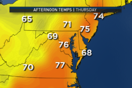
THURSDAY
• Likely still raining in the morning
• Steady rain tapering to showers or ending completely close to evening
• Temperatures still cool for this time of year
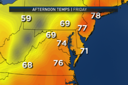
FRIDAY
• Mix of clouds and sun; “changeable” skies
• Breezy and still cool for September, but milder than midweek


Editor’s Note: The WTOP Workweek Weather Blog is intended as an in-depth yet plain language summary of the business week’s weather potential in the D.C. area along with an explanation of the contingencies and uncertainties that exist at the time of publication. For the latest actual Storm Team 4 forecast, check out the main WTOP Weather Page.

Federal News Network Logo
Log in to your WTOP account for notifications and alerts customized for you.

Sign up