Monday could be muggy with warmer temperatures coming later in the week. Here's what you need to know about the workweek weather.
WASHINGTON — Sunday’s quiet, comfortable weather was certainly welcomed by most.
It was all courtesy of a ridge of high pressure that is now heading out to sea, and just like that, humidity started climbing back Sunday night on southeasterly winds and the humidity will keep climbing, making for a real tropical feel to the air in the coming days.
Temperatures at first won’t be too hot, but that may change by the weekend. Along with the increased humidity, there will be chances for thunderstorms.
Clouds and thunderstorms will likely block enough sun that temperatures stay close to seasonable averages, especially the first half of the week.
After Wednesday, however, more of a straight southerly or southwesterly flow will potentially get us back into the low 90s, and the humidity will make it apparently even hotter.
The mention of hot weather for the end of the week is a bit of a change from previous thinking as it is just now starting to show up in the longer range computer models.
The large scale pattern is somewhat complex, complicating some of the computer models. There is therefore a lot of uncertainty after Wednesday and the specifics in the actual forecast will be evolving during the week.
Either way, it is not anticipated that any weather this week will be cooler than our averages which are in the mid 80s.
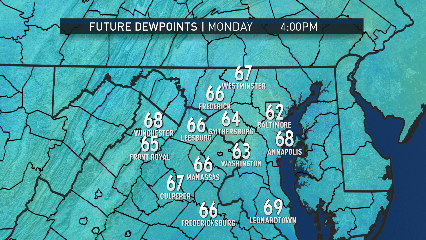
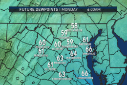
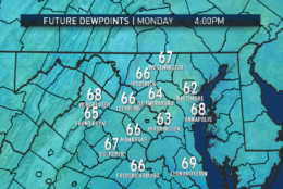
These snapshots from the RPM computer model show the dew points climbing on Monday through Tuesday, followed by a potential break in the humidity temporarily Tuesday night into Wednesday. Remember, the higher the dew point, the higher the amount of moisture in the air. When dew points start getting into the 70s, it starts to feel uncomfortable to most. .
(Data: The Weather Company. Graphics: Storm Team 4)
Data: The Weather Company. Graphics: Storm Team 4
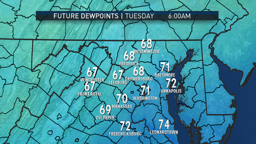
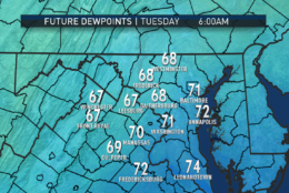
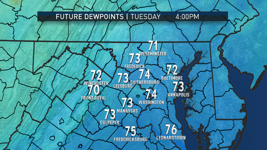
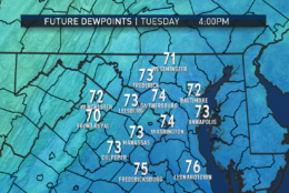
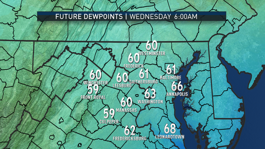
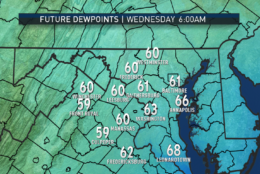
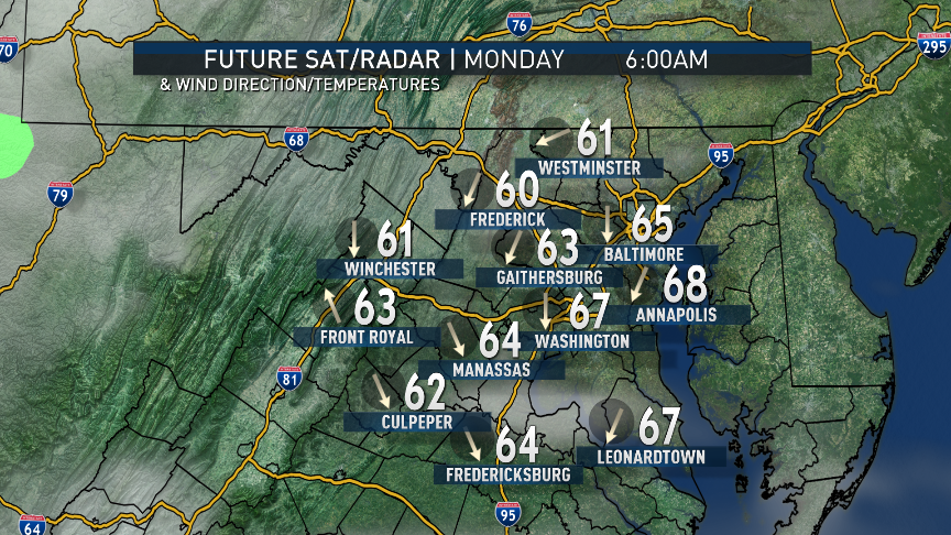
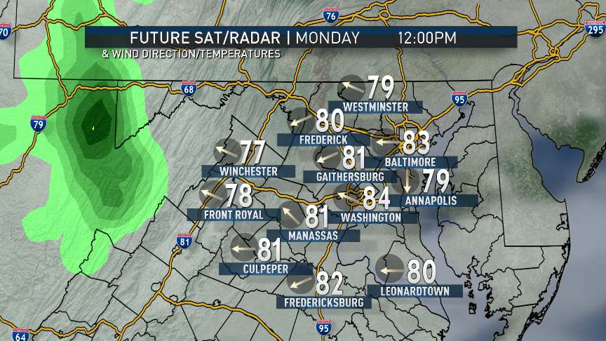
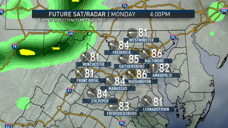
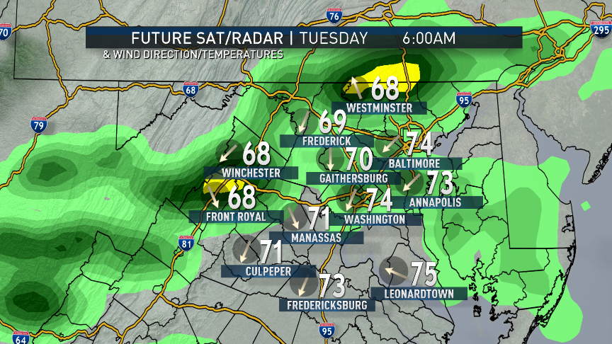
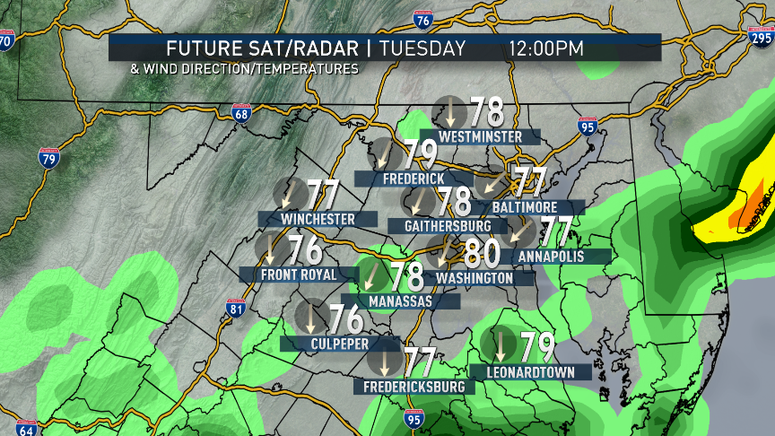
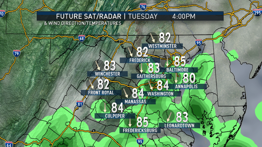
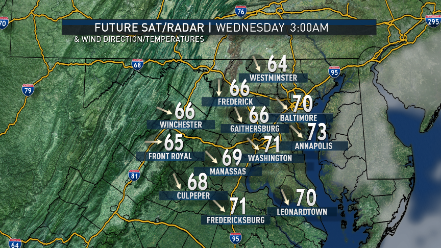
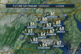
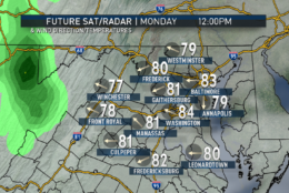
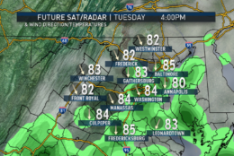
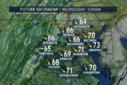
These images are the simulated satellite and radar with a plot of surface temperatures and wind direction from the same run of the RPM. Note the southeasterly winds Monday pumping in the increased humidity off the Atlantic and Chesapeake. The “pooling” of moisture being forced up the mountains will start the first round of showers and thunderstorms. After some more scattered storms on Tuesday, a slight wind direction change should bring in some drier air temporarily for early Wednesday. Also notice those afternoon temperatures are too bad. The real heat may be coming back between Wednesday and Friday.
(Data: The Weather Company. Graphics: Storm Team 4)
Data: The Weather Company. Graphics: Storm Team 4
These images are the simulated satellite and radar with a plot of surface temperatures and wind direction from the same run of the RPM. Note the southeasterly winds Monday pumping in the increased humidity off the Atlantic and Chesapeake. The “pooling” of moisture being forced up the mountains will start the first round of showers and thunderstorms. After some more scattered storms on Tuesday, a slight wind direction change should bring in some drier air temporarily for early Wednesday. Also notice those afternoon temperatures are too bad. The real heat may be coming back between Wednesday and Friday.
(Data: The Weather Company. Graphics: Storm Team 4)
Scattered thunderstorms developing near the mountains and near the Bay
TUESDAY:
Mostly cloudy with scattered showers and thunderstorms through midday
Warm and very muggy
Humidity dropping a bit late in the day
WEDNESDAY:
Partly sunny and hazy
Very warm and with increasing humidity
Getting close to 90 again
THURSDAY and FRIDAY:
Partly sunny
Hazy, hot, and humid
Isolated late-day thunderstorms
Highs in the low 90s possible with Heat Index in upper 90s
Editor’s Note: The WTOP Workweek Weather Blog is intended as an in-depth yet plain language summary of the business week’s weather potential in the D.C. area along with an explanation of the contingencies and uncertainties that exist at the time of publication. For the latest actual Storm Team 4 forecast, check out the link on the main WTOP Weather Page.