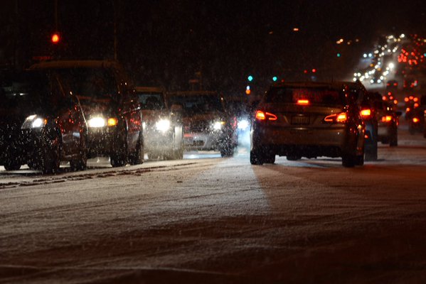

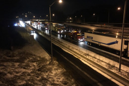
@WTOP we've moved about 2/4 mile in 4 hours!! Check the ice on the road!! pic.twitter.com/8oFC8sUzS9
— LuminoUSCowboy (@LuminoUSCowboy) January 21, 2016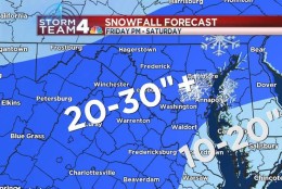

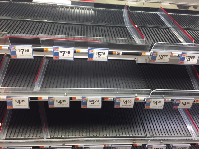
WASHINGTON — A massive blizzard threatening the D.C. area has shut down several schools and the transit system, and threatens to paralyze the region for several days afterward. The storm is projected to pack high winds and flooding, and as much as 30 inches of snow, according to NBC Storm Team 4’s latest forecast.
D.C., Maryland and Virginia have declared states of emergency.
- D.C. Mayor Muriel Bowser declared a snow emergency will go in effect at 9:30 a.m. Friday.
- Virginia Gov. Terry McAuliffe put a state of emergency in effect Thursday morning.
- Maryland Gov. Larry Hogan declared a state of emergency.
The Office of Personnel Management (OPM) has announced the federal government offices will close at noon on Friday. Employees have the option for unscheduled leave or telework. Those who do report to their worksites are advised to leave 4 hours earlier than their normal departure time, but no later than noon — which is when federal offices in the D.C. area will close.
Read additional details from OPM by clicking here.
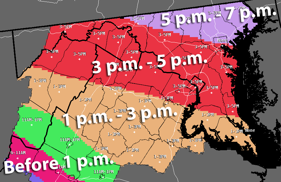
The National Weather Service has issued a Blizzard Warning for the immediate D.C. area that is in effect starting Friday afternoon through 6 a.m. Sunday.
Quick Links:
WEATHER:
A Blizzard Warning goes into effect Friday afternoon and lasts through Sunday morning. More than a foot of snow is expected.
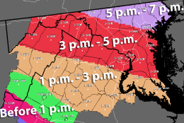
Here’s a look at the timeline for what’s expected.
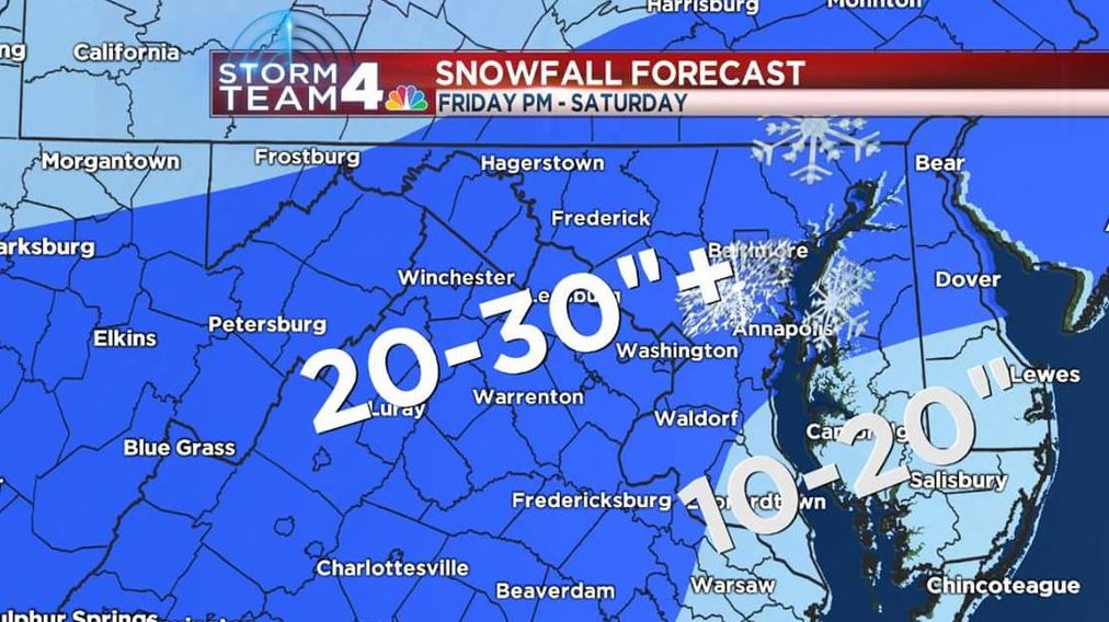
Snow will develop over our southern and western suburbs by 1 pm Friday. This includes Warrenton and Fredericksburg. Snow will rapidly move northeastward, with all of the metro area experiencing snow by 4 p.m. Four to 8 inches of snow are possible by 7 p.m., 8-12 inches by 11 p.m. and 12-18 inches are possible by sunrise Saturday morning.
NBC Storm Team 4 Chief Meteorologist Doug Kammerer says total storm accumulations will average 20-30 inches.
“Earlier, I had 18 to 24 [inches]. I’m now going 20 to 30 inches of snow, plus,” Kammerer said on NBC Washington Thursday night. “This is a monster of a storm.”
Travel will rapidly become difficult or impossible Friday evening, with most roads totally impassable Saturday.
Along with the snow winds gusting as high as 50 mph will cause considerable blowing and drifiting of snow, reducing visibilities to near zero at times. Power outages will be widespread, and the heavy snow and high winds may keep crews from doing work until Sunday. Expect major disruptions of travel to continue Sunday, Monday and possibly Tuesday.
Yet despite the forecast, weathermen don’t always get it right.
The Blizzard Warning goes into effect in the following communities:
3 p.m. Friday to 6 a.m. Sunday
- D.C.
- VIRGINIA: Arlington County, Fairfax County, Loudoun County, City of Falls Church, City of Alexandria
- MARYLAND: Prince George’s County, Montgomery County, Anne Arundel County, Howard County
1 p.m. Friday to 6 a.m. Sunday
- VIRGINIA: Prince William County, Stafford County, Spotsylvania County, Fauquier County, Culpeper County, City of Manassas, City of Manassas Park
- MARYLAND: Calvert County, Charles County, St. Mary’s County
6 p.m. Friday to 6 a.m. Sunday
- MARYLAND: Carroll County, Frederick County, Baltimore County, Harford County
Get the full forecast on the WTOP.com weather page.
COMMUTING/TRAVEL:
Metrorail
- On Friday, Metrorail will open at 5 a.m. with service both above and below ground until 11 p.m.
- At 11 p.m. Friday, the Metrorail system will close and will remain closed all day Saturday and Sunday.
- Metro will protect hundreds of railcars by storing them in the tunnels during the storm.
- Information regarding the restoration of service will be provided via broadcast media outlets, social media, Metro’s website, and through email and text messages.
Metrobus
- Bus service will begin the day Friday on a “severe” snow weather plan. Under the severe plan, buses operate only on major corridors. For details on which routes operate under the severe plan, go here.
- Operating on a “severe” service plan helps to ensure that customers and employees are not stranded once the storm begins.
- Bus service will be suspended systemwide at 5 p.m. Friday as the storm moves into the region. The last buses will depart their origin points at 5 p.m. and operate to the end of the route before ending service.
- Bus service will remain suspended on Saturday and Sunday.
MetroAccess
- MetroAccess paratransit service for customers with disabilities will be suspended Friday after 6 p.m.
- To prevent customers from being stranded, MetroAccess will not begin any new outbound trips after 1 p.m.
- MetroAccess service will remain suspended on Saturday and Sunday.
How to stay informed
- Visit Metro’s website
- Sign up for MetroAlerts to receive email/text updates
- Call 202-637-7000 for recorded updates
- Follow Metro on Twitter: @metrorailinfo @metrobusinfo
Metro’s customer call center will close at 5 p.m. Friday at the conclusion of Metrobus service. The call center is expected to reopen at noon Sunday (weather and road conditions permitting).
Metro essential personnel are expected to report to work as scheduled. Non-essential employees will be dismissed at noon Friday.
“This is not a storm that anyone should take lightly, and I would urge all residents to plan to get to a safe place before the storm arrives Friday afternoon,” said Paul Wiedefeld, Metro’s general manager and CEO. “The actions we are taking today are all in the interest of our customers’ and employees’ safety, and will help us return to service once the storm passes and the snow is cleared.”
- Amtrak will operate on a modified schedule in the Northeast. Passengers holding reservations are strongly encouraged to keep a close eye on conditions and make any necessary changes in advance of their scheduled departure using Amtrak.com or our mobile apps to check their train status.
- Acela Express, Northeast Regional and other services between locations in Virginia and Boston, as well as Keystone Service between Harrisburg, Pennsylvania and New York, will operate throughout the weekend, but will have modified schedules, with fewer trains.
Most Northeast Corridor service between D.C. and Boston will operate as scheduled on Friday, Jan. 22. Passengers who have reservations on affected services are being contacted and accommodated on other trains with similar departure times or offered alternate travel dates.
Several Amtrak national services to and from the East Coast are canceled or truncated, including:
- Auto Train (Lorton, Va. – Sanford, Fla.), Trains 52 & 53, will not operate Jan. 22 and 23
- Capitol Limited (Washington, D.C. – Chicago), Train 30, will operate only between Chicago and Pittsburgh for originations of Jan. 22 and 23
- Palmetto (New York – Savannah, Ga.) Train 89 will not operate and Train 90 will operate between D.C. and New York only on Jan. 23.
As of 10 p.m. tonight, VRE plans to operate an “S” schedule on Friday. Only trains marked with an “S” on the schedule will operate.
MARC will operate on an “S” schedule on Friday, with the following modifications:
- Brunswick Line: Train 873 (3:30 p.m. departure from Union Station) will operate west of Brunswick to Harpers Ferry, Duffields and Martinsburg. Train 877 (4:55 p.m. departure) will terminate at Brunswick.
- Camden Line: There will be a special early Camden Line departure from Union Station at 2:15 p.m. This train will make all stops to Camden Yards. In order to operate this special departure, Train 852 (4:43 p.m. departure from Union Station) will not operate. Camden Line trains will depart Union Station on Friday at 2:15 p.m., 4:13 p.m. and 5:53 p.m.
- Penn Line: Trains will operate on the “S” schedule as planned and will operate with additional railcars. Passengers are reminded that under the “S” schedule Trains 418 and 422 (11:20 and 1:20 departures from Union Station) will not operate.
Click here for more information and details from MARC.
Car-sharing service, car2go, is suspending service starting at 9 p.m. Thursday.
The D.C. Taxicab Commission has enacted a Snow Emergency Fare that will go into effect 9:30 a.m. Friday. The fare authorizes taxicabs to add a flat fee of $15 to the metered charge.
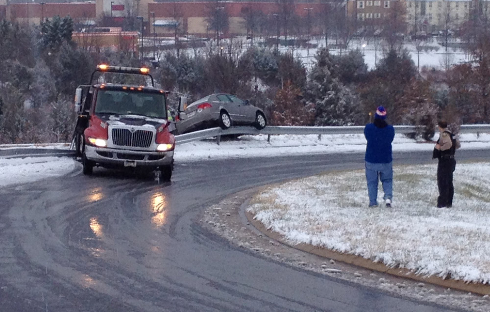
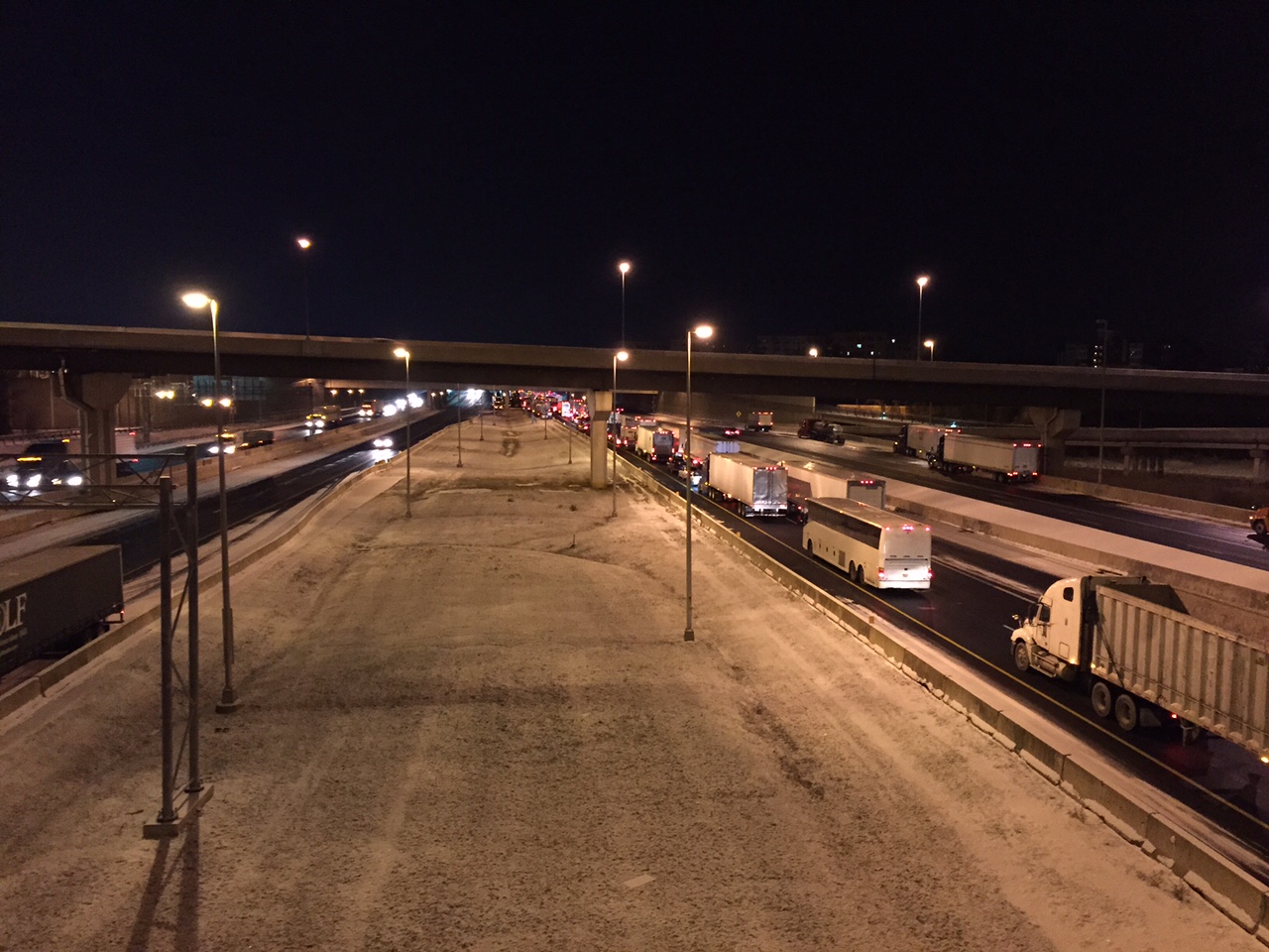
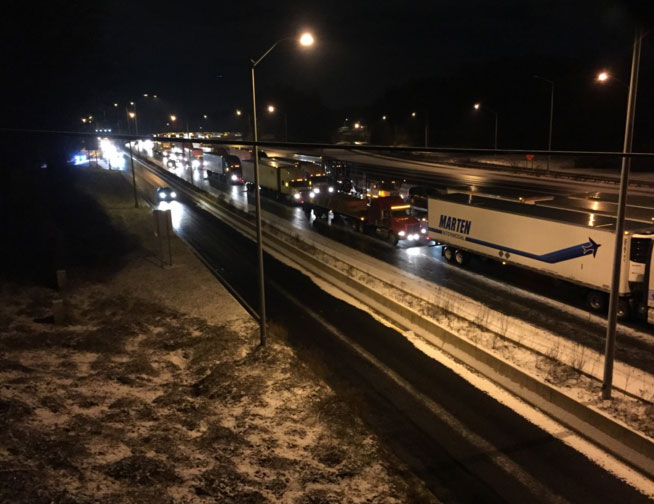
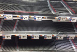
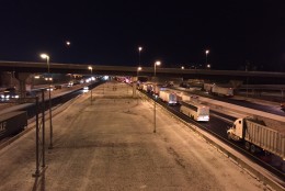
Many people around the region are still recovering after Wednesday’s painful commute where drivers endured hourslong delays getting home. Serious problems arose following a dusting of snow that turned highways into ice rinks, leaving some people stranded for hours. Some transportation agencies apologized for not treating the roads quickly enough.
Read commuters’ comments, see their photos and listen to their pain over the “commute from hell.”
Get the latest traffic updates on the WTOP traffic page, by following @WTOPTraffic on Twitter and by listening to 103.5 FM on-air or online.
CLOSINGS AND DELAYS
Several school districts around the region have canceled classes and activities for Friday as well as activities scheduled through the weekend.
Get the full list of closings and delays on WTOP.com.
POWER OUTAGES
Utility companies are warning customers to brace for outages — some of which could last for multiple days.
Pepco spokesman Bob Hainey says the utility is planning for the worst.
Both Pepco and Baltimore Gas and Electric are calling in extra crews and setting up storm operation centers.
Justin Mulcahey with BGE reminds customers to report any loss of power and prepare an emergency plan together.
On its website, Dominion Virginia Power advises customers to charge mobile devices, so you can easy check the status of outages.
The Northern Virginia Electric Cooperative says they’re preparing for the snow and possible outages caused by snow-laden trees and branches resting on power lines. They’re preparing their vehicles for snowy road conditions and going to “all hands on deck” scheduling.
If you need the phone number for your power company, text the word POWER to 91035 and WTOP will text it back to you.
LISTEN LIVE:
Listen live on WTOP.com, on the WTOP app or tune in to 103.5 FM.
Follow along with the latest traffic updates via our live blog below: