 Maybe you, too, have driven in the leftmost lane of a tunnel when you realize, 30 seconds after the GPS signal drops, that you need to exit via the rightmost lane.
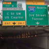
Like plenty of cities, the District has gaps where navigation apps like Google Maps, Apple Maps and Waze drop the connection in tunnels underwater or underground. As a result, drivers may slow down or even pause in the middle of traffic, creating unsafe conditions, or they go the wrong direction until their apps resync and they can turn around.
To address this issue, D.C.’s Department of Transportation is partnering with Waze, an Alphabet Inc. (NASDAQ: GOOGL) subsidiary that provides satellite navigation software, to incorporate new technology in three tunnels near the National Mall: Third Street, Ninth Street and 12th Street NW.
“This technology will allow for more seamless navigation, particularly for visitors and residents who are less familiar with our tunnel lane configuration and exit locations,” Everett Lott,…
Read the full story from the Washington Business Journal.