A new array of flood sensors will help alert residents in Montgomery County, Maryland, when water levels are rising.
The solar-powered flood sensors are active in 22 locations around Montgomery County, with another 13 sites soon to come.
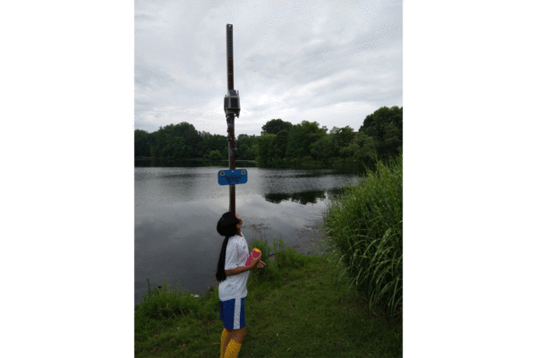
The sensors work by use of a tethered node placed underwater and anchored to the bottom of the body of water. The node measures water pressure, which increases as water rises. The sensor then calculates the depth of the water and remotely reports that information to a central system every five minutes.
Each sensor location has a predetermined threshold for water depth. When water levels approach that limit, the sensor sends out an alert so a crew can investigate.
On Friday, one of these sensors was installed at Rock Creek Woods Apartments in Rockville where a 19-year-old died after an apartment building flooded last September.
The sensors were provided by the U.S. Department of Homeland Security Science and Technology Directorate.
The Montgomery County Department of Environmental Protection led the effort to get the sensors and the County’s Office of Emergency Management and Homeland Security worked on a Cooperative Research and Development Agreement with DHS and Intellisense Systems, the company that makes the devices.
“This partnership between DHS and the County is critical to our efforts in warning Montgomery County residents about dangerous and life-threatening floods,” said Montgomery County Executive Marc Elrich. “Just a few weeks ago, heavy rain caused flash flooding that left several drivers stranded in their vehicles in Bethesda… The County is no stranger to this kind of weather event, but now that we have these flood sensors, we can notify residents sooner of where flooding is happening so they can avoid danger.”
Sign up for emergency text alerts on the Montgomery County Office of Emergency Management and Homeland Security website.
The locations of the currently installed sensors are:
- University Boulevard pond
- Wheaton — downstream of dam
- Olney Oaks Regional
- Wheaton Pond dam
- Lake Hallowell
- Vineyard
- Christie Estates
- Great Seneca Creek at Brink Road
- Rattlewood Golf Course dam
- 8900 block of Gue Road
- 11200 block of Game Preserve Road
- New Cut Road at Little Seneca Creek
- Environ HOA
- Gunners Lake dam
- Lake Whetstone
- Pueblo
- Sligo Creek at Knowles Avenue
- Hawlings River at Brighton Dam Road
- Reddy Branch at Brookeville Road
- Pine Lake dam
- Hawlings River at Zion Road
- Burnt Mills dam