This article was republished with permission from WTOP’s news partners at Maryland Matters. Read the story at Maryland Matters.
This content was republished with permission from WTOP’s news partners at Maryland Matters. Sign up for Maryland Matters’ free email subscription today.
On the first day of a special session, the Maryland General Assembly took steps to advance a congressional redistricting proposal that is likely to replicate the current split in the state’s U.S. House delegation — seven Democrats and one Republican.
After more than two hours of public testimony, the House Rules Committee voted 18-6 on Monday in support of House Bill 1, setting the stage for further action later in the week.
HB1 was crafted by the Legislative Redistricting Advisory Commission (LRAC), a panel made up of House and Senate leaders — four Democrats, two Republicans and a non-voting chairman, a former top staffer.
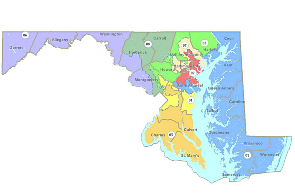
In its current form, the measure would make a series of noticeable changes to the state’s current — and controversial — congressional map. But like that map, in use since 2012 and the subject of much litigation, several districts wander the state in circuitous fashion.
Republicans and gerrymandering foes have criticized the proposal, saying it still comes off looking like a map drafted by politicians in search of electoral advantage.
Undaunted, House Majority Leader Eric G. Luedtke (D-Montgomery), a member of the LRAC, told his colleagues the proposal represents an improvement over the current map.
“This map is more compact and contiguous and continues our decades-long commitment to diverse representation…,” he said. “Six of the eight districts under this map are more competitive than they are under the current map.”
Luedtke also said HB1 (and the companion Senate Bill 1) “keeps significant majorities” of voters in their current districts.
Karl Aro, former head of the Department of Legislative Services and the chair of the LRAC, said voters “don’t necessarily like current lines, but they do like their current representation.”
The full House could act on the measure as early as Tuesday.
Monday’s vote in House Rules followed a joint hearing with the Senate Reapportionment and Redistricting Committee. The lopsided nature of the vote reinforced the strong hand that Democrats hold in the politically charged process of redrawing the state’s congressional districts.
Republicans — including Gov. Lawrence J. Hogan Jr. — have acknowledged for weeks that Democrats have the numbers to work their will at this stage in the process. If the map preferred by legislative leaders and their allies in Congress is to be stopped, it is likely to be in the courts, GOP officials have said.
A map crafted by a second panel, the Hogan-created Maryland Citizens Redistricting Commission (MCRC), differed greatly from the legislature’s.
The nine-member MCRC consisted of an equal number of Democrats, Republicans and independents and adopted a start-from-scratch approach. Their proposal, House Bill 2/Senate Bill 2, contains districts that are far more compact and intuitive.
Stanford University law professor Nathaniel Persily, a nationally-recognized redistricting expert who assisted the MCRC, praised the panel for the way it went about its business — and the map it ultimately produced.
At Monday’s meeting he said the panel’s maps achieved Voting Rights Act compliance “without having to sort of draw contorted districts” and minimizing county splits.
“It is refreshing to see this kind of bipartisan and independent work being done in the public interest,” he said. “It really is a model for how this work could be done in the future.”
House Bill 2 did not receive a vote on Monday. Members of the Senate Republican Caucus told reporters that they intend to introduce the MCRC alternative as a substitute when the legislature’s preferred bill reaches the Senate floor later this week.
In an interview, Senate President Bill Ferguson (D-Baltimore City), who served on the LRAC, appeared unmoved by complaints that the commission’s work product isn’t “pretty.”
“I don’t think that pretty is a standard in any statutory or constitutional authority,” he said. “What it is about is ensuring that communities of interest are protected and that Marylanders are accurately reflected in the maps that are passed.”
Many of the people who testified on Monday said they prefer the tighter, cleaner approach taken by the MCRC.
“The citizens commission did a fantastic job defining a fair map for everyone,” said Deb Rey, a former Republican state delegate from St. Mary’s County. “It’s bipartisan. They quickly responded to citizen input. The districts are compact, keeping all but five counties whole and in one district. And each district total is within one person. I am amazed by that.”
District 1’s Bay Watch
The most high-profile change the LRAC map makes is the inclusion of parts of Anne Arundel County in the 1st District, the seat currently held by conservative Rep. Andrew P. Harris (R).
The LRAC’s 1st District has a 51% edge for Democrats and has the potential to make Harris’s re-election bid more competitive. A Trump-aligned conservative, he is the lone Republican in the Maryland congressional delegation.
A handful of 1st District residents told lawmakers they should include even more of Anne Arundel County in the 1st Congressional District, to create a true Bay-centered district.
“The eastern shore has a lot more in common with Annapolis… than some of those northern areas that are close to Pennsylvania,” said Louise Miller, a Chestertown resident, a reference to the district’s current lines.
She said she regularly visits Annapolis and noted that many Eastern Shore residents commute there.
Luedtke insisted that the LRAC proposal has a lot going for it:
- Western Maryland’s 6th District, which he dubbed a “Potomac district,” “would pull in more of Frederick County while uniting communities along the river.
- Anne Arundel and Baltimore Counties would be split into three ways, instead of the current four.
- The lines in Baltimore City “are significantly more functional.”
- Fast-growing Howard County “becomes the center of a newly-drawn 3rd District” and Columbia is united into a single district.
- Prince George’s County dominates two districts.
“County lines drawn by colonial surveyors 300 years ago simply aren’t an accurate reflection of how people live their lives in modern-day Maryland,” Luedtke said.