Listen to WTOP online and on the radio at 103.5 FM or 107.7 FM for the latest traffic and weather conditions.
This video is no longer available.
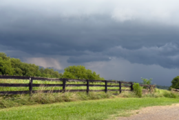
Storms packing heavy rain brought flash flooding to parts of the D.C. region Thursday, including parts of Montgomery County, Maryland, where floodwaters inundated some roadways and led to water rescues.
A strong cold front moved in overnight, setting the stage for more active weather Thursday.
Storms began pounding parts of the region with heavy rain around 2 p.m., prompting severe thunderstorm and flash flood warnings from the National Weather Service.
Ahead of the storms’ arrival, the weather service had issued a flood watch for Thursday afternoon and a severe thunderstorm watch for most of the D.C. region. Both were canceled just before 7 p.m.
By 4:30 p.m., at least 3 inches of rain had fallen in parts of the D.C. region, the weather service said. Around that time, WTOP Meteorologist Mike Stinneford said a “serious flood situation” was unfolding in the Potomac, Maryland, area.
“Shortly before 4 o’clock, it appears significant rain came through the lower part of Montgomery County, which resulted in a number of water rescues. We had some flash flooding. At this particular moment in time, we’ve had six separate incidents that were dispatched in the lower Rockville, Potomac, Bethesda area,” Assistant Chief of Montgomery County Fire and Rescue Daniel Ogren told WTOP around 5:15 p.m.
“I would guess that at this point it’s somewhere between 10 to 12 cars we think were in floodwaters at one point or another,” Ogren added.
He said he’s not aware of any injuries as a result of those incidents.
According to WTOP Traffic reporter Dave Dildine, high standing water was submerging the left lanes of the Capital Beltway Inner Loop near River Road and the right lanes of southbound Interstate 270 at the lane divide.
In Potomac, the area near Counselman and River roads was shut down due to 12-18 inches of water on the roadway, according to Montgomery County Emergency Management. Burke Lake Road in Fairfax County, Virginia, was also reportedly closed in several places.
Showers & strong to severe thunderstorms this afternoon & evening, primarily 1pm and 9pm. The metro areas of Baltimore, MD and The District of Columbia will be the focus for possible Flash Flooding. Flood Watch in effect northern Shenandoah Valley east to Chesapeake Bay. pic.twitter.com/ezgTY7lUbb
— NWS Baltimore-Washington (@NWS_BaltWash) July 31, 2025
Stinneford said there was even a possibility of a tornado threat around the Interstate 95 corridor during the late afternoon hours.


“There is a risk of one or two tornadoes with this line coming into the immediate metro area,” Stinneford reported around 2:15 p.m.
Outside of any wet weather, Thursday brought some reprieve after a four-day long heat wave. The Code Orange air quality alert for Wednesday disappeared, coming back to a Code Green.
Looking ahead
“Some of the best weather of the summer is coming, starting this weekend,” 7News First Alert Chief Meteorologist Veronica Johnson said.
On Friday, lingering showers are likely as the front remains nearby just to the south. With the passage of the front and clouds, temperatures will be in the 70s with only areas inside and close to D.C. reaching the lower 80s. Those at higher elevations will top out in the upper 60s.
“In the 70s and delightful this weekend,” Johnson said.
Saturday will be warm and mostly sunny with temperatures in the low to mid-80s. Clouds will pick up in the afternoon, cooling down into the mid-60s by nightfall.
Sunday will be more of the same — just with less humidity and light winds.
- Listen to WTOP online and on the radio at 103.5 FM or 107.7 FM.
- Current traffic conditions
- Weather forecast
- Closings and Delays
- Sign up for WTOP email alerts
- Get custom alerts with the WTOP app for Apple and Android phones
7News First Alert Forecast
THURSDAY NIGHT: Rain, storms ending
Lows: 72-79
Winds: Northeast 5 mph
Wet weather will taper off, but continue to watch for high water. Humidity levels will drop a bit overnight, as a cooler air mass settles in to round out the week.
FRIDAY: Mostly cloudy, cooler; lingering showers
Highs: 75-78
Winds: Northeast 5-15 mph
The month of August will feature a noticeable change with lower temperatures and humidity. Friday will be our transition day with added clouds and lingering shower chances.
SATURDAY: Partly cloudy
Highs: 78-82
Winds: Northeast 5-10 mph
A refreshing change for the weekend with even lower humidity (dew points in the upper 50s!) and comfortable highs in the low 80s. The average high for early August is 89 degrees, so temperatures will be cooler than average. Nearly perfect weather for your outdoor plans!
SUNDAY: Partly cloudy
Highs: Low 80s
Winds: East 5-10 mph
A cool morning will kick-start your Sunday with wake-up temperatures in the upper 50s in our northwest suburbs to low 60s downtown. Continued dry weather with low humidity and lower than average temperatures are expected to round out the weekend.
Current conditions
WTOP’s Will Vitka contributed to this report.
Get breaking news and daily headlines delivered to your email inbox by signing up here.
© 2025 WTOP. All Rights Reserved. This website is not intended for users located within the European Economic Area.